The Snoqualmie River is a 45-mile (72 km) long river in King County and Snohomish County in the U.S. state of Washington. The river's three main tributaries are the North, Middle, and South Forks, which drain the west side of the Cascade Mountains near the town of North Bend and join near the town of Snoqualmie just above the Snoqualmie Falls. After the falls the river flows north through rich farmland and the towns of Fall City, Carnation, and Duvall before meeting the Skykomish River to form the Snohomish River near Monroe. The Snohomish River empties into Puget Sound at Everett. Other tributaries of the Snoqualmie River include the Taylor River and the Pratt River, both of which enter the Middle Fork, the Tolt River, which joins at Carnation, and the Raging River at Fall City.

The Columbia River Gorge is a canyon of the Columbia River in the Pacific Northwest of the United States. Up to 4,000 feet (1,200 m) deep, the canyon stretches for over eighty miles (130 km) as the river winds westward through the Cascade Range, forming the boundary between the state of Washington to the north and Oregon to the south. Extending roughly from the confluence of the Columbia with the Deschutes River in the east down to the eastern reaches of the Portland metropolitan area, the water gap furnishes the only navigable route through the Cascades and the only water connection between the Columbia Plateau and the Pacific Ocean. It is thus the route of Interstate 84, U.S. Route 30, Washington State Route 14, and railroad tracks on both sides.

Andrew Molera State Park is a relatively undeveloped state park on the Big Sur coast of California, United States, preserving land as requested by former owner Frances Molera. Situated at the mouth of the Big Sur River, the property was part of the Rancho El Sur land grant, and later owned by Californio pioneer John Bautista Rogers Cooper and his descendants. Cooper's grandchildren Andrew and Frances Molera inherited the property from their mother in 1918. Andrew popularized the artichoke in California in 1922, and died in 1931. In 1965, Frances sold the property to The Nature Conservancy, stipulating that the park to be created should be named for her brother.

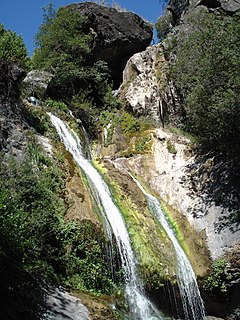
Uvas Canyon County Park is a 1,147-acre (464 ha) natural park located in upper Uvas Canyon on the eastern side of the Santa Cruz Mountains, west of Morgan Hill, California. The park has several small waterfalls, some of which flow perennially, that feed into tributaries confluent with Uvas Creek. The park is part of the Santa Clara County Parks System, and facilitates picnics, hiking and overnight camping. It is one of the few parks in the area that allows dogs in the campgrounds.

The Salmon River is a 33.5-mile (53.9 km) river in the Cascade Range in the U.S. state of Oregon that drains part of southwestern Mount Hood. The entire length of the river is a protected National Wild and Scenic River. Several portions are in protected wilderness. It is affluent to the Sandy River, a tributary of the Columbia River.

The Ventana Wilderness of Los Padres National Forest is a federally designated wilderness area located in the Santa Lucia Range along the Central Coast of California. This wilderness was established in 1969 when the Ventana Wilderness Act redesignated the 55,800-acre (22,600 ha) Ventana Primitive Area as the Ventana Wilderness and added land, totalling 98,000 acres (40,000 ha). In 1978, the Endangered American Wilderness Act added 61,000 acres (25,000 ha), increasing the total wilderness area to about 159,000 acres (64,000 ha). The California Wilderness Act of 1984 added about 2,750 acres (1,113 ha). The Los Padres Condor Range and River Protection Act of 1992 created the approximately 14,500-acre (5,900 ha) Silver Peak Wilderness and added about 38,800 acres (15,700 ha) to the Ventana Wilderness in addition to designating the Big Sur River as a Wild and Scenic River. The Big Sur Wilderness and Conservation Act of 2002 expanded the wilderness for the fifth time, adding nearly 35,000 acres (14,000 ha), increasing the total acreage of the wilderness to its present size of 240,026 acres (97,135 ha).
Darwin Falls is a waterfall located on the western edge of Death Valley National Park near the settlement of Panamint Springs, California. Although there exists a similarly named Darwin Falls Wilderness adjacent to the falls, the falls themselves are located in and administered by Death Valley National Park and the National Park Service. There are several falls, but they are mainly divided into the upper and lower, with a small grotto in between. At a combined 80 feet (24 m), it is the highest waterfall in the park. The canyon is walled by dramatic plutonic rock.

Feather Falls is a waterfall located on the Fall River, a tributary of the Middle Fork Feather River, within the Plumas National Forest in the Sierra Nevada mountain range in Butte County, eastern California, United States.

Salmon Falls is a former settlement in El Dorado County, California. It was located on the South Fork of the American River 5.5 miles (9 km) south-southwest of Pilot Hill, at an elevation of 469 feet. It was flooded by Folsom Lake. Nearby were waterfalls from which the place got its name. The site is now registered as California Historical Landmark #571.

Scott's Gulf is a canyon situated along the Caney Fork River in White County, Tennessee, in the southeastern United States. The canyon stretches for approximately 18 miles (29 km) as the Caney Fork drops from the top of the Cumberland Plateau down to the eastern Highland Rim. This remote section of the river is home to a wilderness area consisting of a largely undisturbed deciduous forest, numerous waterfalls, caves and other geological formations, and Class IV and Class V whitewater rapids.
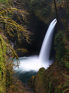
Metlako Falls is a waterfall on Eagle Creek in the Columbia River Gorge National Scenic Area in Hood River County, Oregon, United States. It is the furthest downstream of the major waterfalls on Eagle Creek. Like upstream Punch Bowl Falls, Metlako is also in the form of a punchbowl. The falls is 31 meters (101 ft) tall, though people have measured it anywhere from 30 to 46 m tall. It is the upstream limit for salmon spawning in Eagle Creek.
The Silver Peak Wilderness is located in the southwestern corner of Monterey County in the Santa Lucia Mountains along the Central Coast of California. It southern boundary largely follows the Monterey County/San Luis Obispo County line. Its eastern boundary is defined by Ft. Hunter Liggett, while on the west it follows closely along Highway 1 and the Big Sur coastline. It is one of ten wilderness areas within the Los Padres National Forest and managed by the US Forest Service.
The Taylor River is a river in King County in Washington.

Eagle Creek is a tributary of the Columbia River in Multnomah and Hood River counties in the U.S. state of Oregon. It cuts through a narrow canyon in its 3,200 feet (980 m) descent to the Columbia River Gorge and is known for its concentration of 13 waterfalls in about 5 miles (8.0 km) distance. Eight major falls are on Eagle Creek and the East Fork Eagle Creek itself, while five are on its tributaries.

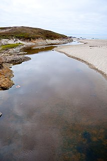
McWay Creek is a 2.5-mile-long (4.0 km) coastal stream in Monterey County in the U.S. state of California. It flows steeply west and south from McWay Canyon, high in California's Central Coast Range, and spills into the Pacific Ocean at Waterfall Cove after flowing over scenic McWay Falls. Most of the creek and its watershed are contained within Julia Pfeiffer Burns State Park, 12 miles (19 km) south of Pfeiffer Big Sur State Park. The creek is named after Christopher McWay from New York, a pioneer who homesteaded the property.
Virgin Creek is a small stream in Mendocino County, California north of Fort Bragg. It is approximately 2.9 miles (4.7 km) long, with no tributaries, and drains a watershed area of approximately 4.2 square miles (11 km2). It passes from forested areas near its headwaters, at an elevation of 320 feet (98 m), through residential developments, to a sandy beach on the Pacific Ocean in MacKerricher State Park at its mouth. Approximately 1.5 miles (2.4 km) from the mouth, it passes over a waterfall approximately 9 feet (2.7 m) high that may form a barrier for fish; below the waterfall, young salmon have been observed.
The Matilija Wilderness is a 29,207-acre (11,820 ha) wilderness area in Ventura and Santa Barbara Counties, Southern California. It is managed by the U.S. Forest Service, being situated within the Ojai Ranger District of the Los Padres National Forest. It is located adjacent to the Dick Smith Wilderness to the northwest and the Sespe Wilderness to the northeast, although it is much smaller than either one. The Matilija Wilderness was established in 1992 in part to protect California condor habitat.

Big Sur Coast Highway is a section of California State Route 1 through the Big Sur region of California that is widely considered to be one of the most scenic driving routes in the United States, if not the world. It is both a National Scenic Highway and a California Scenic Highway, and was described by Australian painter Francis McComas as the "greatest meeting of land and water in the world". Condé Nast Traveler named State Route 1 through Big Sur one of the top ten world-famous streets, comparable to Broadway in New York City and the Champs-Élysées in Paris. The road itself is a destination for visitors.
The Southern Redwood Botanical Area is a 17 acres (6.9 ha) ecological preserve in the southern region of Big Sur in Monterey County, California, just north of the national forest's Salmon Creek trailhead. Established by the Los Padres National Forest of the United States Forest Service, it contains the southernmost naturally occurring Redwood. The trees are located in the Little Redwood Gulch watershed adjacent to the Silver Peak Wilderness. The area is just north of the Salmon Creek trailhead.

Pete Lake is a small alpine freshwater lake located on the southern stretch of the Alpine Lakes Wilderness in Kittitas County, Washington. Because of its proximity to the Pacific Crest Trail and Cle Elum Lake and Kachess Lake, Pete Lake is a popular area for hiking, camping, and fishing. Pete Lake is a short distance and along the trails that lead to Spectacle Lake at the base of Chikamin Peak and Cooper Lake to the South. Trails for backpacking are well-trafficked and originally designed in some areas for enough buffer that allows mountain biking.