The Federal-Aid Highway Act of 1973 is legislation enacted by the United States Congress and signed into law on August 13, 1973, which provided funding for existing interstate and new urban and rural primary and secondary roads in the United States. It also funded a highway safety improvement program, and permitted states for the first time in U.S. history to use Highway Trust Fund money for mass transit. The law also established the first national speed limit.
The United States budget process is the framework used by Congress and the President of the United States to formulate and create the United States federal budget. The process was established by the Budget and Accounting Act of 1921, the Congressional Budget and Impoundment Control Act of 1974, and additional budget legislation.

Charles Jeremy Lewis was an American politician who was a U.S. representative, last serving California's 41st congressional district. He was first elected to Congress in 1978, and previously represented the 40th, 35th, and 37th districts. A Republican, he was chairman of the House Appropriations Committee, serving in that role during the 109th Congress. In January 2012 he announced that he was not running for re-election and would end his congressional career in January 2013.

Carl Trumbull Hayden was an American politician. Representing Arizona in the United States Senate from 1927 to 1969, he was the first U.S. Senator to serve seven terms. Serving as the state's first Representative for eight terms before entering the Senate, Hayden set the record as the longest-serving member of the United States Congress more than a decade before his retirement from politics. He was Dean of the United States Senate and served as its president pro tempore and chairman of both its Rules and Administration and Appropriations committees. He was a member of the Democratic Party.
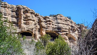
Gila Cliff Dwellings National Monument is a U.S. National Monument created to protect Mogollon cliff dwellings in the Gila Wilderness on the headwaters of the Gila River in southwest New Mexico. The 533-acre (2.16 km2) national monument was established by President Theodore Roosevelt through executive proclamation on November 16, 1907. It is located in the extreme southern portion of Catron County. Visitors can access the monument by traveling northbound from Silver City, New Mexico, 45 miles (72 km) on NM 15.

The Gila National Forest is a protected national forest in New Mexico in the southwestern part of the United States established in 1905. It covers approximately 2,710,659 acres (10,969.65 km2) of public land, making it the sixth largest National Forest in the continental United States. The Forest also manages the part of the Apache National Forest that is in New Mexico which totals an additional 614,202 acres for a total of 3.3 million acres managed by the Gila National Forest. Part of the forest, the Gila Wilderness, was established in 1924 as the first designated wilderness reservation by the U.S. federal government. Aldo Leopold Wilderness and the Blue Range Wilderness are also found within its borders.
Aldo Leopold Wilderness, along with Gila Wilderness and Blue Range Wilderness, is part of New Mexico's Gila National Forest. It became part of the National Wilderness Preservation System in 1980 by an act of the United States Congress and has a total of 202,016 acres (81,753 ha). The wilderness area lies along the crest of the Black Range.

Silver Falls State Park is a state park in the U.S. state of Oregon, located near Silverton, about 20 miles (32 km) east-southeast of Salem. It is the largest state park in Oregon with an area of more than 9,000 acres (36 km2), and it includes more than 24 miles (39 km) of walking trails, 14 miles (23 km) of horse trails, and a 4-mile (6.4 km) bike path. Its 8.7-mile (14.0 km) Canyon Trail/Trail of Ten Falls runs along the banks of Silver Creek and by ten waterfalls, from which the park received its name. Four of the ten falls have an amphitheater-like surrounding that allows the trail to pass behind the flow of the falls. The Silver Falls State Park Concession Building Area and the Silver Creek Youth Camp-Silver Falls State Park are separately listed on the U.S. National Register of Historic Places.
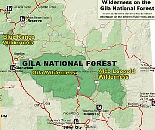
Gila Wilderness was designated the world's first wilderness area on June 3, 1924. Along with Aldo Leopold Wilderness and Blue Range Wilderness, the 558,014 acre wilderness is part of New Mexico's Gila National Forest. The wilderness is approximately 27 miles (43 km) from north to south and 39 miles (63 km) east to west. U.S. Wilderness Areas do not allow motorized or mechanized vehicles, including bicycles. Camping, hunting, and fishing are allowed with proper permit, but no roads, buildings, logging, or mining are permitted. Wilderness areas within National Forests and Bureau of Land Management areas allow hunting in season.
The Milford Flat Fire was the largest wildfire in Utah history. It was started by lightning on Friday, July 6, 2007 at 3:45 pm near Milford, Utah. The fire burned 363,052 acres and caused large stretches of I-15 to be temporarily closed. Many veteran firefighters had stated this was the fastest-moving fire they had ever seen.

Cumbria Fire and Rescue Service is the statutory fire and rescue service for the Shire county of Cumbria, England. Since 2012, the headquarters for the service's 38 fire stations are at Penrith next to the headquarters of Cumbria Constabulary.

The Omnibus Public Land Management Act of 2009 is a land management law passed in the 111th United States Congress and signed into law by President Barack Obama on March 30, 2009. The bill designates millions of acres in the US as protected and establishes a National Landscape Conservation System. It includes funding for programs, studies and other activities by the Department of the Interior and the Department of Agriculture, and in some cases bars further geothermal leasing, oil and gas leasing, and new mining patents on certain stretches of protected land.

The Schultz Fire was a wildfire which burned over 15,000 acres (6,100 ha), including Schultz Peak in Coconino National Forest near Flagstaff, Arizona in June 2010. The suspected cause is a campfire left unattended, and the United States Forest Service is offering a $2500 reward for information.
The Stewardship Contracting Reauthorization and Improvement Act was a bill introduced in the 113th Congress by U.S. Senator Jeff Flake. The bill would have given the federal government more authority to enter into what are known as "forest stewardship contracts", with the goal of reducing the risk of forest wildfires.

The La Brea Fire was a fast moving 2009 wildfire which occurred in Southern California in the United States. The fire began near La Brea Creek in Santa Barbara County, in the Los Padres National Forest. The fire started burning on August 8, and just 5 days later on August 13 had grown by 10,000 acres, or 40 sq. km. When the wildfire was finally contained on August 22, it had burned 89,489 acres of land. The huge Zaca Fire burned in the same region as the La Brea Fire, and occurred just two years prior in 2007.

The Barry Point Fire was a wildfire that burned over 92,977 acres (376.26 km2) of Oregon and California forest land during the summer of 2012. The fire began on 5 August 2012, the result of a lightning strike. The fire consumed public forest and rangeland as well as private forest and grazing land located in Lake County, Oregon and Modoc County, California. The public lands effected by the fire are administered by the United States Forest Service and the Oregon Department of Forestry. The largest part of the private land was owned by the Collins Timber Company. At the peak of the firefighting effort, there were 1,423 personnel working on the fire. It took 22 days to fully contain the fire and then an additional three weeks to mop it up.
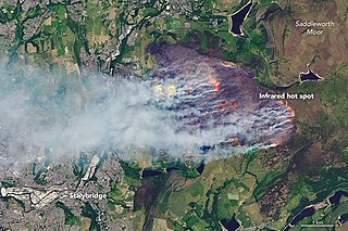
Starting on 24 June 2018 and continuing throughout the summer, a record-breaking series of wildfires burned across the United Kingdom. The two largest fires, which were declared major incidents, burned over 7 square miles each and broke out on Saddleworth Moor in Greater Manchester and Winter Hill in Lancashire. Other large fires broke out in Glenshane Pass in County Londonderry, Northern Ireland, Epping Forest, in London and in the Vale of Rheidol in Ceredigion, Wales. The Saddleworth Moor fire has been described as the largest English wildfire in living memory. Most of the wildfires occurred during the first official heatwave in the United Kingdom since June 2017, with temperatures reaching above 30 °C (86 °F) for several days, making the hottest June in the country since 1995, and the driest June for over ten years in large parts of the United Kingdom, exacerbating the crisis. A wildfire started on the Staffordshire Moorlands on 9 August and, despite rain, had spread to cover 219 acres by 11 August. Some hot spots were still burning as at 22 August. In total, there were 79 fires over the course of the year, a new record. However, the record was beaten in 2019 with 96 fires as of April 23.
The Matilija Fire was a major wildfire that burned nearly 220,000 acres (89,000 ha) in the Santa Barbara National Forest of Southern California, during the autumn of 1932. The fire is named for Matilija Creek, near the location from which it originated.

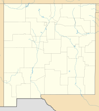
The Black Fire is a massive, active wildfire burning in the northern Black Range in Sierra County, Catron County, and Grant County, Northeast of Silver City, in the state of New Mexico in the United States as part of the 2022 New Mexico wildfire season.

In June through August 2022, parts of Europe, the Middle East and North Africa were affected by wildfires. The bulk of the fires affected Mediterranean Countries, with the main areas affected being Algeria, France, Greece, Portugal and Spain.