
Shimane Prefecture is a prefecture of Japan located in the Chūgoku region of Honshu. Shimane Prefecture is the second-least populous prefecture of Japan at 665,205 and has a geographic area of 6,708.26 km2. Shimane Prefecture borders Yamaguchi Prefecture to the southwest, Hiroshima Prefecture to the south, and Tottori Prefecture to the east.

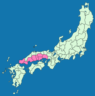
The Chūgoku region, also known as the San'in-San'yō region, is the westernmost region of Honshū, the largest island of Japan. It consists of the prefectures of Hiroshima, Okayama, Shimane, Tottori and Yamaguchi. In 2010, it had a population of 7,563,428.
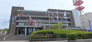
Hamada is a city located in Shimane Prefecture, Japan. As of 31 May 2023, the city had an estimated population of 50,176 in 25498 households and a population density of 73 persons per km2. The total area of the city is 689.68 square kilometres (266.29 sq mi).

Masuda is a city located in Shimane Prefecture, Japan. As of 31 July 2023, the city had an estimated population of 43,885 in 21249 households and a population density of 60 persons per km2. The total area of the city is 733.19 square kilometres (283.09 sq mi).

Hagi is a city located in Yamaguchi Prefecture, Japan. As of 30 April 2023, the city had an estimated population of 43,233 in 22,803 households and a population density of 62 persons per km². The total area of the city is 698.31 square kilometres (269.62 sq mi). It is known for being the birthplace of Hagi ware, a type of Japanese pottery.

Yasugi is a city located in Shimane Prefecture, Japan. As of 31 May 2023, the city had an estimated population of 35,965 in 14257 households and a population density of 85 persons per km2. The total area of the city is 420.93 square kilometres (162.52 sq mi).

Tsuwano is a town located in Kanoashi District, Shimane Prefecture, Japan. As of 30 June 2023, the town had an estimated population of 6,657 in 3352 households and a population density of 22 persons per km². The total area of the town is 307.03 square kilometres (118.54 sq mi). Popularly called the "Little Kyoto of San'in," Tsuwano is known for its picturesque main street, "Tono-machi," which is an Important Preservation District for Groups of Traditional Building lined with Edo period buildings and Koi ponds. Its annual Yabusame festival on the second Sunday of April is a large tourist draw for the San'in region.

The San'yō Region is an area in the south of Honshū, the main island of Japan. It consists of the southern part of the Chūgoku region, facing the Seto Inland Sea. The name San'yō means "southern, sunny (yō) side of the mountains" and contrasts with the San'in or "northern, shady (in) side of the mountains".

The San'in Region is an area in the southwest of Honshū, the main island of Japan. It consists of the northern part of the Chūgoku region, facing the Sea of Japan. Specifically, it is the two prefectures of Shimane and Tottori.

Masuda Station is a passenger railway station located in the city of Masuda, Shimane Prefecture, Japan. It is operated by the West Japan Railway Company.

Tottori is the capital and the largest city of Tottori Prefecture in the Chūgoku region of Japan. As of 30 November 2022, the city had an estimated population of 183,383 in 81,732 households and a population density of 240 persons per km². The total area of the city is 765.31 square kilometres (295.49 sq mi). Most of the city is within the San'in Kaigan Geopark.

Yonago is a city in western Tottori Prefecture, Japan. As of 31 December 2021, the city had an estimated population of 146,139 in 68534 households and a population density of 1100 persons per km2. The total area of the city is 132.42 square kilometres (51.13 sq mi). It is the prefecture's second largest city after Tottori, and forms a commercial center of the western part of this prefecture.
San'yōdō (山陽道) is a Japanese geographical term. It means both an ancient division of the country and the main road running through it. The San'yōdō corresponds for the most part with the modern conception of the San'yō region. This name derives from the idea that the southern side of the central mountain chain running through Honshū was the "sunny" side, while the northern side was the "shady" side.

San'indō (山陰道) is a Japanese geographical term. It means both an ancient division of the country and the main road running through it. San'in translates to "the shaded side of a mountain", while dō, depending on the context, can mean either a road, or a circuit, in the sense of delineating a region. This name derives from the idea that the northern side of the central mountain chain running through Honshū was the "shaded" side, while the southern side was the "sunny" side. The pre-modern region corresponds for the most part with the modern conception of the San'in region.

The Sanin Main Line is a railway line in western Japan, which connects Kyoto and Shimonoseki, Yamaguchi, operated by West Japan Railway Company. It is the major railway line of the San'in region, approximately paralleling the Japan Sea, crossing Kyoto, Hyōgo, Tottori, Shimane, and Yamaguchi prefectures. The main portion from Kyoto to Hatabu is the longest single continuous railway line in Japan at 673.8 km (418.7 mi), although no regularly scheduled train operates over the entire line.

The Chūgoku Expressway is an expressway in Japan, which extends from Suita, Osaka to Shimonoseki, Yamaguchi. It connects Kansai and Chūgoku regions in western Honshu, Japan's main island. Other major cities along the expressway are Tsuyama, Kobe, and Hiroshima. It was opened in 1970, and has a total length of 540.1 kilometers (335.6 mi).

Kamate Station is a passenger railway station located in the city of Masuda, Shimane Prefecture, Japan. It is operated by the West Japan Railway Company.

The Hamada Expressway is a national expressway in the Chūgoku region of Japan. It is owned and operated by West Nippon Expressway Company.

San'in Kinki Expressway is an incomplete expressway that, upon completion, will connect the San'in Expressway from Tottori interchange to the Kyoto Jūkan Expressway. When finished it will be about 120 kilometres (75 mi) long. It is owned and operated by partly by the Kyoto Prefectural Road Corporation and the Ministry of Land, Infrastructure, Transport and Tourism. It is numbered "E9" along with the Kyoto Jūkan Expressway and the San-in Expressway.

The Tottori Expressway is an expressway connecting Sayō in Hyōgo Prefecture and Tottori, the capital and largest city in Tottori Prefecture. It is owned and operated partly by the West Nippon Expressway Company and the Ministry of Land, Infrastructure, Transport and Tourism. The expressway is signed as an auxiliary route of National Route 373 as well as E29 under the Ministry of Land, Infrastructure, Transport and Tourism's "2016 Proposal for Realization of Expressway Numbering."

