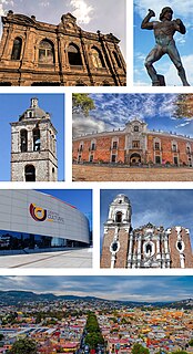
Tlaxcala, officially Tlaxcala de Xicohténcatl, is the capital city of the Mexican state of Tlaxcala and seat of the municipality of the same name. The city did not exist during the pre Hispanic period but was laid out by the Spanish as a center of evangelization and governance after the Spanish conquest of the Aztec Empire. It was designated as a diocese but eventually lost this status to Puebla as its population declined. The city still has many of its old colonial structures including the former Franciscan monastery, as well as newer civic structures such as the Xicohtencatl Theatre.

Xochimilco is one of the 16 mayoralities or boroughs within Mexico City. The borough is centered on the formerly independent city of Xochimilco, which was established on what was the southern shore of Lake Xochimilco in the precolonial period. Today, the borough consists of the eighteen “barrios”, or neighborhoods, of this city along with fourteen “pueblos”, or villages, that surround it, covering an area of 125 km2 (48 sq mi). The borough is in the southeastern part of the city and has an identity that is separate from the historic center of Mexico City, due to its historic separation from that city during most of its history. Xochimilco is best known for its canals, which are left from what was an extensive lake and canal system that connected most of the settlements of the Valley of Mexico. These canals, along with artificial islands called chinampas, attract tourists and other city residents to ride on colorful gondola-like boats called “trajineras” around the 170 km (110 mi) of canals. This canal and chinampa system, as a vestige of the area's precolonial past, has made Xochimilco a World Heritage Site. In 1950, Paramahansa Yogananda, in his Autobiography of a Yogi, wrote that if there were a scenic beauty contest, Xochimilco would get the first prize. However, the impacts of colonization as well as severe environmental degradation of the canals and chinampas have brought that status into question.

Tláhuac is one of the 16 boroughs into which Mexico City is divided. It is located on the south east edge of the district and while much is still rural in character, it has been undergoing urbanization with the fastest rate of population growth in Mexico City since the 1960s. Most of this urbanization is occurring in the northwest of the borough and in some of the larger communities, with the south and east still having significant tracts of farmland, which are under conservation. Much of the area is former lakebed where Lake Chalco and Lake Xochimilco met, with the town of San Pedro Tláhuac originally on an island. There are still some lake areas along with four major canals and wetlands, also under conservation status. The urbanization has led to serious traffic and transportation problems as well as the completion of Line 12 of the Mexico City Metro in 2012, which a terminal in the borough.

Acolman de Nezahualcóyotl is a town and municipality located in the northern part of State of Mexico, part of the Greater Mexico City area, just north of the city proper. According to myth, the first man was placed here after being taken out of Lake Texcoco. In the community of Tepexpan, the fossilized bones more than 12,000 years old of a man were found in the 20th century. The settlement was founded in the 8th century and was an important commerce center at the time of the Spanish conquest of the Aztec Empire. After the Conquest, Acolman became the site of an important Augustinian monastery in the 16th century which still contains important art and architecture from that time period.
The Earliest 16th-century monasteries on the slopes of Popocatépetl are fourteen 16th-century monasteries which were built by the Augustinians, the Franciscans and the Dominicans in order to evangelize the areas south and east of the Popocatépetl volcano in central Mexico. These monasteries were recognized by the UNESCO as World Heritage Sites in 1994, because they served as the model for the early monastery and church buildings as well as evangelization efforts in New Spain and some points beyond in Latin America. These monasteries almost uniformly feature a very large atrium in front of a single nave church with a capilla abierta or open chapel. The atrium functioned as the meeting point between the indigenous peoples and the missionary friars, with mass for the newly converted held outdoors instead of within the church. This arrangement can be found repeated in other areas of Mexico as these friars continued to branch out over New Spain.

Zinacantepec is a town and municipality located just west of the city of Toluca in Mexico State, Mexico. The community is named after a small mountain which contained two caves which used to be filled with thousands of bats. Zinacantepec is Nahuatl for Bat Mountain. Its Aztec glyph is a bat on a mountain. In the 18th century, the population of this mountain moved to settle alongside the Franciscan monastery established here in the 16th century. This monastery is the best preserved of a network of missionaries established in the Toluca Valley in the mid 16th century. Today, the complex functions as the parish church, with the cloister dedicated as the colonial era museum of the state of Mexico.
Santo Domingo in Mexico City refers to the Church of Santo Domingo and its Plaza, also called Santo Domingo. Both are located three blocks north of the Mexico City Metropolitan Cathedral following Republica de Brasil Street with Belisario Dominguez Street separating the two.
Ozumba is a town and municipality located in the southeast portion of the Valley of Mexico, 70 km southeast of Mexico City near the Mexico City-Cuautla highway. The main feature of this area is the Parish of the Immaculate Conception which began as a Franciscan monastery in the 16th century. The entrance to the cloister area contains murals related to the early evangelization efforts of this order. They include scenes such as Hernán Cortés greeting the first Franciscan missionaries in Mexico, the martyrdom of some of the first young converts to Christianity and even a scene where the monks are flogging Cortés. The church itself inside has suffered the theft of a number of its antique pieces. The name Ozumba comes from Nahuatl meaning “over the streams of water”. “de Alzate” was added to the formal name in honor of the scientist José Antonio Alzate y Ramirez Santillana who was born here.

The Convent of San Francisco is located at the western end of Madero Street in the historic center of Mexico City, near the Torre Latinoamericana and is all that remains of the church and monastery complex. This complex was the headquarters of the first twelve Franciscan friars headed by Martín de Valencia who came to Mexico after receiving the first authorization from the Pope to evangelize in New Spain. In the early colonial period, this was one of the largest and most influential monasteries in Mexico City. It was built on the site of where Moctezuma II’s zoo once was. At its peak, the church and monastery covered the blocks now bordered by Bolivar, Madero, Eje Central and Venustiano Carranza Streets, for a total area of 32,224 square meters.
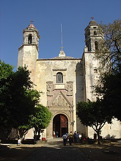
Huejotzingo (modern Nahuatl pronunciation is a small city and municipality located just northwest of the city of Puebla, in central Mexico. The settlement's history dates back to the pre-Hispanic period, when it was a dominion, with its capital a short distance from where the modern settlement is today. Modern Huejotzingo is located where a Franciscan monastery was founded in 1525, and in 1529, the monks moved the indigenous population of Huejotzingo to live around the monastery. Today, Huejotzingo is known for the production of alcoholic apple cider and fruit preserves, as well as its annual carnival. This carnival is distinct as it centers on the re-enactment of several historical and legendary events related to the area. The largest of these is related to the Battle of Puebla, with about 2, 000 residents representing French and Mexican forces that engage in mock battles over four days.
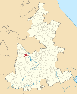
San Pedro Cholula is a municipality in the Mexican state of Puebla and one of two municipalities which made up the city of Cholula. The city has been divided into two sections since the pre Hispanic era, when revolting Toltec-Chichimecas pushed the formerly dominant Olmec-Xicallanca to the eastern side of the city in the 13th century. The new lords called themselves Cholutecas and built a new temple to Quetzalcoatl on the San Pedro side, which eventually eclipsed the formerly prominent Great Pyramid of Cholula, now on the San Andrés side. When the Spanish arrived in the 16th century, the city of Cholula was an important religious and economic center, but the center of power was on the San Pedro side, centered on what is now the main city plaza and the San Gabriel monastery. The division of the city persisted and San Pedro remained the more dominant, with Spanish families moving onto that side and the rest of the population quickly becoming mestizo. Today, San Pedro is still more commercial and less residential than neighboring San Andrés with most of its population employed in industry, commerce and services rather than agriculture. Although Cholula's main tourist attraction, the Pyramid, is in San Andrés, San Pedro has more tourism infrastructure such as hotels, restaurants and bars.

A capilla abierta or “open chapel” is considered to be one of the most distinct Mexican construction forms. Mostly built in the 16th century during the early colonial period, the construction was basically an apse or open presbytery containing an altar, which opened onto a large atrium or plaza. While some state that these were constructed by friars because the native peoples of that epoch were afraid to enter the dark confines of European-style churches, the more likely reasons for their construction were that they allowed the holding of Mass for enormous numbers of people and the arrangement held similarities to the teocallis or sacred precincts of pre-Hispanic temples. While open chapels can be found in other places in Spain and Peru, their systematic use in monasteries and other religious complexes, leading to a regularization of architectural elements, is only found in Mexico.

The Ex-monastery of Santiago Apóstol is located in the town of Cuilapan de Guerrero in the Mexican state of Oaxaca. The fortress-like complex is easily seen from the highway as one travels south from the capital city of Oaxaca on the road leading to Villa de Zaachila, and it is visited by both Mexican and international tourists. The complex is located on a small hill which gives it a view of much of the valley area. It is one of the most extravagant and elaborate colonial era constructions in Oaxaca, but it is often overlooked in favor of churches and monasteries located in the Mexico City area. Built of green quarried stone and river rocks, it is a quiet place where footsteps can echo in the hallways. The extravagances of the site, including the tall basilica, the elaborate baptismal font, the Gothic cloister and murals remain as national treasures. The decorative work of the monastery, especially its murals, are important because they show a systematic blending of indigenous elements into the Christian framework, done in order to support the evangelization process in the local Mixtec and Zapotec peoples. The single-naved church is used for worship but the roofless basilica and cloister are under the control of INAH, which uses many of the second-floor rooms of the cloister as workshops for restoration projects and runs a small museum with important liturgical items from the 16th century.

The Convento de San Esteban is a Dominican monastery situated in the Plaza del Concilio de Trento in the city of Salamanca.

The Cuernavaca Cathedral is the Roman Catholic church of the Diocese of Cuernavaca, located in the city of Cuernavaca, Morelos, Mexico. The church and its surrounding monastery is one of the early 16th century monasteries in the vicinity of the Popocatepetl volcano, built initially for evangelization efforts of indigenous people after the Spanish conquest of the Aztec Empire. By the 18th century, the church of the monastery began to function as the parish church of the city and in the late 19th century, it was elevated to the rank of a cathedral. Unlike many cathedrals in Mexico, this one does not face the city's main square, but rather is located just to the south, in its own walled compound, which it shares with a number of other structures. Unlike the other monastery structures from its time, the importance of this church provoked a number of renovation projects, the last of which occurred in 1957. This one took out the remaining older decorations of the interior and replaced them with simple modern ones. This renovation work also uncovered a 17th-century mural that covers 400 square metres (4,300 sq ft) of the interior walls and narrates the story of Philip of Jesus and twenty three other missionaries who were crucified in Japan.

Pueblo Culhuacán is an officially designated neighborhood of the Iztapalapa borough of Mexico City, which used to be a major pre-Hispanic city. Ancient Culhuacán was founded around 600 CE and the site has been continuously occupied since. The city was conquered by the Aztecs in the 15th century, but the Aztecs considered the city to have status with early rulers marrying into Culhua nobility to legitimize themselves. After the Spanish conquest of the Aztec Empire, the Franciscans and later the Augustinians made Culhuacán a major evangelization center, with the latter building the monastery complex which remains to this day. Today, Culhucan is fully integrated into Mexico City physically and politically. This area was designated as a "Barrio Mágico" by the city in 2011.

The Niñopa or Niñopan is the most venerated image of the Child Jesus in the Mexico City borough of Xochimilco. It was created over 430 years ago in the San Bernardino monastery, as part of evangelization efforts. Since then it has been in the possession of the community. Rather than being kept in the parish church it is in the custody of a sponsor or mayordomo, whose family is in charge of the many festivities and traditions associated with the image for a year. These include taking care of the image proper along with taking the image to church and to visit the sick. It also includes sponsoring many parties especially on certain dates such as Candlemas and Day of the Child on April 30.

Cuitzeo is a town and municipality located in the north of the Mexican state of Michoacán. It is located in a relatively flat depression around Lake Cuitzeo, a large, very shallow lake, which is in danger of disappearing. The town was officially founded in 1550, with the founding of a large Augustinian monastery, which still stands. Today, the town is the seat of a rural municipality, providing local government to surrounding communities.
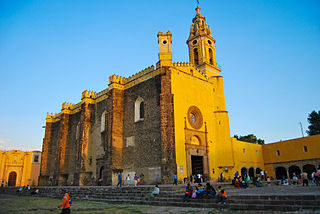
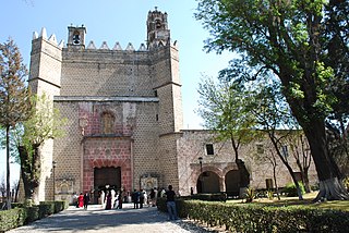
The San Gabriel Franciscan Convent or San Gabriel Friary is a church and friary in Cholula, Metropolitan area of Puebla City, Mexico.

Mendicant monasteries in Mexico were one of the architectural solutions devised by the friars of the Mendicant orders in the 16th century to the evangelization in the New Spain. The religious function of these buildings was thought for an enormous number of Amerindian indigenous people to evangelize although soon, due to the policy of reduction, the whole became the social center of the pueblos de indios, transmitting to them the civil modes of the West, Castilian, various arts and crafts, health, and even funeral services.


