San Dimas (reserve)

Last updated
San Dimas Biosphere Reserve and Experimental Forest
San Dimas Experimental Forest San Dimas Canyon.jpg
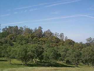
View down San Dimas Canyon
Relief map of California.png
Red pog.svg
Usa edcp relief location map.png
Red pog.svg
Location Angeles National Forest, Los Angeles County, USA
Nearest city Glendora, California
Coordinates 34°12′N117°46′W / 34.200°N 117.767°W / 34.200; -117.767
Area6,495 hectares (25.08 sq mi)
Governing body United States Forest Service

The San Dimas Biosphere Reserve and Experimental Forest is an experimental forest located in the front range of the San Gabriel Mountains of southern California. San Dimas constitutes a protected field laboratory jointly managed by the Angeles National Forest and the Pacific Southwest Research Station of the United States Forest Service under the designation San Dimas Experimental Forest. It was designated as a UNESCO Biosphere Reserve in 1976 and withdrawn from the programme in July 2018. [1] [2] [3]

An experimental forest, or experimental range, as defined by the United States Forest Service, is "an area administered ... 'to provide for the research necessary for the management of the land.'"

San Gabriel Mountains mountain range in Los Angeles and San Bernardino Counties, California

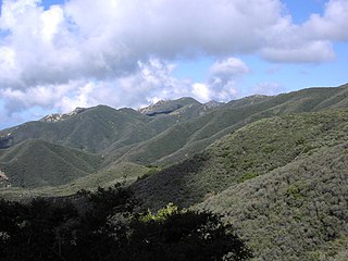
The San Gabriel Mountains are a mountain range located in northern Los Angeles County and western San Bernardino County, California, United States. The mountain range is part of the Transverse Ranges and lies between the Los Angeles Basin and the Mojave Desert, with Interstate 5 to the west and Interstate 15 to the east. This range lies in, and is surrounded by, the Angeles National Forest, with the San Andreas Fault as the northern border of the range.

Angeles National Forest

The Angeles National Forest (ANF) of the U.S. Forest Service is located in the San Gabriel Mountains and Sierra Pelona Mountains, primarily within Los Angeles County in southern California. The ANF manages a majority of the San Gabriel Mountains National Monument.

It encompasses the upper Big Dalton and San Dimas watersheds. The 6,495 hectares (25.08 sq mi) experimental forest was originally established in 1933 and was designated as a biosphere reserve in 1976. [1] [4]

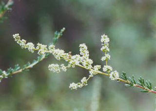
San Dimas is a chaparral-dominated Mediterranean ecosystem. In addition to the chaparral vegetation (including chamise), riparian woodland, sage-buckwheat and barren areas, oak woodland and open yellow pine woodlands are represented. The Fern Canyon Research Natural Area is in the remote eastern part the San Dimas reserve. This 555 hectares (2.14 sq mi) Research Natural Area includes Brown's Flat, a locally unique mountain meadow that supports a relict grove of ponderosa pine (Pinus ponderosa Douglas ex C. Lawson). [4] [5]

Chaparral shrubland or heathland plant community found primarily in the US state of California and in the northern portion of the Baja California Peninsula, Mexico.

Chaparral is a shrubland or heathland plant community found primarily in the US state of California and in the northern portion of the Baja California Peninsula, Mexico. It is shaped by a Mediterranean climate and wildfire, featuring summer-drought-tolerant plants with hard sclerophyllous evergreen leaves, as contrasted with the associated soft-leaved, drought-deciduous, scrub community of coastal sage scrub, found below the chaparral biome. Chaparral covers 5% of the state of California and associated Mediterranean shrubland an additional 3.5%. The name comes from the Spanish word chaparro, for evergreen oak shrubland.

<i>Adenostoma fasciculatum</i> species of plant

Adenostoma fasciculatum, the chamise or greasewood, is a flowering plant native to Oregon, Nevada, California, and northern Baja California. This shrub is one of the most widespread plants of the chaparral biome.

Riparian forest forested or wooded area of land adjacent to a body of water

A riparian forest or riparian woodland is a forested or wooded area of land adjacent to a body of water such as a river, stream, pond, lake, marshland, estuary, canal, sink or reservoir.

In addition to Fern Canyon, the reserve's research facilities include over 50 gauged watersheds, a lysimeter complex, two major dams and reservoirs—San Dimas Dam and Big Dalton Dam—and three plantations of domestic and introduced trees. [5]

Lysimeter meteorological instrumentation

A lysimeter is a measuring device which can be used to measure the amount of actual evapotranspiration which is released by plants. By recording the amount of precipitation that an area receives and the amount lost through the soil, the amount of water lost to evapotranspiration can be calculated. Lysimeters are of two types: weighing and non-weighing.

San Dimas Dam

San Dimas Dam is a concrete gravity dam in Los Angeles County, California. The dam and its flood control basin/reservoir are in the San Gabriel Mountains and within the Angeles National Forest. The dam is currently operated by the Los Angeles County Department of Public Works but was originally built by the Los Angeles County Flood Control District in 1922. The dam controls flooding from San Dimas Creek, a major San Gabriel Mountains drainage and tributary of the San Gabriel River. As a flood control facility the San Dimas Reservoir is dry for most of the year, only storing water after significant winter storms. The regulation provided by the dam allows for the efficient diversion of floodwaters from San Dimas Wash to Puddingstone Reservoir, which protects the San Dimas area of the San Gabriel Valley.

Big Dalton Dam flood control dam in Los Angeles County, California, USA

Big Dalton Dam is a multiple arch concrete dam in Los Angeles County, California, built for the Los Angeles County Flood Control District and completed in August 1929. The dam is one of the earliest of the multiple arch "double-wall" buttress designs of engineer Fred A. Noetzli. The 991 acre-foot dam provides water conservation and controls flooding from Big Dalton Canyon, a watershed within the San Dimas Experimental Forest, part of the Angeles National Forest in the San Gabriel Mountains. It is about 4 miles northeast of the city of Glendora and is operated by the Los Angeles County Department of Public Works.

Studies at San Dimas have provided valuable information on air pollution, fire effects, erosion, hydrology, and plants and animals in southern California watersheds. The area also provides opportunities for ecological research to many nearby colleges, universities and governmental agencies. [2]

Hydrology The science of the movement, distribution, and quality of water on Earth and other planets

Hydrology is the scientific study of the movement, distribution, and quality of water on Earth and other planets, including the water cycle, water resources and environmental watershed sustainability. A practitioner of hydrology is a hydrologist, working within the fields of earth or environmental science, physical geography, geology or civil and environmental engineering. Using various analytical methods and scientific techniques, they collect and analyze data to help solve water related problems such as environmental preservation, natural disasters, and water management.

Wildfires have frequently burned through the San Dimas area, most recently when the Williams Fire burned much of the forest in September 2002. [4]

Wildfire uncontrolled fire in an area of combustible vegetation that occurs in the countryside or a wilderness area

A wildfire or wildland fire is a fire in an area of combustible vegetation occurring in rural areas. Depending on the type of vegetation present, a wildfire can also be classified more specifically as a brush fire, bushfire, desert fire, forest fire, grass fire, hill fire, peat fire, vegetation fire, or veld fire.

The forest is currently closed for the general public, except under special written permit. No hunting or other recreational activities are currently allowed. [2]

Sources

Definition of Free Cultural Works logo notext.svg  This article incorporates text from a free content work. License statement : UNESCO - MAB Biosphere Reserves Directory , UNESCO, UNESCO. To learn how to add open license text to Wikipedia articles, please see this how-to page . For information on reusing text from Wikipedia , please see the terms of use .

PD-icon.svg This article incorporates  public domain material from websites or documents ofthe United States Forest Service .

Related Research Articles

Shasta–Trinity National Forest

The Shasta–Trinity National Forest is a federally designated forest in northern California, USA. It is the largest National Forest in California and is managed by the U.S. Forest Service. The 2,210,485 acre forest encompasses five wilderness areas, hundreds of mountain lakes and 6,278 miles (10,103 km) of streams and rivers. Major features include Shasta Lake, the largest man-made lake in California and Mount Shasta, elevation 14,179 feet (4,322 m).

Desert Biosphere Reserve biosphere reserve in United States of America (designated in 1976, withdrawn 2017) and historic district

The Desert Biosphere Reserve and Experimental Range is a biosphere reserve and experimental range in western Millard County, Utah, United States, that is listed as a historic district on the National Register of Historic Places.

Golden Gate Biosphere Reserve nature reserve in northern California, USA

The Golden Gate Biosphere is a biosphere reserve in Northern California. It was created by UNESCO in 1988 and encompasses 13 protected areas in the San Francisco Bay Area. It extends through the central California coastal region from the Bodega Marine Reserve in the north to Jasper Ridge in the south and includes the Farallon Islands, Angel Island, and Alcatraz within the San Francisco Bay. The biosphere reserve is situated on both sides of the San Andreas Fault. Each side has a completely different type of bedrock, and the western side of the rift is moving northward. It encompasses a diverse range of marine, coastal, and upland habitats of the California chaparral and woodlands and Northern California coastal forests ecoregions, including mixed evergreen forests, Coast Redwood forests, Douglas-fir forests, Bishop pine forests, oak forests, woodlands and savannas, northern coastal scrub, chaparral, coastal dune, coastal strand, tidepools, kelp forests, coastal grasslands, and marshes. The associated fauna is also rich with cougars, Tule elk, California sea lions, elephant seals, and many shorebirds.

California Coast Ranges mountain range

The Coast Ranges of California span 400 miles (640 km) from Del Norte or Humboldt County, California, south to Santa Barbara County. The other three coastal California mountain ranges are the Transverse Ranges, Peninsular Ranges and the Klamath Mountains.

Landels-Hill Big Creek Reserve nature reserve in Calfornia, USA

The Landels-Hill Big Creek Reserve is a constituent of the University of California Natural Reserve System. It is located off State Route 1 in the Big Sur area on California's central coast, fifty miles south of Monterey and adjacent to the Big Creek State Marine Reserve and Big Creek State Marine Conservation Area.

San Joaquin Experimental Range ecosystem research experimental area in California

The San Joaquin Experimental Range is an ecosystem research experimental area in the foothills of the Sierra Nevada. The range is located in O'Neals, California, outside of the Sierra National Forest about 32 kilometres (20 mi) north of Fresno, California.

Angelo Coast Range Reserve nature reserve in California, USA

The Angelo Coast Range Reserve is located in the Northern Outer California Coast Ranges, in Mendocino County, Northern California. The 7,660-acre reserve includes a section of the Eel River.

The Champlain-Adirondack Biosphere Reserve is a UNESCO-designated biosphere reserve.

California Coast Ranges (reserve) Biosphere reserve in United States of America,  designated in 1983 and withdrawn in 2017

The California Coast Ranges Biosphere Reserve was a UNESCO Biosphere reserve located along the California Coast Ranges of northern California and the San Francisco Bay area until June 2017. This biosphere reserve includes a highly diverse complex of evergreen sclerophyllous woodland, coastal, estuary and marine ecosystems.

Sequoia-Kings Canyon Biosphere reserve in United States Of America | designated in 1976

Sequoia-Kings Canyon Biosphere Reserve is a UNESCO Biosphere Reserve located in the southern Sierra Nevada of California. The 349,543 hectares (1,349.59 sq mi) biosphere reserve comprises Sequoia and Kings Canyon National Parks.

Niwot Ridge is an alpine ecology research station located 65 km north-west of Denver in north-central Colorado. It is on the Front Range of the southern Rocky Mountains and lies within the Roosevelt National Forest.

San Joaquin Biosphere Reserve Biosphere reserve in United States Of America | designated in 1976

The San Joaquin Biosphere Reserve is a UNESCO Biosphere Reserve located on the western slopes of the central Sierra Nevada mountains Madera County, California, about 20 miles (32 km) north of Fresno. This biosphere reserve represents the California steppe and California woodlands with blue oak, interior live oak. and digger pine.

Central Plains Biosphere Reserve Biosphere reserve in United States Of America,  designated in 1976 and withdrawn in 2017

The Central Plains Biosphere Reserve was a UNESCO Biosphere Reserve located in the western central Great Plains in north-central Colorado in the shortgrass prairie. The 6,210 hectares (24.0 sq mi) reserve encompasses the Central Plains Experimental Range (CPER) administered by the United States Department of Agriculture's Agricultural Research Service.

Fraser Biosphere Reserve Biosphere reserve in United States Of America | designated in 1976, withdrawn 2017

The Fraser Biosphere Reserve and Experimental Forest is a former UNESCO Biosphere Reserve situated on the west side of the Continental Divide in north-central Colorado and includes the entire watershed of Main St. Louis Creek, a tributary of the Fraser River.

Jornada Biosphere Reserve Biosphere reserve in United States Of America | designated in 1976

The Jornada Biosphere Reserve is a UNESCO Biosphere Reserve in southern New Mexico. It is one of three biosphere reserves representing the Chihuahuan Desert. The area extends from the crest of the San Andres Mountains, which are dominated by shrub woodlands, to the Jornada Plains characterized by semi-desert grasslands.

Stanislaus-Tuolumne Biosphere Reserve biosphere reserve in United States of America | designated in 1976, withdrawn 2017; experimental forest

The Stanislaus-Tuolumne Biosphere Reserve and Experimental Forest was a UNESCO Biosphere Reserve established 1976 and withdrawn in 2017. It encompasses the Stanislaus-Tuolumne Experimental Forest, an experimental forest under the management of the United States Forest Service. Stanislaus-Tuolumne is located on the western slopes of the central Sierra Nevada mountains near Pinecrest, California about 15 kilometres (9.3 mi) northwest of Yosemite National Park.

Middle Zambezi Biosphere Reserve Biosphere reserve in Zimbabwe | designated in 2010

The Middle Zambezi Biosphere Reserve is a UNESCO Biosphere Reserve located along the Zambezi River in the Zambezi Valley of Zimbabwe. The 2,879,300 hectares (11,117 sq mi) reserve consists of riverine and terrestrial ecosystems unique to the subcontinent. Among threatened species found in the valley are the black rhino, the painted wild dog, and the nyala. The flora consist of Colophospermum/Combretum/Terminalia woodland and the Zambezi riparian forest. At Mana Pools, it comprises the only flood plain ecosystem left in the Middle Zambezi.

Lake Manyara Biosphere Reserve Biosphere reserve in United Republic Of Tanzania | designated in 1981

The Lake Manyara Biosphere Reserve is a UNESCO Biosphere Reserve in the depression of the East African Rift Valley in the Lake Manyara Basin in northern Tanzania. The reserve is managed by Tanzanian Lake Manyara National Park.

References

  1. 1 2 "San Dimas". Pacific Southwest Research Station. U.S. Forest Service. Retrieved 23 May 2016.
  2. 1 2 3 "UNESCO MAB Reserves Directory: San Dimas" . Retrieved 5 September 2018.
  3. UNESCO (26 July 2018). "Twenty-four new sites join UNESCO's World Network of Biosphere Reserves 26 July 2018" . Retrieved 5 September 2018.
  4. 1 2 3 "San Dimas Experimental Forest Facilities". Pacific Southwest Research Station. U.S. Forest Service. Retrieved 23 May 2016.
  5. 1 2 "USDA Forest Service General Technical Report PSW-119" (PDF). U.S. Forest Service. 1990. Retrieved 28 May 2016.

Coordinates: 34°12′N117°46′W / 34.200°N 117.767°W / 34.200; -117.767