
Trinidad and Tobago is an archipelagic republic in the southern Caribbean between the Caribbean Sea and the North Atlantic Ocean, northeast of Venezuela. They are southeasterly islands of the Lesser Antilles, Monos, Huevos, Gaspar Grande, Little Tobago, and St. Giles Island. Trinidad is 11 km (6.8 mi) off the northeast coast of Venezuela and 130 km (81 mi) south of the Grenadines. The island measures 4,768 km2 (1,841 sq mi) in area with an average length of 80 km (50 mi) and an average width of 59 km (37 mi). The island appears rectangular in shape with three projecting peninsular corners. Tobago is 30 km (19 mi) northeast of Trinidad and measures about 298 km2 (115 sq mi) in area, or 5.8% of the country's area, 41 km (25.5 mi) in length and 12 km (7.5 mi) at its greatest width. The island is cigar-shaped in appearance, with a northeast–southwest alignment.
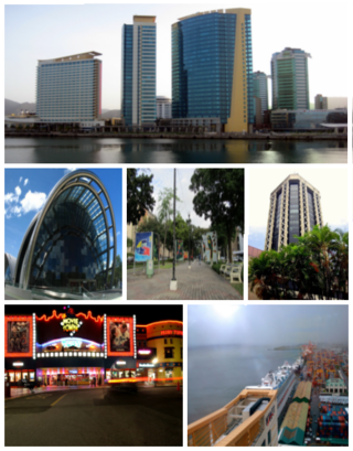
Port of Spain, officially the City of Port of Spain, is the capital of Trinidad and Tobago and the third largest municipality, after Chaguanas and San Fernando. The city has a municipal population of 37,074, an urban population of 81,142 and a transient daily population of 250,000. It is located on the Gulf of Paria, on the northwest coast of the island of Trinidad and is part of a larger conurbation stretching from Chaguaramas in the west to Arima in the east with an estimated population of 600,000.

Trinidad is the larger and more populous of the two major islands of Trinidad and Tobago. The island lies 11 km (6.8 mi) off the northeastern coast of Venezuela and sits on the continental shelf of South America. It is often referred to as the southernmost island in the West Indies. With an area of 4,768 km2 (1,841 sq mi), it is also the fifth largest in the West Indies.

San Fernando, officially the City of San Fernando, is the most populous city and second most populous municipality in Trinidad and Tobago, after Chaguanas. Sando, as it is also known, occupies 19 km² and is located in the southwestern part of the island of Trinidad. It is bounded to the north by the Guaracara River, the south by the Oropouche River, the east by the Sir Solomon Hochoy Highway, and the west by the Gulf of Paria. The former borough was elevated to the status of a city corporation on 18 November 1988. The motto of San Fernando is: "Sanitas Fortis" - In a Healthy Environment We Will Find Strength. Many local Trinidadians refer to the city with the shortened name "Sando." San Fernando is called Trinidad and Tobago's "industrial capital" because of its proximity to the Pointe-à-Pierre oil refinery and many other petrochemical, LNG, iron and steel and aluminium smelters in places such as Point Lisas in Couva, Point Fortin, and La Brea.

The Borough of Chaguanas is the largest municipality and fastest-growing town in Trinidad and Tobago. Located in west-central Trinidad, south of Port of Spain, north of Couva and San Fernando, and named after the indigenous tribe who originally settled there, it grew in size due to its proximity to the Woodford Lodge sugar refinery. It remained a minor town until the 1980s when it began to grow rapidly as it drew people for its bargain shopping and moderately priced housing. Its rapid growth has seen property values increase dramatically, however.

Naparima College is a public secondary school for boys in Trinidad and Tobago. Located in San Fernando, the school was founded in 1894 but received official recognition in 1900. It was established by Dr. Kenneth J. Grant, a Canadian Presbyterian missionary working among the Indian population in Trinidad. The school was one of the first to educate Indo-Trinidadians and played an important and crucial role in the development of an Indo-Trinidadian and Tobagonian professional class. Naparima is derived from the Arawak word (A) naparima, meaning ‘large water’, or from Nabarima, Warao for ‘Father of the waves’.

The Northern Range is the range of tall hills across north Trinidad, the major island in the Republic of Trinidad and Tobago. The hills range from the Chaguaramas peninsula on the west coast to Toco in the east. The Northern Range covers approximately twenty-five percent of the land area of Trinidad.
Princes Town is a town within the Princes Town Regional Corporation, located on southern Trinidad island in Trinidad and Tobago. The population of the town is 28,335.

The Nariva Swamp is the largest freshwater wetland in Trinidad and Tobago and has been designated a Wetland of International Importance under the Ramsar Convention. The swamp is located on the east coast of Trinidad, immediately inland from the Manzanilla Bay through Biche and covers over 60 square kilometres (23 mi2). The Nariva Swamp is extremely biodiverse. It is home to 45 mammal species, 39 reptile species, 33 fish species, 204 bird species, 19 frog species, 213 insect species and 15 mollusc species. All this contained in just 60 square kilometers.
Ralph Maraj is a Trinidad and Tobago politician, actor, playwright, and teacher. He served as Minister of Foreign Affairs under a People's National Movement (PNM) administration, Minister of Communication and Information Technology under a United National Congress (UNC) administration, and was a founding member of National Team Unity before returning to the PNM to work as a speech writer for Prime Minister Patrick Manning. Prior to entering politics in 1991, Maraj worked as a teacher at Naparima College in San Fernando. He also attended that school. He wrote several plays, the most successful being Cynthia Sweetness. Maraj also starred in the movies The Right and The Wrong (1969) and Bim (1974), described by Bruce Paddington as "one of the most important films to be produced in Trinidad and Tobago".

The Sir Solomon Hochoy Highway, sometimes referred to as SHH, is the major north–south highway on the island of Trinidad, in Trinidad and Tobago. It runs for 35.6 km.

Presentation College San Fernando is a selective, government-assisted Roman Catholic Boys’ Secondary School located in San Fernando, Trinidad and Tobago. It claims to be the first Catholic secondary school in South Trinidad, having been established around 1930 in the basement of San Fernando Presbytery. It relocated to the Colony Buildings at La Pique in 1931. Originally named St. Benedict's College, the name was changed in 1948 when management of the school was assumed by the Presentation Brothers.

Naparima Girls' High School is an all-girls high school in San Fernando, Trinidad and Tobago. The school was founded in 1912 by Rev Dr. Fulton Coffin to complement the education offered to boys by Naparima College. It is located on La Pique Hill which overlooks San Fernando.
Lall Ramnath Sawh CMT, FRCS (Edin), FACS is a Trinidadian urologist in the Caribbean and Latin America. Based in Trinidad and Tobago, Sawh was a pioneer of kidney transplantation in the Caribbean in 1988 and is a recognized leader in the field of urology.
The Presbyterian Church of Trinidad and Tobago is a Presbyterian church in Trinidad and Tobago, established by missionaries from the Presbyterian Church in Canada.

Pelau is a traditional rice dish of the West Indies. Main ingredients are meat, rice, pigeon peas or cowpeas, coconut milk and sugar; various vegetables and spices are optional ingredients. Spices used in the dish include cardamom, cloves, cumin and coriander. The meat is caramelised and the other ingredients are then added one by one, resulting in a dark brown stew.
Stella Piari Abidh (1903–1989) was a Trinidad and Tobago public health physician. She served as the Medical Officer of Health for San Fernando and as medical supervisor of schools in south Trinidad. She is believed to be the first Indo-Trinidadian woman to become a doctor.

