
A biome is a collection of plants and animals that have common characteristics for the environment they exist in. They can be found over a range of continents. Biomes are distinct biological communities that have formed in response to a shared physical climate. Biome is a broader term than habitat; any biome can comprise a variety of habitats.

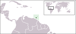
Trinidad and Tobago is an archipelagic republic in the southern Caribbean between the Caribbean Sea and the North Atlantic Ocean, northeast of Venezuela. They are southeasterly islands of the Lesser Antilles, Monos, Huevos, Gaspar Grande, Little Tobago, and St. Giles Island. Trinidad is 11 km (6.8 mi) off the northeast coast of Venezuela and 130 km (81 mi) south of the Grenadines. The island measures 4,768 km2 (1,841 sq mi) in area with an average length of 80 km (50 mi) and an average width of 59 km (37 mi). The island appears rectangular in shape with three projecting peninsular corners. Tobago is 30 km (19 mi) northeast of Trinidad and measures about 298 km2 (115 sq mi) in area, or 5.8% of the country's area, 41 km (25.5 mi) in length and 12 km (7.5 mi) at its greatest width. The island is cigar-shaped in appearance, with a northeast-southwest alignment.
The Global 200 is the list of ecoregions identified by WWF, the global conservation organization, as priorities for conservation. According to WWF, an ecoregion is defined as a "relatively large unit of land or water containing a characteristic set of natural communities that share a large majority of their species dynamics, and environmental conditions". So, for example, based on their levels of endemism, Madagascar gets multiple listings, ancient Lake Baikal gets one, and the North American Great Lakes get none.
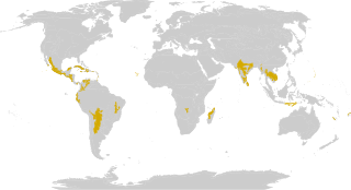
The tropical and subtropical dry forest is a habitat type defined by the World Wide Fund for Nature and is located at tropical and subtropical latitudes. Though these forests occur in climates that are warm year-round, and may receive several hundred centimeters of rain per year, they have long dry seasons which last several months and vary with geographic location. These seasonal droughts have great impact on all living things in the forest.
The Antarctic flora is a distinct community of vascular plants which evolved millions of years ago on the supercontinent of Gondwana. It is now found on several separate areas of the Southern Hemisphere, including southern South America, southernmost Africa, New Zealand, Australia and New Caledonia. Joseph Dalton Hooker was the first to notice similarities in the flora and speculated that Antarctica had served as either a source or a transitional point, and that land masses now separated might formerly have been adjacent.

The Puerto Rican dry forests are a tropical dry forest ecoregion located in southwestern and eastern Puerto Rico and on the offshore islands. They cover an area of 1,300 km2 (500 sq mi). These forests grow in areas receiving less than 1,000 mm (39 in) of rain annually. Many of the trees are deciduous, losing their leaves during the dry season which normally lasts from December to April.
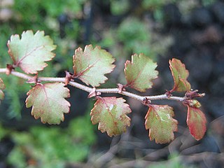
Laurel forest, also called laurisilva or laurissilva, is a type of subtropical forest found in areas with high humidity and relatively stable, mild temperatures. The forest is characterized by broadleaf tree species with evergreen, glossy and elongated leaves, known as "laurophyll" or "lauroid". Plants from the laurel family (Lauraceae) may or may not be present, depending on the location.

Taï National Park is a national park in Côte d'Ivoire that contains one of the last areas of primary rainforest in West Africa. It was inscribed as a World Heritage Site in 1982 due to the breadth of its flora and fauna. Five mammal species of the Taï National Park are on the Red List of Threatened Species: pygmy hippopotamus, olive colobus monkeys, leopards, chimpanzees and Jentink's duiker.
Howard Nelson, Ph.D. is a Trinidadian ecologist and wildlife biologist. Nelson earned his bachelor's and master's degrees at the University of the West Indies and his doctoral work at the University of Wisconsin–Madison under the guidance of Stanley Temple. For his MPhil degree he conducted an ecological study of the mammalian community of Trinidad, including the first camera trapping study of the ocelot on Trinidad and the first survey of game mammals. For his doctoral work Nelson completed a re-classification of the vegetation communities of Trinidad and Tobago, a massive undertaking which updates John Stanley Beard's 1946 classification.
Trinidad and Tobago are continental islands with a geologically very recent history of direct land bridge connection to South America. As a result, unlike most of the Caribbean Islands, Trinidad and Tobago supports a primarily South American flora and fauna and has greater diversity of plant and animal species than the Antilles. However, rates of endemism are lower than in the rest of the Caribbean because there has been less time for genetic isolation from mainland populations because of the history of land bridge connections and hence fewer opportunities for speciation, and so a greater proportion of the species in Trinidad and Tobago are also found on the South American mainland. Trinidad is nearer to mainland South America and has been directly connected to the mainland via land bridges more often and for longer periods than Tobago. This, as well as Trinidad's larger size and more varied topography and hydrology compared to that of Tobago allow greater species and ecosystem diversity on the former compared to that on the later of the islands.
The Yungas is a narrow band of forest along the eastern slope of the Andes Mountains from Peru, Bolivia, and northern Argentina. It is a transitional zone between the Andean highlands and the eastern forests. Like the surrounding areas, the Yungas belong to the Neotropical realm; the climate is rainy, humid, and warm.
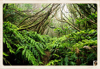
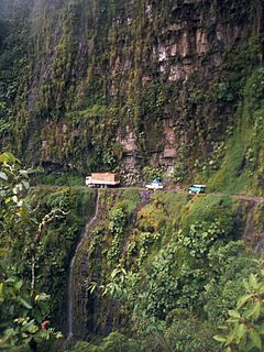
Main Ridge is the main mountainous ridge on the island of Tobago, Trinidad and Tobago. It is a 29-kilometre (18 mi) chain of hills which runs from southwest to northeast between the Caribbean Sea and the Southern Tobago fault system and reaches a maximum height of 572 m (1,877 ft). The Main Ridge Forest Reserve, which was legally established in 1776, is one of the oldest protected areas in the world. It is a popular site for birdwatching and ecotourism. Main Ridge provides important habitat for native plants and animals, including several species endemic to Tobago.

The Grenada dove is a medium-sized New World tropical dove. It is endemic to the island of Grenada in the Lesser Antilles. Originally known as the pea dove or Well's dove, it is the national bird of Grenada. It is considered to be one of the most critically endangered doves in the world.

Richeria grandis is a tree species in the family Phyllanthaceae which ranges from the Lesser Antilles to South America. The species is reputed to have aphrodisiac properties.

Biogeographic classification of India is the division of India according to biogeographic characteristics. Biogeography is the study of the distribution of species (biology), organisms, and ecosystems in geographic space and through geological time. India has a rich heritage of natural diversity. India ranks fourth in Asia and tenth in the world amongst the top 17 mega-diverse countries in the world. India harbours nearly 11% of the world’s floral diversity comprising over 17500 documented flowering plants, 6200 endemic species, 7500 medicinal plants and 246 globally threatened species in only 2.4% of world’s land area. India is also home to four biodiversity hotspots—Andaman & Nicobar Islands, Eastern Himalaya, Indo-Burma region, and the Western Ghats. Hence the importance of biogeographical study of India's natural heritage.

Seasonal tropical forest, also known as moist deciduous, semi-evergreen seasonal, tropical mixed or monsoon forests, typically contain a range of tree species: only some of which drop some or all of their leaves during the dry season. This tropical forest is classified under the Walter system as (ii) tropical climate with high overall rainfall concentrated in the summer wet season and dry season: representing a range of habitats influenced by monsoon (Am) or tropical wet savannah (Aw) climates. Drier forests in the Aw climate zone are typically deciduous and placed in the Tropical dry forest biome: with further transitional zones (ecotones) of savannah woodland then tropical and subtropical grasslands, savannas, and shrublands.
The South China-Vietnam subtropical evergreen forests ecoregion covers the mountainous coastal region of southeastern China and northeastern Vietnam. The ecoregional also covers the coastal plain along the South China Sea and Hainan Island. The area has significant biodoversity and ecological importance, with high levels of both endemic and threatened species. Rapid urban expansion is reducing biologically-rich forests and wetlands. Ecologically, the suptropical forests are at the northeastern extent of the Indomalayan realm.

The Miskito pine forests ecoregion covers lowland pine forests and savanna along much of the Mosquito Coast in northeastern Nicaragua and southeastern Honduras. Pines are adapted to grow in the poor soil, relative to the surrounding moist forest, and repeated burning have left one species – the Caribbean pine – dominant. Although the ecoregion receives high levels of rain, the hard soils, repeated burning, and exposure to hurricanes have left expanses of 'pine savanna' and seasonal wetlands. The area is thinly settled by humans and there is little crop agriculture.

The Trinidad mangroves ecoregion covers the separate mangrove forest areas on the coast of the island of Trinidad, in the country of Trinidad and Tobago. The character of the mangroves is affected by the large amount of fresh water flowing out of the Orinoco River and Amazon River to the south, which flow northwest around the island. The mangroves of Trinidad are found on all coasts, and are usually in the estuaries of rivers, but also found in coastal lagoons.

The Trinidad and Tobago moist forests ecoregion covers most of Trinidad Island and Tobago Island near the coast of South America where the southeastern Caribbean Sea meets the Atlantic Ocean. Small portions of the islands around river estuaries and coastal lowlands are mangroves or dry forests. Species diversity is very high, in particular for plants and birds. Tobago, being much smaller, has fewer species.


