Arque is a rural province in Cochabamba Department in the eastern cordillera of the South American state of Bolivia.

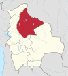
Ingavi is a province in the La Paz Department in Bolivia. This is where the Battle of Ingavi occurred on November 18, 1841 and where the World Heritage Site of Tiwanaku is situated.

Inquisivi is a province in the La Paz Department in Bolivia. During the presidency of José Ballivián it was created on November 2, 1844. The capital of the province is Inquisivi.
Muñecas is a province in the Bolivian department of La Paz. Its capital is Chuma.
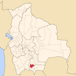
Sud Cinti is a province in the Bolivian department of Chuquisaca.

José María Avilés is a province in the western parts of the Bolivian department Tarija.
Eustaquio Méndez is a province in the north-western parts of the Bolivian department Tarija.

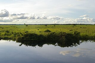
Trinidad Municipality is located in Beni Department in Bolivia.

Ichilo is one of the fifteen provinces of the Bolivian Santa Cruz Department and is situated in the department's north-western parts. The province was founded by a decree of 8 April 1926 and is named after Río Ichilo which is forming the province border in the West.

Ángel Sandoval Province is one of the fifteen provinces of the Bolivian Santa Cruz Department and is situated in the department's eastern parts.

Jesús de Machaca is a location in the La Paz Department, Bolivia. It is the seat of the Jesús de Machaca Municipality, the sixth municipal section of the Ingavi Province, and of the Jesús de Machaca Canton. In 2001 it had a population of 396.
Magdalena Municipality is the first municipal section of the Iténez Province in the Beni Department in Bolivia. Its seat is Magdalena.
Santa Ana Municipality or Santa Ana del Yacuma Municipality is a municipality of the Beni Department, Bolivia.
Chimoré Municipality is the fourth municipal section of the Carrasco Province in the Cochabamba Department, Bolivia. Its seat is Chimoré.
Pasorapa Municipality is the second municipal section of the Narciso Campero Province in the Cochabamba Department, Bolivia. Its seat is Pasorapa.
Pojo Municipality is the second municipal section of the Carrasco Province in the Cochabamba Department, Bolivia. Its seat is Pojo.
Puerto Villarroel Municipality is the fifth municipal section of the Carrasco Province in the Cochabamba Department, Bolivia. Its seat is Puerto Villarroel.

Villa Tunari Municipality is the third municipal section of the Chapare Province in the Cochabamba Department, Bolivia. Its seat is Villa Tunari. The population grew from 52,886 to 71,146 during 2001 to 2012 according to the census. Only 8,692 of the population are urban and are concentrated in the small towns of Villa Tunari (3.213), Eterazama (3,359) and Villa 14 the Septiembre (2,123). The municipality is famous for tourist especially the Villa Tunari town where the tourist industry is concentrated with infrastructure, and also because of the closeness of the Machia Park.
San Ramón is a small town in the Beni Department in Bolivia.
Tinguipaya is a small town in Bolivia, Potosí Department, Tomás Frías Province. It is the seat of the Tinguipaya Municipality.