The San Ignacio Province is one of thirteen provinces located in the Cajamarca Region of Peru. The capital of this province is the city of San Ignacio.

The Roman Catholic Archdiocese of Córdoba is in Argentina and is a metropolitan diocese and its suffragan sees include Cruz del Eje, San Francisco, Villa de la Concepción del Río Cuarto and Villa María as well as the Territorial Prelature of Deán Funes. It was elevated on 20 April 1934.

Kaluvoya or Kaluvaya is a village and a Mandal in Nellore district in the state of Andhra Pradesh in India.

Minto Park is a park in downtown Ottawa, Ontario, Canada. It occupies a full city block, meeting Elgin Street on its west side, Gilmour Street on the north, Cartier Street on the east, and Lewis Street on the south. It contains picnic benches, street lights and several monuments, including a memorial to women who were murdered and abused by men, and a bust of Argentinian general José de San Martín.
El Prado District is one of thirteen districts of the province San Miguel in Peru.
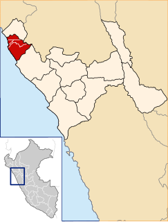
Guadalupe District is one of five districts of the province Pacasmayo in Peru.
Jequetepeque District is one of five districts of the province Pacasmayo in Peru.

Krąplewice is a village in the administrative district of Gmina Jeżewo, within Świecie County, Kuyavian-Pomeranian Voivodeship, in north-central Poland. It lies approximately 6 kilometres (4 mi) west of Jeżewo, 10 km (6 mi) north of Świecie, 51 km (32 mi) north-east of Bydgoszcz, and 54 km (34 mi) north of Toruń.

Osiny is a village in the administrative district of Gmina Siedlce, within Siedlce County, Masovian Voivodeship, in east-central Poland. It lies approximately 11 kilometres (7 mi) east of Siedlce and 97 km (60 mi) east of Warsaw.
Grabów is a village in the administrative district of Gmina Tłuszcz, within Wołomin County, Masovian Voivodeship, in east-central Poland. It lies approximately 4 kilometres (2 mi) south-east of Tłuszcz, 20 km (12 mi) east of Wołomin, and 41 km (25 mi) north-east of Warsaw.
Kury is a village in the administrative district of Gmina Tłuszcz, within Wołomin County, Masovian Voivodeship, in east-central Poland. It lies approximately 4 kilometres (2 mi) south-east of Tłuszcz, 20 km (12 mi) east of Wołomin, and 41 km (25 mi) north-east of Warsaw.
Męciszów is a village in the administrative district of Gmina Zwoleń, within Zwoleń County, Masovian Voivodeship, in east-central Poland. It lies approximately 9 kilometres (6 mi) north-west of Zwoleń and 96 km (60 mi) south of Warsaw.
San Sebastián is the eleventh district in San José Canton, Costa Rica. An important residential district, San Sebastián is the third most populated and second most densely populated in the canton.
Catacora Municipality is the second municipal section of the José Manuel Pando Province in the La Paz Department, Bolivia. Its seat is Catacora.
Jarkurgan is a raion (district) of Surxondaryo Region in Uzbekistan. The capital lies at Jarkurgan.
San Pablo Nuevo is a corregimiento in David District, Chiriquí Province, Panama. It has a land area of 59 square kilometres (23 sq mi) and had a population of 1,752 as of 2010, giving it a population density of 29.7 inhabitants per square kilometre (77/sq mi). Its population as of 1990 was 1,192; its population as of 2000 was 1,642.
Tres Quebradas is a corregimiento in Los Santos District, Los Santos Province, Panama with a population of 717 as of 2010. Its population as of 1990 was 1,646; its population as of 2000 was 665.
Guánico is a corregimiento in Tonosí District, Los Santos Province, Panama with a population of 996 as of 2010. Its population as of 1990 was 1,477; its population as of 2000 was 1,006.
Pedro González is one of the Pearl Islands of Panama. It is a corregimiento in Balboa District, Panamá Province with a population of 263 as of 2010, mostly in the village of Pedro de Cocal. Its population as of 1990 was 440; its population as of 2000 was 247.

A bronze sculpture of Argentine general José de San Martín stands in Belgrave Square, London, United Kingdom. It was unveiled on 2 November 1994 by the Duke of Edinburgh. The statue is the work of Argentinian sculptor Juan Carlos Ferraro.