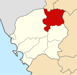
Julcán District, Julcán

Last updated
Julcán
District
Country Flag of Peru.svg  Peru
Region La Libertad
Province Julcán
Founded June 12, 1961
Capital Julcán
Government
   Mayor Diner Wilfredo Valdivieso Velarde
Area
  Total 208.49 km2 (80.50 sq mi)
Elevation 3,404 m (11,168 ft)
Population (2005 census)
  Total 15,001
  Density 72/km2 (190/sq mi)
Time zone PET (UTC-5)
UBIGEO 130501

Julcán District is one of four districts in Julcán Province in Peru. [1]

Districts of Peru third level administrative subdivision of Peru

The districts of Peru are the third-level country subdivisions of Peru. They are subdivisions of the provinces, which in turn are subdivisions of the larger regions or departments. There are 1,838 districts in total.

Julcán Province Province in La Libertad, Peru

The Julcán Province is one of twelve provinces of the La Libertad Region in Peru. The capital of this province is the city of Julcán.

Peru republic in South America

Peru, officially the Republic of Peru, is a country in western South America. It is bordered in the north by Ecuador and Colombia, in the east by Brazil, in the southeast by Bolivia, in the south by Chile, and in the west by the Pacific Ocean. Peru is a megadiverse country with habitats ranging from the arid plains of the Pacific coastal region in the west to the peaks of the Andes mountains vertically extending from the north to the southeast of the country to the tropical Amazon Basin rainforest in the east with the Amazon river.

Related Research Articles

Arctic Archipelago Canadian archipelago

The Arctic Archipelago, also known as the Canadian Arctic Archipelago, is a group of islands north of the Canadian mainland.

HMS Bullen was a Buckley class Captain class frigate during World War II. Named after Captain Charles Bullen of HMS Britannia at the battle of Trafalgar.

Bolognesi District District in Ancash, Peru

The District of Bolognesi is one of 11 districts which are part of the Pallasca Province in Ancash, Peru.

Julcán District is one of thirty-four districts of the province Jauja in Peru.

Calamarca District is one of four districts of the province Julcán in Peru.

Carabamba District is one of four districts of the province Julcán in Peru.

Huaso or Wasu (Quechua) is one of four districts of the province Julcán in Peru.

Huanchay District is one of twelve districts of the province Huaraz in Peru.

Huacaschuque District is one of eleven districts of the province Pallasca in Peru.

Llapo District is one of eleven districts of the province Pallasca in Peru.

Tauca District is one of eleven districts of the province Pallasca in Peru.

San Cristóbal de Rajan District is one of ten districts of the province Ocros in Peru.

Bambas District is one of seven districts of the province Corongo in Peru.

Macate District District in Ancash, Peru

Macate District is one of nine districts of the province Santa in Peru.

Santa District District in Ancash, Peru

Santa District is one of nine districts of the province Santa in Peru.

Buena Vista Alta District is one of four districts of the province Casma in Peru.

Luis de la Puente Uceda Peruvian activist, politician, and guerrilla

Luis Felipe de la Puente Uceda was a Peruvian activist, politician, land reformer, and guerrilla who protested against the political coexistence and coalition between his party, American Popular Revolutionary Alliance (APRA), and the conservative forces who supported the second government of Manuel Prado Ugarteche (1956-1962), and helped pioneer land reform in Peru.

Della Pia Glacier

Della Pia Glacier is a glacier that descends the east slope of Craddock Massif and flows between Mount Mohl and Elfring Peak into Thomas Glacier in the Sentinel Range, Ellsworth Mountains in Antarctica.

Ventanillas de Otuzco cultural heritage site in Peru

Ventanillas de Otuzco is a Peruvian archaeological site located in the district of Baños del Inca, 8 km northwest of the city of Cajamarca The crypts fulfilled its function of funerary enclosure.

References

Coordinates: 8°03′S78°30′W / 8.050°S 78.500°W / -8.050; -78.500

Geographic coordinate system Coordinate system

A geographic coordinate system is a coordinate system that enables every location on Earth to be specified by a set of numbers, letters or symbols. The coordinates are often chosen such that one of the numbers represents a vertical position and two or three of the numbers represent a horizontal position; alternatively, a geographic position may be expressed in a combined three-dimensional Cartesian vector. A common choice of coordinates is latitude, longitude and elevation. To specify a location on a plane requires a map projection.