
Southeast Alaska, often abbreviated to southeast or southeastern, and sometimes called the Alaska(n) panhandle, is the southeastern portion of the U.S. state of Alaska, bordered to the east and north by the northern half of the Canadian province of British Columbia. The majority of southeast Alaska is situated in Tlingit Aaní, much of which is part of the Tongass National Forest, the United States' largest national forest. In many places, the international border runs along the crest of the Boundary Ranges of the Coast Mountains. The region is noted for its scenery and mild, rainy climate.

British Columbia is the westernmost province of Canada. Situated in the Pacific Northwest between the Pacific Ocean and the Rocky Mountains, the province has a diverse geography, with rugged landscapes that include rocky coastlines, sandy beaches, forests, lakes, mountains, inland deserts and grassy plains. British Columbia borders the province of Alberta to the east; the territories of Yukon and Northwest Territories to the north; the U.S. states of Washington, Idaho and Montana to the south, and Alaska to the northwest. With an estimated population of over 5.6 million as of 2024, it is Canada's third-most populous province. The capital of British Columbia is Victoria, while the province's largest city is Vancouver. Vancouver and its suburbs together make up the third-largest metropolitan area in Canada, with the 2021 census recording 2.6 million people in Metro Vancouver. British Columbia is Canada's third-largest province in terms of total area, after Quebec and Ontario.

Vancouver Island is an island in the northeastern Pacific Ocean and part of the Canadian province of British Columbia. The island is 456 km (283 mi) in length, 100 km (62 mi) in width at its widest point, and 32,100 km2 (12,400 sq mi) in total area, while 31,285 km2 (12,079 sq mi) are of land. The island is the largest by area and the most populous along the west coasts of the Americas.
The Olympic Mountains are a mountain range on the Olympic Peninsula of the Pacific Northwest of the United States. The mountains, part of the Pacific Coast Ranges, are not especially high – Mount Olympus is the highest summit at 7,980 ft (2,432 m); however, the eastern slopes rise precipitously out of Puget Sound from sea level, and the western slopes are separated from the Pacific Ocean by the low-lying 20 to 35 km wide Pacific Ocean coastal plain. These densely forested western slopes are the wettest place in the 48 contiguous states. Most of the mountains are protected within the bounds of Olympic National Park and adjoining segments of the Olympic National Forest.
Whistler is a resort municipality in Squamish-Lillooet Regional District, British Columbia, Canada. It is located in the southern Pacific Ranges of the Coast Mountains, approximately 125 km (78 mi) north of Vancouver and 36 km (22 mi) south of Pemberton. It has a permanent population of approximately 13,982 (2021), as well as a larger but rotating population of seasonal workers.

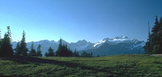
The Pacific temperate rainforests of western North America is the largest temperate rain forest region on the planet as defined by the World Wildlife Fund. The Pacific temperate rainforests lie along the western side of the Pacific Coast Ranges along the Pacific Northwest Coast of North America from the Prince William Sound in Alaska through the British Columbia Coast to Northern California, and are part of the Nearctic realm, as also defined by the World Wildlife Fund. The Pacific temperate rain forests are characterized by a high amount of rainfall, in some areas more than 300 cm (10 ft) per year and moderate temperatures in both the summer and winter months.
Picea sitchensis, the Sitka spruce, is a large, coniferous, evergreen tree growing to just over 100 meters (330 ft) tall, with a trunk diameter at breast height that can exceed 5 m (16 ft). It is by far the largest species of spruce and the fifth-largest conifer in the world, and the third-tallest conifer species. The Sitka spruce is one of only four species documented to exceed 100 m (300 ft) in height. Its name is derived from the community of Sitka in southeast Alaska, where it is prevalent. Its range hugs the western coast of Canada and the US and continues south into northern California.

British Columbia is the westernmost province of Canada, bordered by the Pacific Ocean. With an area of 944,735 km2 (364,764 sq mi) it is Canada's third-largest province. The province is almost four times the size of the United Kingdom and larger than every United States state except Alaska. It is bounded on the northwest by the U.S. state of Alaska, directly north by Yukon and the Northwest Territories, on the east by Alberta, and on the south by the U.S. states of Washington, Idaho, and Montana. Formerly part of the British Empire, the southern border of British Columbia was established by the 1846 Oregon Treaty. The province is dominated by mountain ranges, among them the Canadian Rockies but dominantly the Coast Mountains, Cassiar Mountains, and the Columbia Mountains. Most of the population is concentrated on the Pacific coast, notably in the area of Vancouver, located on the southwestern tip of the mainland, which is known as the Lower Mainland. It is the most mountainous province of Canada.

The British Columbia Coast, popularly referred to as the BC Coast or simply the Coast, is a geographic region of the Canadian province of British Columbia. As the entire western continental coastline of Canada along the Pacific Ocean is in the province, it is synonymous with being the West Coast of Canada.

Carmanah Walbran Provincial Park, originally Carmanah Pacific Provincial Park, is a remote wilderness park located inside traditional Ditidaht First Nation ancestral territory. The park covers a land area of 16,450 ha (63.5 sq mi) immediately adjacent to Pacific Rim National Park Reserve's West Coast Trail on the south-western, coastal terrain of Vancouver Island. The provincial park comprises the entire drainage of Carmanah Creek, and a good portion of the lower Walbran River drainage, both of which independently empty into the Pacific Ocean. The park is named after the Anglicized diitiid?aatx word kwaabaaduw7aa7tx, or Carmanah, meaning "as far up as a canoe can go" and John Thomas Walbran, a colonial explorer and ship's captain. Access to the park is by gravel logging road from Port Alberni, Lake Cowichan, or Port Renfrew.

Juan de Fuca Provincial Park is a provincial park located on the west coast of Vancouver Island in British Columbia, Canada. The park was established on April 4, 1996 by combining three former parks — China Beach, Loss Creek, and Botanical Beach — into one provincial park. It is the location of the majority of the Juan de Fuca Marine Trail, which is a southern compliment to the West Coast Trail within Pacific Rim National Park Reserve.

Port Renfrew is a small unincorporated community located on the south shore of Port San Juan, an inlet on the west coast of Vancouver Island in British Columbia, Canada. Port Renfrew has a population of 262 and has been touted as "the Tall Tree Capital of Canada".

The Ancient Forest Alliance is a grassroots environmental organization in British Columbia, Canada. It was founded in January 2010, and is dedicated to protecting British Columbia's old-growth forests in areas where they are scarce, and ensuring sustainable forestry jobs in that province.
The Central Pacific coastal forests is a temperate coniferous forest ecoregion located in the Canadian province of British Columbia and the U.S. states of Oregon and Washington, as defined by the World Wildlife Fund (WWF) categorization system.

San Juan River is a river that flows from east to west through southern Vancouver Island in British Columbia, Canada. The river originates in the Seymour Range, flows westward through the San Juan Valley to Port San Juan at Port Renfrew.

Picea × lutzii is a hybrid spruce tree that is a natural cross between white spruce and Sitka spruce occurring where the ranges of the two species overlap in coastal south-central Alaska and coastal British Columbia. Its common name is Lutz spruce. Its morphology is intermediate between the two parent species, the maritime Sitka spruce and the white spruce of dryer climates further inland. In addition to the parent spruces it shares its ecosystem with Tsuga heterophylla and T. mertensiana. The tree was named for Harold John Lutz, a scientist who specialized in forest soils and worked briefly for the United States Forest Service in Alaska where he collected the material used to describe the hybrid. A Lutz spruce from Alaska's Chugach National Forest was selected in 2015 for the Capitol Christmas Tree. This is the first Capitol Tree that has come from the state of Alaska.
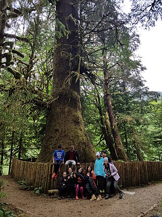
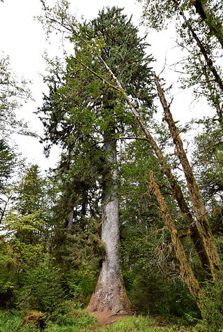
The Harris Creek Sitka Spruce is a large Sitka spruce tree, about 4 metres (13 ft) in diameter, near the creek bed of Harris Creek, off the Pacific Marine Road between Port Renfrew, BC and Honeymoon Bay, BC on Vancouver Island, in British Columbia. Although it is not the largest sitka spruce on Vancouver Island, it is easily accessible and has become a famous tree along the Pacific Marine Loop going from Victoria, BC, through Port Renfrew, Lake Cowichan, and Duncan, BC and returning to Victoria over the Malahat Drive. It is approximately 80 metres (260 ft) tall.

The Red Creek Fir is a large Douglas fir tree located in the San Juan Valley of Vancouver Island in British Columbia, Canada. By volume, it is the largest known Douglas fir tree on Earth.
The San Juan Valley is a small valley located in the Capital Regional District of Vancouver Island in British Columbia, Canada.
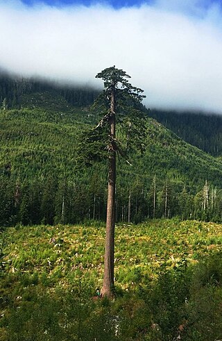
Big Lonely Doug is a large Coast Douglas-fir tree located in the Gordon River Valley, 10km north of Port Renfrew on Vancouver Island, British Columbia, Canada. It is the second largest Douglas-fir tree in Canada after the Red Creek Fir in nearby San Juan Valley.

