
Oceanside is a beach city in the North County area of San Diego County, California. The city had a population of 174,068 at the 2020 United States census, up from 167,086 at the 2010 census, making it the most populous city in the North County region of San Diego. The city is a popular tourist destination, owing to its historic landmarks, beaches, and architecture.

The main segment of the Los Gatos Creek Trail is a 9.7-mile (15.6 km) pedestrian and bicycle trail that runs through western Santa Clara County in California. It runs from Lexington Reservoir in Los Gatos, California through Campbell, California to Meridian Avenue in San Jose, California alongside Los Gatos Creek.

The Mount Vernon Trail (MVT) is an 18-mile (29 km) long shared use path that travels along the George Washington Memorial Parkway in Northern Virginia between Rosslyn and George Washington's home at Mount Vernon. The trail connects the easternmost portions of Arlington County, the City of Alexandria, and Fairfax County, and travels mostly on dedicated trail with a small portion on city streets. As part of U.S. Bike Route 1, the Potomac Heritage Trail and the East Coast Greenway, the MVT opened in April 1972 as a gravel path and was subsequently expanded and paved.
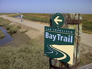
The San Francisco Bay Trail is a bicycle and pedestrian trail that when finished will allow continuous travel around the shoreline of San Francisco Bay. As of 2020, 356 miles (573 km) of the trail have been completed. When finished, the trail will be over 500 miles (800 km) of paved and gravel paths, bike lanes, and sidewalks, linking 47 cities across nine counties and crossing seven toll bridges. It is a project of the Association of Bay Area Governments (ABAG) and the Metropolitan Transportation Commission (MTC), in collaboration with other agencies, private companies, non-profit organizations, and advocacy groups.

The Marvin Braude Bike Trail is a 22-mile (35 km) paved bicycle path that runs mostly along the shoreline of Santa Monica Bay in Los Angeles County, California. The coastal bike trail is widely acknowledged as Los Angeles' "most popular bike path."
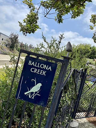
The Ballona Creek Bike Path is a 6.7-mile (10.8 km) Class I bicycle path and pedestrian route in California. The bike path follows the north bank of Ballona Creek until it reaches Santa Monica Bay at the Pacific Ocean. The route is defined by, and recognized for, the dramatic contrast between the channelized waterway’s stark cement geometry and the abundant wildlife of the verdant Ballona Wetlands.
The Santa Clara River Trail is a paved bicycle and walking path in the city of Santa Clarita, California.

People in the San Francisco Bay Area rely on a complex multimodal transportation infrastructure consisting of roads, bridges, highways, rail, tunnels, airports, seaports, and bike and pedestrian paths. The development, maintenance, and operation of these different modes of transportation are overseen by various agencies, including the California Department of Transportation (Caltrans), the Association of Bay Area Governments, San Francisco Municipal Transportation Agency, and the Metropolitan Transportation Commission. These and other organizations collectively manage several interstate highways and state routes, eight passenger rail networks, eight trans-bay bridges, transbay ferry service, local and transbay bus service, three international airports, and an extensive network of roads, tunnels, and bike paths.

The San Luis Rey River is a river in northern San Diego County, California.

A large metropolitan area that is surrounded by rivers and hills, Pittsburgh has an infrastructure system that has been built out over the years to include roads, tunnels, bridges, railroads, inclines, bike paths, and stairways; however, the hills and rivers still form many barriers to transportation within the city.

The following is a list of transportation options in San Diego County, California.
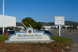
Oceanside Municipal Airport, also known as the Bob Maxwell Memorial Field, is a public airport in Oceanside, California, United States. It is located two miles (3 km) northeast of the downtown Oceanside, between California State Route 76 and the San Luis Rey River bike path. The airport covers 43 acres (170,000 m2) and has one runway. It is mostly used for general aviation. The airport is operated and managed by Airport Property Ventures.
The Culver Boulevard Median Bike Path is Class I rail trail bicycle path, walk route and linear park on Culver Boulevard in western Los Angeles County, California.

The Los Angeles River bicycle path is a Class I bicycle and pedestrian path in the Greater Los Angeles area running from north to east along the Los Angeles River through Griffith Park in an area known as the Glendale Narrows. The 7.4 mile section of bikeway through the Glendale Narrows is known as the Elysian Valley Bicycle & Pedestrian Path. The bike path also runs from the city of Vernon to Long Beach, California. This section is referred to as LARIO, or more formally, the Los Angeles River Bikeway.

Minneapolis is often considered one of the top biking and walking cities in the United States due to its vast network of trails and dedicated pedestrian areas. In 2020, Walk Score rated Minneapolis as 13th highest among cities over 200,000 people. Some bicycling ratings list Minneapolis at the top of all United States cities, while others list Minneapolis in the top ten. There are over 80 miles (130 km) of paved, protected pathways in Minneapolis for use as transportation and recreation. The city's Grand Rounds National Scenic Byway parkway system accounts for the vast majority of the city's shared-use paths at approximately 50 miles (80 km) of dedicated biking and walking areas. By 2008, other city, county, and park board areas accounted for approximately 30 miles (48 km) of additional trails, for a city-wide total of approximately 80 miles (130 km) of protected pathways. The network of shared biking and walking paths continued to grow into the late 2010s with the additions of the Hiawatha LRT Trail gap remediation, Min Hi Line pilot projects, and Samatar Crossing. The city also features several natural-surface hiking trails, mountain-biking paths, groomed cross-country ski trails in winter, and other pedestrian walkways.
