San Pedro de Larcay District

Last updated
San Pedro de Larcay
Larq'ay
District

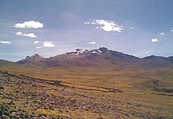
Ccarhuarazo.jpg

Location of the district San Pedro de Larcay in Sucre.svg
Location of San Pedro de Larcay in the Sucre province
Country Flag of Peru.svg  Peru
Region Ayacucho
Province Sucre
Founded July 8, 1964
Capital San Pedro de Larcay
Subdivisions 25 populated places
Area
  Total 310.07 km2 (119.72 sq mi)
Elevation 3,376 m (11,076 ft)
Population (2005 census)
  Total 1,175
  Density 3.8/km2 (9.8/sq mi)
Time zone PET (UTC-5)
UBIGEO 050908
Website cuspel.pe/es/sanpedrodelarcay

San Pedro de Larcay is one of 11 districts of the Sucre Province in the Ayacucho region in Peru.

Districts of Peru third level administrative subdivision of Peru

The districts of Peru are the third-level country subdivisions of Peru. They are subdivisions of the provinces, which in turn are subdivisions of the larger regions or departments. There are 1,838 districts in total.

Sucre Province Province in Ayacucho, Peru

Sucre Province is a province in the eastern part of the Ayacucho Region in Peru.

Ayacucho Region Region in 11 provinces and 111 districts, Peru

Ayacucho is a region of Peru, located in the south-central Andes of the country. Its capital is the city of Ayacucho. The region was one of the hardest hit by terrorism in the 1980s during the guerrilla war waged by Shining Path known as the internal conflict in Peru.

Contents

Administrative division

The populated places in the district are: [1]

Population

The population of San Pedro de Larcay (2005 census) is 1,175 people, 600 men and 575 women. [1]

See also

Related Research Articles

Lucanas Province Province in Ayacucho, Peru

Lucanas is the largest province in the Ayacucho Region in Peru. Its seat is Puquio.

San Salvador de Quije District District in Ayacucho, Peru

San Salvador de Quije is one of 11 districts of the Sucre Province in the Ayacucho region in Peru.

Soras District District in Ayacucho, Peru

Soras is one of 11 districts of the Sucre Province in the Ayacucho region in Peru.

Aucara District District in Ayacucho, Peru

Aucará District is one of twenty-one districts of the Lucanas Province in Peru.

Cabana District is one of twenty-one districts of the province Lucanas in Peru.

Laramate District is one of twenty-one districts of the province Lucanas in Peru.

Leoncio Prado District is one of twenty-one districts of the province Lucanas in Peru.

Llauta District is one of twenty-one districts of the Lucanas Province in Peru.

Otoca District is one of twenty-one districts of the Lucanas Province in Peru.

Puquio District is one of twenty-one districts of the Lucanas Province in Peru.

San Cristóbal District is one of twenty-one districts of the province Lucanas in Peru.

San Juan District, Lucanas District in Ayacucho, Peru

San Juan District is one of twenty-one districts of the province Lucanas in Peru.

San Pedro de Palco District is one of twenty-one districts of the Lucanas Province in Peru.

San Pedro District, Lucanas District in Ayacucho, Peru

San Pedro District is one of twenty-one districts of the province Lucanas in Peru.

Santa Lucía District is one of twenty-one districts of the province Lucanas in Peru.

Upahuacho District is one of eight districts of the Parinacochas Province in Peru.

San Francisco de Rivacayco District is one of eight districts of the province Parinacochas in Peru.

Coronel Castañeda District is one of eight districts of the Parinacochas Province in Peru.

Chumpi District is one of eight districts of the Parinacochas Province in Peru.

References

  1. 1 2 INEI Archived 2007-06-01 at the Wayback Machine .

Coordinates: 14°41′38″S74°07′27″W / 14.69389°S 74.12417°W / -14.69389; -74.12417

Geographic coordinate system Coordinate system

A geographic coordinate system is a coordinate system that enables every location on Earth to be specified by a set of numbers, letters or symbols. The coordinates are often chosen such that one of the numbers represents a vertical position and two or three of the numbers represent a horizontal position; alternatively, a geographic position may be expressed in a combined three-dimensional Cartesian vector. A common choice of coordinates is latitude, longitude and elevation. To specify a location on a plane requires a map projection.