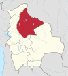
Potosí is a department in southwestern Bolivia. It comprises 118,218 km² with 823,517 inhabitants. The capital is the city of Potosí. It is mostly a barren, mountainous region with one large plateau to the west, where the largest salt flat in the world, Salar de Uyuni, is located.
Sörberge is a village in Timrå Municipality, Sweden.
Cáseda is a town and municipality located in the province and autonomous community of Navarre, northern Spain.

El Alto is a municipality and the second-largest city in Bolivia, located adjacent to La Paz in Pedro Domingo Murillo Province on the Altiplano highlands. El Alto is today one of Bolivia's fastest-growing urban centers, with a population of 974,754 in 2011. El Alto is the highest major metropolis in the world, with an average elevation of 4,150 m (13,615 ft).

Cerratón de Juarros is a municipality located in the province of Burgos, Castile and León, Spain. According to the 2004 census (INE), the municipality has a population of 62 inhabitants.
Manuel María Caballero Province is one of the fifteen provinces of the Bolivian Santa Cruz Department and is situated in the department's western parts. The province name honors deputy Manuel María Caballero from Vallegrande, one of the signatories of the Bolivian constitution of 5 August 1861.
Cairoma Municipality is the fifth municipal section of the Loayza Province in the La Paz Department, Bolivia. Its seat is Cairoma.
Cajuata Municipality is the third municipal section of the Inquisivi Province in the La Paz Department, Bolivia. Its seat is Cajuata.

Collana Municipality is the seventh municipal section of the Aroma Province in the La Paz Department, Bolivia. Its seat is Collana.

Irupana Municipality or Villa de Lanza Municipality is the second municipal section of the Sud Yungas Province in the La Paz Department, Bolivia. Its seat is Irupana.
Licoma Pampa Municipality is the sixth municipal section of the Inquisivi Province in the La Paz Department, Bolivia. Its seat is Licoma.

Yanacachi Municipality is the third municipal section of the Sud Yungas Province in the La Paz Department, Bolivia. Its seat is Yanacachi.
Colquencha is a town in Aroma Province in the La Paz Department, Bolivia. It is the seat of the Colquencha Municipality.
Mocomoco or Muqu Muqu (Aymara) is a location in the La Paz Department in Bolivia. It is the seat of the Mocomoco Municipality in the Eliodoro Camacho Province.
La Asunta Municipality is the fifth municipal section of the Sud Yungas Province in the La Paz Department, Bolivia. Its seat is La Asunta.
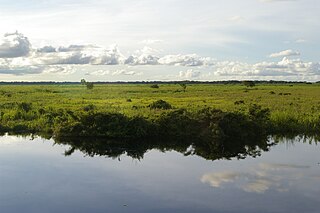
Baures Municipality is a municipality of the Beni Department, Bolivia.
Morochata Municipality is the second municipal section of the Ayopaya Province in the Cochabamba Department, Bolivia. Its seat is Morochata.
Santiago de Andamarca is a small location in Bolivia in the Oruro Department, Sud Carangas Province. It is the seat of the Santiago de Andamarca Municipality. In 2010 the village had an estimated population of 374.

Somers Glacier is a glacier flowing northwest into Trooz Glacier on Kiev Peninsula, the west coast of Graham Land. First charted by the British Graham Land Expedition (BGLE) under Rymill, 1934-37. Named by the United Kingdom Antarctic Place-Names Committee (UK-APC) in 1959 for Henri Somers, chief engineer of the BelgAE's ship Belgica, which explored in the area in 1897-99.