
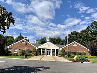
Flower Hill is a village in Nassau County, on the North Shore of Long Island, in New York, United States. The eastern half is considered part of the Greater Roslyn area, which is anchored by the Incorporated Village of Roslyn. Western and northern parts are more closely associated with Manhasset and Port Washington. The population was 4,794 at the time of the 2020 census.

Munsey Park is a village in Nassau County, on the North Shore of Long Island, in New York, United States. It is considered part of the Greater Manhasset area, which is anchored by Manhasset. The population was 2,809 at the 2020 census.
North Hills is a village in the Town of North Hempstead in Nassau County, on the North Shore of Long Island, in New York, United States. The population was 5,464 at the 2020 census.
Roslyn Estates is a village in the Town of North Hempstead in Nassau County, on the North Shore of Long Island, in New York, United States. It is considered part of the Greater Roslyn area, which is anchored by the Incorporated Village of Roslyn. The population was 1,318 at the 2020 census.

Dix Hills is a hamlet and census-designated place (CDP) on Long Island in the town of Huntington in Suffolk County, New York. The population was 26,180 at the 2020 census.

South Huntington is a hamlet and census-designated place (CDP) within the Town of Huntington in Suffolk County, on Long Island, in New York, United States. The population was 9,422 at the 2010 census. Residents have a Huntington Station postal address.

The Town of Huntington is one of ten towns in Suffolk County, New York. Founded in 1653, it is located on the north shore of Long Island in northwestern Suffolk County, with Long Island Sound to its north and Nassau County adjacent to the west. Huntington is part of the New York metropolitan area. As of the 2020 census, the town population was 204,127.

Smithtown is a town in Suffolk County, New York, on the North Shore of Long Island. It is part of the New York metropolitan area. The population was 116,296 at the 2020 Census.

Fresh Meadows is a neighborhood in the northeastern section of the New York City borough of Queens. Fresh Meadows used to be part of the broader town of Flushing and is bordered to the north by the Horace Harding Expressway; to the west by Pomonok, St. John's University and the sub-neighborhoods of Hillcrest and Utopia; to the east by Cunningham Park and the Clearview Expressway; and to the south by the Grand Central Parkway.

New York State Route 25A (NY 25A) is a state highway on Long Island in New York, United States. It serves as the main east–west route for most of the North Shore of Long Island, running for 73 miles (117 km) from Interstate 495 (I-495) at the Queens–Midtown Tunnel in the New York City borough of Queens to NY 25 in Calverton, Suffolk County. The highway is a northern alternate route of NY 25, which follows a more inland routing along Jericho Turnpike.

New York State Route 25 (NY 25) is an east–west state highway in downstate New York in the United States. The route extends for just over 105 miles (169 km) from east midtown Manhattan in New York City to the Cross Sound Ferry terminal at Orient Point on the end of Long Island's North Fork. NY 25 is carried from Manhattan to Queens by way of the double-decked Queensboro Bridge over the East River.
Half Hollow Hills Central School District (#5) is located in Dix Hills, New York, on Long Island, and primarily serves the hamlets of Dix Hills and Melville, while also serving parts of East Farmingdale, Deer Park, West Hills, East Northport, and Wheatley Heights in Suffolk County. Nine schools comprise the school district.

New York State Route 347 (NY 347) is an east–west expressway located in Suffolk County, New York, in the United States. It connects the Northern State Parkway in Hauppauge to NY 25A in Mount Sinai. The route serves as a southern bypass of Smithtown and as a direct link between Nesconset and Port Jefferson. Along the way, NY 347 intersects NY 25 in Nesconset and Nicolls Road in Lake Grove. The westernmost 2 miles (3.2 km) of NY 347 is concurrent with NY 454 while the portion northeast of NY 25 parallels NY 25A, which follows a more northerly alignment through the town of Brookhaven than NY 347.
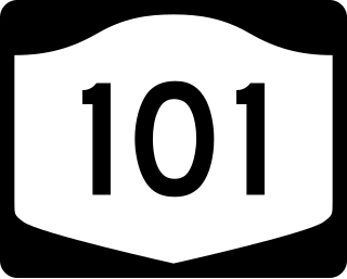
New York State Route 101 (NY 101) is a 3.58-mile (5.76 km) long state highway in northwestern Nassau County, New York, in the United States. It runs north–south as Port Washington Boulevard from NY 25A in Flower Hill, west of Roslyn and east of Manhasset, to Astor Lane in Sands Point. It becomes County Route 101 (CR 101) south along Searingtown Road to Shelter Rock Road (CR 8) and becomes Middle Neck Road north of Astor Lane, continuing north and west to a dead end at the Long Island Sound as the unsigned County Route D55 (CR D55).

The Roslyn-Flower Hill Elementary School was a local, public elementary school located within the Incorporated Village of Flower Hill, in Nassau County, New York. It was operated by the Roslyn Union Free School District.

The Reconstructionist Synagogue of the North Shore is a Reconstructionist Jewish synagogue located in the Incorporated Village of Plandome in the Town of North Hempstead, in Nassau County, on the North Shore of Long Island, in New York, United States.

Strathmore is an unincorporated, Levitt & Sons-developed hamlet in the Town of North Hempstead in Nassau County, on the North Shore of Long Island, in New York, United States, within the census-designated place (CDP) of Manhasset.

The Great Neck Park District is a park district serving much of the Great Neck Peninsula of Nassau County, Long Island, New York, United States. It is the oldest park district in the State of New York and is headquartered a 5 Beach Road, Great Neck, New York 11024.

The Manhasset Park District is a park district serving much of the Greater Manhasset area of Nassau County, Long Island, New York, United States. It is headquartered a 62 Manhasset Avenue, Manhasset, NY 11030.

Manhasset Woods Road is a 1.16-mile (1.87 km) road in the incorporated villages of Flower Hill and Munsey Park in the Town of North Hempstead, in Nassau County, on the North Shore of Long Island, in New York, United States. It serves as a major north–south through street across the lower portion of the Cow Neck Peninsula, between Northern Boulevard to the south and Stonytown Road to the north.

