Related Research Articles
The Ohio Range is a range in the Transantarctic Mountains of Antarctica. It is about 30 nautical miles long and 10 nautical miles wide, extending west-southwest – east-northeast from Eldridge Peak to Mirsky Ledge. The range forms the northeast end of the Horlick Mountains and consists primarily of a large snow-topped plateau with steep northern cliffs and several flat-topped ridges and mountains. The highest point, 2,990 metres (9,810 ft), is the summit of Mount Schopf.
Hope Bay is a bay 3 nautical miles long and 2 nautical miles wide, indenting the tip of the Antarctic Peninsula and opening on Antarctic Sound.

Jason was a Norwegian whaling vessel laid down in 1881 by Rødsverven in Sandefjord, Norway, the same shipyard which later built Ernest Shackleton's ship Endurance. The ship, financed by Christen Christensen, an entrepreneur from Sandefjord, was noted for his participation in an 1892–1893 Antarctic expedition led by Carl Anton Larsen.
The Land Glacier is a broad, heavily crevassed glacier, about 35 nautical miles long, descending into Land Bay in Marie Byrd Land, Antarctica. It was discovered by the United States Antarctic Service (1939–41) and named for Rear Admiral Emory S. Land, Chairman of the United States Maritime Commission.
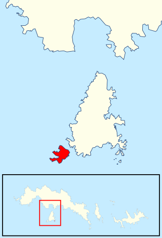
Andreaea Plateau is a small plateau with an average elevation of 180 metres (590 ft), located southwest of Robin Peak, Signy Island, in the South Orkney Islands. The feature is notable for the largest known stand in the Antarctic of the black-brown moss Andreaea.

Cheal Point is a rocky headland 2 km (1.2 mi) east-south-east of Return Point, the south-western extremity of Coronation Island, in the South Orkney Islands of Antarctica.
Coldblow Col is a snow-covered col at 300 metres (1,000 ft) elevation, between Echo Mountain and the Cragsman Peaks on Coronation Island, in the South Orkney Islands. It was surveyed in 1950 by the Falkland Islands Dependencies Survey (FIDS). The name derives from the fact that a FIDS party had their tent blown down in a gale when camped on this col in September 1948.
Condor Peninsula is a mountainous, ice-covered peninsula, 30 nautical miles long and 10 to 15 nautical miles wide, between Odom Inlet and Hilton Inlet on the east coast of Palmer Land, Antarctica.
Wave Peak is a conspicuous peak, 960 m, which rises precipitously from the head of Laws Glacier in the central part of Coronation Island, in the South Orkney Islands. The feature has a prominent ridge running in a southwesterly direction. To the north and east it slopes gently to the level of Brisbane Heights. Surveyed in 1948-49 by the Falkland Islands Dependencies Survey (FIDS), and so named by them because of the resemblance of this peak to a wave about to break.
Pomona Plateau is an ice-covered plateau, over 300 metres (980 ft) elevation, extending between Sandefjord Peaks and Deacon Hill in the western part of Coronation Island, in the South Orkney Islands. Named by the United Kingdom Antarctic Place-Names Committee (UK-APC) following a survey by the Falkland Islands Dependencies Survey (FIDS) in 1948–50. This naming revives in an altered form a name given by James Weddell in 1822. Being unaware of the prior discovery of Coronation Island by Captain Nathaniel Palmer and Captain George Powell, and its naming at that time, Weddell renamed the island "Pomona" or "Mainland" after the island in the northern Orkney Islands. That name was published by Weddell in 1825 but did not survive.
The Edgeworth Glacier is a glacier 12 nautical miles long, flowing south-southwestwards from the edge of Detroit Plateau below Wolseley Buttress to the ice shelf west of Sobral Peninsula, Graham Land, Antarctica.

Ferguslie Peninsula is a peninsula 2.4 km (1.5 mi) long, lying between Browns Bay and Macdougal Bay on the north coast of Laurie Island, in the South Orkney Islands of Antarctica. The peninsula was charted in 1903 by the Scottish National Antarctic Expedition under William Speirs Bruce, who named it for Ferguslie, the residence of James Coats, chief patron of the expedition.
Mobiloil Inlet is an ice-filled inlet, nurtured by several northeast and east flowing glaciers, lying between the Rock Pile Peaks and Hollick-Kenyon Peninsula along the east coast of the Antarctic Peninsula.
Moe Island is an island 2 km (1.2 mi) long in the South Orkney Islands off Antarctica, separated from the south-west end of Signy Island by Fyr Channel. It was charted by Captain Petter Sørlle in 1912–13, and named after M. Thoralf Moe of Sandefjord, Norway, a contemporary whaling captain who worked in this area. The northernmost point of the island is Spaull Point, named by United Kingdom Antarctic Place-Names Committee (UK-APC) after Vaughan W. Spaull, British Antarctic Survey (BAS) biologist on Signy Island, 1969.
The Moss Braes are west-facing slopes situated west of Robin Peak on Signy Island, in the South Orkney Islands off Antarctica. They were named by the UK Antarctic Place-Names Committee in 1990 from the extensive moss banks on the dissected rocky slopes.
The Medina Peaks are rugged, mainly ice-free, peaks surmounting a ridge 15 nautical miles long, extending north along the east side of Goodale Glacier to the edge of the Ross Ice Shelf, Antarctica.
Robin Peak is a sharply defined rocky summit which is the northernmost peak on Signy Island in the South Orkney Islands. It was named by the United Kingdom Antarctic Place-Names Committee (UK-APC) in 1954 for Gordon de Quetteville Robin of the Falkland Islands Dependencies Survey (FIDS), the leader at Signy Island base in 1947, who made the first detailed survey of the island.

Sowers Glacier is a glacier that flows from the prominent cirque on the east side of Craddock Massif and continues between Willis Ridge on the north, and Sanchez Peak and Stolnik Peak on the south, to join Thomas Glacier north of Mount Osborne, in the Sentinel Range, Ellsworth Mountains in Antarctica.
Three Lakes Valley is a low valley containing three freshwater lakes, extending from the vicinity of Elephant Flats northward to Stygian Cove on Signy Island, in the South Orkney Islands. The three lakes, from north to south, are Heywood Lake, Knob Lake, and Pumphouse Lake. The valley was surveyed and given this descriptive name by the Falkland Islands Dependencies Survey (FIDS) in 1947.
Sandefjord Bay is a narrow body of water on the west coast of Coronation Island in the South Orkney Islands of Antarctica. It is 2 mi (3.2 km) long and extends in a northeast-southwest direction between Coronation Island and Monroe Island.
References
- ↑ Gildea, Damien(2010). “Mountaineering in Antarctica:Climbing in the Frozen South”, p 51 Editions Nevicata, Brussels. ISBN 978-2-87523-006-5
![]() This article incorporates public domain material from "Sandefjord Peaks". Geographic Names Information System . United States Geological Survey.
This article incorporates public domain material from "Sandefjord Peaks". Geographic Names Information System . United States Geological Survey.
| | This South Orkney Islands location article is a stub. You can help Wikipedia by expanding it. |