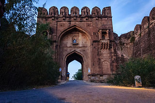
Jhelum District, is partially in Pothohar Plateau, and partially in Punjab Plain of the Punjab province of Pakistan. Jhelum is one of the oldest districts of Punjab. It was established on 23 March 1849. Jhelum is known for providing many soldiers to the British and later to the Pakistan armed forces due to which it is also known as 'city of soldiers' or 'land of martyrs and warriors'. The district of Jhelum stretches from the river Jhelum almost to the Indus. Salt is quarried at the Mayo mine in the Salt Range. There are two coal mines in the district from which the North-Western railway obtains parts of its supply. These are the only coal mines in Punjab province which are in working condition. The chief center of the salt trade is Pind Dadan Khan. The district is crossed by the main line of the North-Western railway and also traversed along the south by a branch line. It is located in the north of the Punjab province, Jhelum district is bordered by Sargodha and Mandi Bahauddin to its south, Khushab to its southwest, Jhelum River to its south and east, Gujrat to its east, Chakwal to its west, Mirpur to its northeast, and Rawalpindi to its north.

The Jhelum River is a river in the northern Indian subcontinent. It originates at Verinag and flows through the Indian-administered territory of Jammu and Kashmir, into Pakistan-administered Azad Kashmir, then the Pakistani province of Punjab. It is the westernmost of the five rivers of the Punjab region, and flows through the Kashmir Valley. It is a tributary of the Chenab River and has a total length of about 725 kilometres (450 mi).

Mangla is a town situated in District Mirpur within the region of Azad Kashmir. The village is located in the west of the foothills of Mangla's fort. It is surrounded on three sides by the semicurvature of river Jhelum flowing North to South. It is bordered with Jhelum district and with the right bank of Mangla between the State of Azad Kashmir and Punjab province of Pakistan.
Jhelum is a city on the West Bank of the Jhelum River, which is located in the district of Jhelum in the North of Punjab, Pakistan. It is the 44th largest city of Pakistan by population. Jhelum is known for providing many soldiers to the British Army before independence, and later to the Pakistan armed forces, due to which it is also known as City of Soldiers or Land of Martyrs and Warriors.
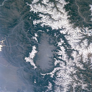
The Kashmir Valley, also known as the Vale of Kashmir, is an intermontane valley in northern Jammu and Kashmir, a region in the disputed Indian-administered Kashmir. The valley is surrounded by ranges of the Himalayas, bounded on the southwest by the Pir Panjal Range and on the northeast by the Greater Himalayan range. It is approximately 135 km (84 mi) long and 32 km (20 mi) wide, and drained by the Jhelum River. It forms the bulk of the Kashmir Division of Jammu and Kashmir.

The Neelum River, or Kishanganga River, is a river in the Kashmir region in the Indian subcontinent. It originates in Ganderbal district of Indian-administered Kashmir, flows through the Neelam Valley into Pakistani-administered Kashmir, where parts of its course fall along the Line of Control, before merging with the Jhelum River near the city of Muzaffarabad.

Awantipora or Avantipur or Aavantipur, known as Woontpor in Kashmiri, is a town, just opposite of Pulwama city, on the banks of the river Jhelum in the Pulwama district of Jammu and Kashmir, India.

Bijbehara (Urdu pronunciation:[biːd͡ʒbɪɦɑːɽɑː], known as Vejibror in Kashmiri, is a town and a notified area committee in Anantnag district of the Indian administered union territory of Jammu and Kashmir. It is located on NH 44, and jehlum bank. Bijbehara town is also known as "Town of Chinars" because of a number of Chinars there especially two Chinar gardens. Bijbehara is the home to oldest chinar tree in the region. The town is situated about 45 km from the summer capital of union territory of Jammu and Kashmir, Srinagar.

Verinag is a town named after and famous for the Verinag spring and Mughal garden, near Anantnag city in the Anantnag district of the union territory of Jammu and Kashmir, India. It is also called "gateway of Kashmir" and is a notified area committee with tehsil status and is about 26 kilometers away from Anantnag and approximately 78 kilometres south-east from Srinagar which is the summer capital of the union territory of Jammu and Kashmir. Verinag is also the first tourist spot of Kashmir Valley when travelling by road from Jammu, the winter capital of the union territory of Jammu and Kashmir towards Srinagar. There is an octagonal stone basin at Verinag Spring and an arcade surrounding it which were built by Mughal emperor Jahangir in 1620 A.D. Later, a beautiful garden next to this spring, was laid out by his son Shah Jahan. This spring is known to never dry up or overflow. Verinag Spring is also the major source of river Jhelum. Verinag Spring and Mughal Arcade surrounding it is officially recognized by Archaeological Survey of India as a Monument of National Importance.

Qazigund, also known as Gateway Of Kashmir, is a town and in the union territory of Jammu and Kashmir, India. Qazigund is located at 33.59°N 75.16°E. It has an average elevation of 1670 m (5478 feet) above mean sea level.

Poonch, is a town and the administrative headquarters of the Poonch district, of the Indian-administered union territory of Jammu and Kashmir, which is part of the larger disputed territory of Kashmir. It is located near the Line of Control – the de facto border in the disputed region. Poonch shares a de facto border with the Poonch district of the Pakistan-administered, self-governing territory of Azad Kashmir.
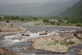
The Poonch River is a tributary of the Jhelum River that flows through Jammu and Kashmir in India, and Jammu and Kashmir in Pakistan.
The Kishanganga Hydroelectric Project is a run-of-the-river hydroelectric scheme in Jammu and Kashmir, India. Its dam diverts water from the Kishanganga River to a power plant in the Jhelum River basin. It is located near Dharmahama Village, 5 km (3 mi) north of Bandipore in the Kashmir valley and has an installed capacity of 330 MW.
Khanabal is a small town located in Anantnag District's Anantnag City. The main National Highway of Kashmir passes through it. It is the center for Anantnag City's Railway Station. Khanabal is situated on both banks of the Jehlum River. The part on the western bank is called Dak Banglow Khanabal, and the part on the eastern bank is called Khanabal Bazaar. The oldest college of the district, Govt. Degree College, Anantnag, is situated on the western bank of the Jehlum River near Dak Banglow Khanabal. Besides, Dak Banglow is an army cantonment area and has a housing colony for the district administrative officers of the police. The district police lines and the office of SSP Anantnag is also situated at Khanabal. Besides the college, Khanabal has a Govt. Higher Secondary School and an army goodwill school run by the Indian Army.

The Lidder or Liddar is a 73 km (45 mi) river situated in the Kashmir Valley of Jammu and Kashmir, India. It originates from the Kolahoi Glacier and feeds the Jhelum River in Mirgund Khanabal, at an altitude of 1,615 metres (5,299 ft).

Fatehpora also known as Fateh Pora & Fatehpura, is an economic hub area of Anantnag district in the union territory of Jammu and Kashmir, India. Fatehpora is located at 33.656027°N 75.160375°E. It has an average elevation of 1652 metres (5419 feet) above mean sea level.
Haji(Hanji) Danter is a village in Anantnag tehsil in Anantnag district in Jammu and Kashmir, India. It is adjacent to Anantnag town, just 1.5 kms away from lalchowk Anantnag and nearest village to District Headquarters. The approaches to the village are through Achabal Adda, Khanabal chowk and Naid khunoo Harnaag. The village is surrounded by all the three main tributaries of River Jhelum of Kashmir, The Brengi, The Aarpath, The Saandran. The village used to be main business hub in early times, because of developed water transport. The place has a port in its surroundings called Ghaat-e- Pushwara. The place had the first automatic hydral grinding machine called jindra, where people from far away places used to come to get their rice, wheat and spices ground.
The Bringhi or Brengi river is a river in Anantnag, Jammu and Kashmir, India. It flows for a total of 30 kilometres (19 mi) before feeding Jhelum River at Haji Danter, Anantnag. It is formed by the confluence of three streams Nowbugh stream, Ahlan Gadol Stream, and Daksum Stream. Nowbugh Stream originates from the glaciers of Margan Top, Daksum Stream originates from the glaciers of Sinthan in Anantnag district. The river passes through a gorge at Daksum. Kokernag is in the Bringhi river valley. It is one of the tributary of river Jhelum. Sir Walter Lawrence wrote in his book The Valley of Kashmir that the brang river which disappears at Dewalgam village in the fissures of the limestone is the real source of the Achabal spring. Recently a sink hole appeared in the river at wandevelgam which sucked in the whole flow of the water. This is the second time a sink hole has appeared in this river.
Maisum or Maisuma is a densely populated neighborhood of Srinagar in the Indian union territory of Jammu and Kashmir which is bordered on the north by Gawkadal bridge and on the South by Lal Chowk. River Jhelum forms it western border.
Seer Hamdan is a town in the Anantnag district of Jammu and Kashmir in India. It has a population of 20,233 people.
