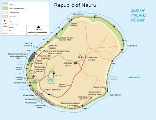
Nauru is a tiny phosphate rock island nation located in the South Pacific Ocean south of the Marshall Islands in Oceania. It is only 53 kilometres (33 mi) south of the Equator at coordinates 0°32′S166°55′E. Nauru is one of the three great phosphate rock islands in the Pacific Ocean—the others are Banaba in Kiribati and Makatea in French Polynesia.
METAR is a format for reporting weather information. A METAR weather report is predominantly used by aircraft pilots, and by meteorologists, who use aggregated METAR information to assist in weather forecasting.
Andros Town Airport or Andros Town International Airport is an airport serving Andros Town on Andros Island in the Bahamas. It is also known as Fresh Creek Airport.

Kadapa Airport is a regional airport serving Kadapa in Andhra Pradesh, India. It is located 12 km (7.5 mi) from the city, and is spread over 669.5 acres (270.9 ha) of land and has been upgraded at a cost of Rs. 42 crore. The upgraded airport was inaugurated on 7 June 2015 by the then Minister of Civil Aviation, Ashok Gajapathi Raju. The terminal building has a capacity to handle 100 peak hour passengers at a time and the apron can accommodate two ATR-72 aircraft.

Iskandar Airport is a military type-C airport in Pangkalan Bun, Central Kalimantan, Indonesia and is the only airport in Central Kalimantan which has an Avtur fuel station. It is the largest military airport in Indonesia, with around a 3,570 hectare area; however, only 200 hectares is currently used for runway and buildings. Iskandar Airport is named after an Indonesian paratrooper from central Kalimantan, Iskandar (1928–1947).
Sandy Creek Airpark is a private residential airpark located in the East Bay Sector, 10 miles southeast of the central business district of Panama City, in Bay County, Florida, United States. This airport has one dusk-to-dawn lighted runway, and a green-white beacon. The facility is used primarily by residents/association members, their tenants and guests, and members of the EAA Chapter 202.
Tau Airport was a privately owned, private-use airport located 1.6 kilometers (0.99 mi) southeast of the village of Ta‘ū on the island of Ta‘ū in American Samoa, an unincorporated territory of the United States. The airport was located in the northwest corner of Ta‘ū island. Tau Airport was deactivated in 1990, and was replaced by Fitiuta Airport, located on the northeast side of the island. Satellite imagery from 2015 does not appear to show any remnants of the airport.
Kubin Airport is an airfield near Kubin, a village on Moa Island, one of the Torres Strait Islands in Queensland, Australia.
Spring Point Airport is an airport serving Spring Point on Acklins Island in The Bahamas. Bahamasair flies to Spring Point Airport, and it is the only airline that flies here.
Treasure Cay Airport is an airport serving Treasure Cay, in the Abaco Islands in The Bahamas.
Sheldon Point Airport is a state-owned public-use airport located in Nunam Iqua, a city in the Kusilvak Census Area of the U.S. state of Alaska. FAA records still list the location as Sheldon Point, but the city was renamed Nunam Iqua in 1999.
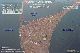
Point Hope Airport is a state-owned public-use airport located two miles (3 km) southwest of the central business district of Point Hope, a city in the North Slope Borough of the U.S. state of Alaska. Point Hope is located in the Lisburne Peninsula, on the Chukchi Sea coast.
Villa Gesell Airport is an airport serving Villa Gesell, an Atlantic coastal town in the Buenos Aires Province of Argentina.
Las Brujas Airport is a Cuban airport serving Cayo Santa María, a resort island in the municipality of Caibarién, Villa Clara Province.
South Andros Airport is an airport near Congo Town in South Andros, part of Andros Island in The Bahamas. It is also known as Congo Town Airport.
North Caicos Airport is an airport serving North Caicos, the second largest of the Turks and Caicos Islands.
South Caicos Airport is an airport serving South Caicos, the seventh largest of the Turks and Caicos Islands.
Lisala Airport is an airport serving the Congo River city of Lisala, the capital of the Mongala District in the Mongala Province of the Democratic Republic of the Congo. The runway is on the northwestern side of the city.
Joaquín de Agüero Airport, also known as Santa Lucía Airport, is an airport serving Playa Santa Lucía, a village of Nuevitas, in the Camagüey Province of Cuba.
