
Ponda (Portuguese: Pondá, is a city and a municipal council in the South Goa district of Goa, India. Located in the central area of Goa, Ponda lies 28 km southeast of Panaji, the capital of Goa and 17 km northeast of Margao, the district headquarters. Ponda is also known as "Antruz Mahal" because of its numerous famous temples and the area's rich cultural heritage.

Canacona is an administrative region in the district of South Goa, Goa state, India.
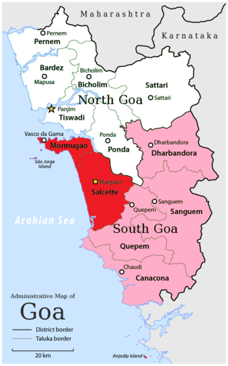
South Goa district is one of two districts that together constiitue the state of Goa, India, within the region known as the Konkan. It is bounded by North Goa district to the north, the Uttara Kannada district of Karnataka state to the east and south, while the Arabian Sea forms its western coast.

Benaulim (Bannalem) is a village in the state of Goa, India. Located in Salcete taluka of South Goa district, it neighbours Colva village to the north, Margao in the northeast and Varca village to the south. During Portuguese rule, it was one of the nine communidades in Salcete. Benaulim is the birthplace of St Joseph Vaz, who was a priest and missionary in Sri Lanka. Benaulim is home to several traditional carpenters, and has long been known as Goa's 'village of carpenters'. Contemporary Benaulim is a popular seaside resort, renowned for its beautiful rice fields, balmy weather and golden sand beaches. It also houses Goa's only Don Bosco Animation Centre. There are two big churches in Benaulim. The Holy Trinity Church in Mazilvaddo is a modern church built over the centuries-old chapel of the Loiola Pereira family. The St John the Baptist Church in Povacao area closer to Colva, is where St Joseph Vaz was baptised.
Canacona is a city and a municipal council in the district of South Goa, Goa state, India. Canacona taluka includes Patnem, Chaudi, Poinguinim, Loliem-Polem, Agonda, and Gaumdongre. Chaudi is the headquarters and the most developed town in this taluka. The famous Palolem Beach is located in Canacona.
Chicalim is a census town in Morumugão Sub-District, Goa, India. It is a suburb to the port city of Vasco da Gama.
Kilpennathur is a Panchayat Town in Tiruvanamalai district in the Indian state of Tamil Nadu. Kilpennathur is one of the taluks of Tiruvannamalai district and an assembly constituency of Tamil Nadu. The MLA of Kilpennathur assembly constituency is DMK party Mr. K. Pichandi. Vettavalam is the most populous town panchayat in this taluk. Kilpennathur is located a 12.25 degrees latitude and 79.224 degrees longitude. Nearest towns are Avalurpet, Vettavalam, Gingee and Tiruvannamalai, and Chennai is about 177 km away.
Londa is a census town in Belagavi district in the Indian state of Karnataka.The town is on border with state of Goa. The town is surrounded by lush evergreen forests known as Sahayadri or Western ghats of India. Londa is situated at the border of Belagavi district with Uttara Kannada district. Londa Junction railway station is located on the Belgaum - Goa and Goa to Dharwad railway route. Since it is a junction of two railway routes, Many tourists alight here to visit nearby forests of Kali Tiger Reserve. Londa is also connected by National Highway 748 connecting Goa to Belagavi via Anmod ghat. It is also connected to Uttara Kannada district headquarters Karwar by Karnataka state highway 34 (SH34)via Hankon, Kumbarwada, Anshi, Joida, Ganeshgudi and Ramnagar. Londa is connected by National highway 67 coming from Hubballi and Dharwar.
Quepem (Kepem) is a town with a municipal council in South Goa district in the Indian state of Goa. The town is the administrative headquarters of the Quepem taluka (sub-district).
Sanquelim or Sankhali is a town and municipal council in North Goa district in the Indian state of Goa.

Ujhani is an industry-based city and a municipal board in Badaun district in the Indian state of Uttar Pradesh.
Valpoi or Valpoy is a city and a municipal council in North Goa district in the Indian state of Goa. It is the headquarters of the Sattari Taluk. The Western Ghats are to the east of the town.
Santoshpur is a census town in Uluberia II CD Block of Uluberia subdivision in Howrah district in the Indian state of West Bengal. It is a part of Kolkata Urban Agglomeration.
Curchorem (Kudchade) is a City and municipal council in the South Goa district of Goa, India. Curchorem is a part of the Quepem taluka and is a twin town with Sanvordem, both located on either side of the Zuari River. The town is self-sufficient and has a number of hospitals, schools, a police station, banks, ATMs, a railway station, good road links, a market, places of worship, restaurants, a play ground, an electricity station and a theatre.
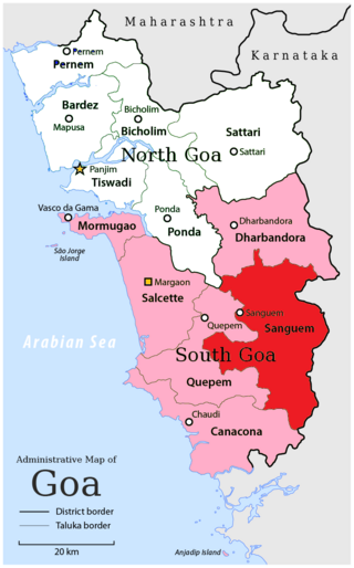
Sanguemtaluka is an administrative region of Goa state, India.

Quepem is a taluka of South Goa district in the state of Goa, India. It is an administrative region of Goa, India.
Pondataluka is a subdivision of the district of South Goa, in the Indian state of Goa. Its administrative headquarters is the township of Ponda.

Majorda is a village in Salcete, Goa. It is located in South Goa district, north-west of Margão. The village is famous for its beaches.
Mungurwadi is a town in Gadhinglaj Taluka of Kolhapur district in Maharashtra, India. In 2001 it had a population of 3,271, but as of 2011, it has a population of 12,199. It is a major market place and the tenth largest settlement in Gadhinglaj taluka. Mungurwadi is about 24 km from Gadhinglaj, 29 km from second-largest settlement Kadgaon and 12 km from National Highway 48 (NH48).

Goa Velha is a small town in Ilhas de Goa subdistrict, Goa state, India. It should not be confused with the World Heritage Site of the historical city of Old Goa. St Andrew's is its parish church. It is well known for its yearly 'Procession of the Saints'

