South Goa district

Last updated

South Goa district
South Goa Political Map.png
Location of South Goa district in Goa
Red: Velhas Conquistas (old Portuguese conquests)
Pink: Novas Conquistas (new Portuguese conquests)
Yellow: District Capital
CountryFlag of India.svg  India
State Flag placeholder.svg Goa
Headquarters Margao
Talukas
Government
   District collector Asvin Chandru A., I.A.S.
   Superintendent of Police Abhishek Dhania, IPS
   Lok Sabha constituencies South Goa
   Member of Parliament, Lok Sabha Francisco Sardinha (INC)
   Zilla Parishad, Chairperson Suvarna Tendulkar
Area
  Total1,966 km2 (759 sq mi)
  Rank 1st
Population
 (2011)
  Total640,537
  Rank 2nd
  Density330/km2 (840/sq mi)
   Urban
64.59%
Demographics
   Literacy 85.53%
  Sex ratio980
Time zone UTC+05:30 (IST)
PIN
4032xx ,4034xx, 4036xx, 4037xx,4038xx (South Goa) [1]
Telephone+91 0832
Vehicle registration GA-02
Major highways 1.National Highway 66,
2.National Highway 4A
Largest city Cuncolim (28.7 km2)
Largest city (by population) Mormugao
Climate Am (Köppen)
Website southgoa.nic.in

South Goa district is one of two districts that compose the state of Goa, India, within the region known as the Konkan. It is bounded by North Goa district to the north, the Uttara Kannada district of Karnataka state to the east and south, while the Arabian Sea forms its western coast.

Contents

History

The Portuguese established a colony in Goa in 1510 and expanded the colony to its present boundaries during the 17th and 18th centuries. Goa was annexed by India on 19 December 1961. Goa and two other former Portuguese enclaves became the union territory of Goa, Daman and Diu, and Goa was organised into a single district in 1965. On 30 May 1987 Goa attained statehood (while Daman and Diu became a separate union territory), and Goa was reorganised into two districts, North Goa and South Goa.

Administration

Asvin Chandru A, [2] an officer of the Indian Administrative Service, is the Collector and District Magistrate of South Goa. [3] There are deputy collectors and mamlatdars for each subdivision/taluka.

The headquarters of the district is Margao. [4]

There are 205 revenue villages in South Goa District under seven Talukas (subdistricts) headed each by the Mamlatdar. [5]

Divisions

Rural Salcete, South Goa Salcete scenery.jpg
Rural Salcete, South Goa

Margao is the administrative headquarters of the district. The 'Matanhy Saldanha Administrative Complex', the collectorate building, named after former minister and social activist Mr Mathany Saldanha, is located on the outskirts of the city, adjoining the intercity bus stand. [6]

The district is divided into five subdivisions Ponda, Mormugao-Vasco, Margao, Quepem, and Dharbandora; and seven talukas Ponda, Dharbandora, Sanguem, Mormugao (Vasco), Salcete (Margao), Quepem, and Canacona (Chaudi).

Ponda taluka was shifted from North Goa district to South Goa district in January 2015.

Politics

DistrictNo.ConstituencyNamePartyAllianceRemarks
South Goa 24 Mormugao Sankalp Amonkar Indian National Congress UPA Switched from INC to BJP on 14 September 2022 [7]
Bharatiya Janata Party NDA
25 Vasco da Gama Krishna Salkar Bharatiya Janata Party NDA
26 Dabolim Mauvin Godinho Bharatiya Janata Party NDA Cabinet Minister
27 Cortalim Antonio Vas Independent NDA
28 Nuvem Aleixo Sequeira Indian National Congress UPA Switched from INC to BJP on 14 September 2022 [7]
Bharatiya Janata Party NDA
29 Curtorim Aleixo Lourenco Independent NDA
30 Fatorda Vijai Sardesai Goa Forward Party I.N.D.I.A.
31 Margao Digambar Kamat Indian National Congress UPA Switched from INC to BJP on 14 September 2022 [7]
Bharatiya Janata Party NDA
32 Benaulim Venzy Viegas Aam Aadmi Party
33 Navelim Ulhas Tuenkar Bharatiya Janata Party NDA
34 Cuncolim Yuri Alemao Indian National Congress I.N.D.I.A.
35 Velim Cruz Silva Aam Aadmi Party
36 Quepem Altone D'Costa Indian National Congress I.N.D.I.A.
37 Curchorem Nilesh Cabral Bharatiya Janata Party NDA Cabinet Minister
38 Sanvordem Ganesh Gaonkar Bharatiya Janata Party NDA
39 Sanguem Subhash Phal Desai Bharatiya Janata Party NDA Cabinet Minister
40 Canacona Ramesh Tawadkar Bharatiya Janata Party NDA Speaker

Transport

Frequent buses are available between Margao and North Goa.

Demographics

Historical population
YearPop.±% p.a.
1900181,439    
1910180,429−0.06%
1920181,455+0.06%
1931191,667+0.50%
1940204,297+0.71%
1950216,574+0.59%
1960240,330+1.05%
1971336,808+3.12%
1981439,728+2.70%
1991504,989+1.39%
2001589,095+1.55%
2011640,537+0.84%
source: [8]

According to the 2011 census South Goa has a population of 6,40,537 [9] which is roughly equal to the nation of Montenegro [10] or the US state of Vermont. [11] This gives it a ranking of 515th in India (out of a total of 640). The district has a population density of 326 inhabitants per square kilometre (840/sq mi). Its population growth rate over the decade 2001–2011 was 8.63%. South Goa has a sex ratio of 980 females for every 1000 males, and a literacy rate of 85.53%. [9] The Scheduled Castes and Scheduled Tribes make up 1.22% and 14.47% of the population of the district. [12]

Religion

Religion in South Goa district [13]
ReligionPercent
Hinduism
53.34%
Christianity
36.21%
Islam
9.93%
Others
0.5%

Hinduism (53%) is followed by the majority of population of South Goa. Christians (36%) form significant minority. [13]

Language

Languages of South Goa district (2011) [14]

   Konkani (66.44%)
   Hindi (12.38%)
   Marathi (6.45%)
   Kannada (3.62%)
   Urdu (3.39%)
   Malayalam (1.00%)
  Others (6.72%)

At the time of the 2011 Census of India, 66.44% of the population in the district spoke Konkani, 12.38% Hindi, 6.45% Marathi, 5.98% Kannada, 3.39% Urdu, 1.00% Malayalam, 0.86% Telugu, 0.55% Bengali, 0.49% Tamil, 0.49% Gujarati, 0.44% Odia and 0.42% English as their first language. [15]

Education

There are many educational institutions in South Goa. The prominent colleges include:

Related Research Articles

<span class="mw-page-title-main">Ponda, Goa</span> City in Goa, India

Ponda (Portuguese: Pondá, is a city and a municipal council in the South Goa district of Goa, India. Located in the central area of Goa, Ponda lies 28 km southeast of Panaji, the capital of Goa and 17 km northeast of Margao, the district headquarters. Ponda is also known as "Antruz Mahal" because of the presence of numerous famous temples and rich cultural heritage.

<span class="mw-page-title-main">Margao</span> City in Goa, India

Margao is the commercial capital of the Indian state of Goa. It stands on banks of the Sal river and is the administrative headquarters of Salcete sub-district and South Goa district. It is Goa's second largest city by population after Vasco.

<span class="mw-page-title-main">Salcete</span> Taluka in South Goa, India

Salcete is a subdivision of the district of South Goa, in the state of Goa, situated by the west coast of India. The Sal River and its backwaters dominate the landscape of Salcete. Historically, the sixty-six settlements south of the Zuari River formed the original Salcette territory. Salcete forms a part of the bigger Konkan region that stretches along the western shoreline of peninsular India.

<span class="mw-page-title-main">North Goa district</span> District in Goa, India

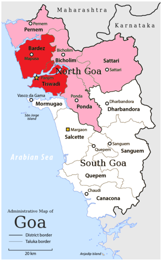
North Goa district is one of the two districts that constitutes the state of Goa, India. The district has an area of 1,736 square kilometres, and is bounded by Kolhapur and Sindhudurg districts of Maharashtra state to the north and by Belgavi district of Karnataka to the east, by South Goa district to the south, and by the Arabian Sea to the west.

<span class="mw-page-title-main">Mormugao</span> City in Goa, India

Mormugao is a seaport city situated in the eponymous Mormugao taluka (municipality) of the South district, in the Goa state, India. It has a deep natural harbour and remains Goa's chief port.

<span class="mw-page-title-main">Goa University</span> Public university in Goa, India

Goa University is a public state research university headquartered in the city of Panaji, in the Indian state of Goa. In addition to Panaji, it has a campus in Margao, Mapusa, Ponda, Old Goa and Vasco da Gama.

This is a timeline of Goan history. It overlaps with the histories of other regions in South Asia, the Indian subcontinent, and colonial powers that influenced the region, including Portugal.

<span class="mw-page-title-main">Cortalim</span> Village in Goa, India

Cortalim is a village in Morumugão, Goa, India. Its native Goan population is entirely Catholic and their main occupations include fishing and agriculture. Located on the banks of the Zuari River, it was previously known as Kushasthale.

Gogol is a town and suburb of the city of Margao in South Goa district in the state of Goa, India. Gogol is a well connected suburb with good infrastructure such as schools, colleges, post office, banks, public transport, shopping areas close to Margao city.

Raia is a quaint village in the Salcete taluka of South Goa district, Goa state, India. It is located 4 km (2.5 mi) east from the district headquarters of Margao and 35 km (22 mi) from the state capital Panjim.

Khandepar is a census town in Ponda taluka, North Goa district in the state of Goa, India.

<span class="mw-page-title-main">Ponda taluka</span> Taluka in Goa, India

Pondataluka is a subdivision of the district of South Goa, Goa state, India. Its administrative headquarters is the township of Ponda.

José Matanhy de Saldanha was an Indian social activist, journalist, former Member of the Goa Legislative Assembly and school teacher, who campaigned for Goan identity, values, and culture. He also served as a Cabinet Minister in the Government of Goa with portfolios of Tourism as well as Science and Environment.

<span class="mw-page-title-main">Goa</span> State in Western India

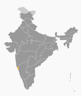
Goa is a state on the southwestern coast of India within the Konkan region, geographically separated from the Deccan highlands by the Western Ghats. It is bound by the Indian states of Maharashtra to the north, and Karnataka to the east and south, with the Arabian Sea in the west. It is India's smallest state by area and fourth-smallest by population. Goa has the highest GDP per capita among all Indian states, two and a half times as high as the GDP per capita of the country as a whole. The Eleventh Finance Commission of India named Goa the best-placed state because of its infrastructure, and India's National Commission on Population rated it as having the best quality of life in India. It is the second-highest ranking among Indian states in the human development index.

<span class="mw-page-title-main">Outline of Goa</span> Overview of and topical guide to Goa

The following outline is provided as an overview of and topical guide to Goa:

<span class="mw-page-title-main">Urminda Mascarenhas</span> Indian politician, educator and businessperson (1926–2010)

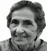
Urminda Mascarenhas e Lima Leitao was an Indian politician, educator and businessperson from Goa. She was a former member of the Goa, Daman and Diu Legislative Assembly, representing the Mormugao Assembly constituency from 1963 to 1967.

References

  1. South Goa
  2. "Witness in the Corridors". Archived from the original on 19 March 2023.
  3. "Who's Who | South Goa District | India". southgoa.nic.in. Archived from the original on 25 March 2021. Retrieved 25 March 2021.
  4. "District Profile - South Goa District Website, Goa, India". Archived from the original on 28 May 2014. Retrieved 17 April 2014.
  5. "Tehsil | South Goa District | India" . Retrieved 9 April 2020.
  6. TNN (31 May 2013). "South Goa collectorate named after Matanhy". The Times of India . Margao: The Times Group . Retrieved 10 December 2019.
  7. 1 2 3 "8 Goa Congress MLAs defect to BJP". The Indian Express. 14 September 2022. Retrieved 14 September 2022.
  8. "Census of India Website : Office of the Registrar General & Census Commissioner, India". www.censusindia.gov.in.
  9. 1 2 "District Census 2011". Census2011.co.in. 2011. Retrieved 30 September 2011.
  10. US Directorate of Intelligence. "Country Comparison:Population". Archived from the original on 13 June 2007. Retrieved 1 October 2011. Montenegro 661,807 July 2011 est.
  11. "2010 Resident Population Data". United States Census Bureau. Retrieved 30 September 2011. Vermont 625,741
  12. "South Goa District Population, Goa, List of Talukas in South Goa". Censusindia2011.com. Retrieved 22 April 2023.
  13. 1 2 "C-1 Population By Religious Community". census.gov.in. Retrieved 15 September 2020.
  14. "C-16 Population By Mother Tongue - Goa". censusindia.gov.in. Retrieved 4 October 2019.
  15. "C-16 Population By Mother Tongue - Goa". censusindia.gov.in. Retrieved 4 October 2019.
  16. "Parvatibai Chowgule College - About SPCC". Archived from the original on 25 April 2014. Retrieved 25 April 2014.
  17. "G. R. Kare College of Law - About Us". Archived from the original on 28 May 2014. Retrieved 9 May 2014.
  18. "Padre Conceição College Of Engineering". www.pccegoa.org.
  19. "M.E.S. College of Arts & Commerce". www.mescollege.org.

15°16′21″N73°57′30″E / 15.2724°N 73.9583°E / 15.2724; 73.9583