Sankt Oswald bei Plankenwarth | |
|---|---|
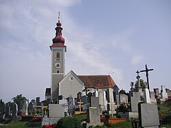 Sankt Oswald parish church and cemetery | |
 Coat of arms | |
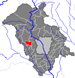 Location within Graz-Umgebung district | |
 Sankt Oswald bei Plankenwarth Location within Austria | |
| Coordinates: 47°04′47″N15°16′47″E / 47.07972°N 15.27972°E | |
| Country | Austria |
| State | Styria |
| District | Graz-Umgebung |
| Government | |
| • Mayor | Andreas Staude (SPÖ) |
| Area | |
• Total | 11.75 km2 (4.54 sq mi) |
| Elevation | 557 m (1,827 ft) |
| Population (2018-01-01) [2] | |
• Total | 1,244 |
| • Density | 110/km2 (270/sq mi) |
| Time zone | UTC+1 (CET) |
| • Summer (DST) | UTC+2 (CEST) |
| Postal code | 8113 |
| Area code | 03123 |
| Vehicle registration | GU |
| Website | www.sanktoswald.net |
Sankt Oswald bei Plankenwarth is a municipality in the district of Graz-Umgebung in the Austrian state of Styria. It has a population of around 1,300 residents. Key landmarks of this region are the Pfarrkirche St. Oswald, a Roman Catholic parish church perched on a hill, and the Schloss Plankenwarth. [3]