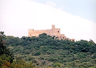
La Jonquera is a municipality in the comarca of l'Alt Empordà, in Catalonia, Spain. It is situated next to the border with Northern Catalonia, nowadays France, opposite the municipality of Le Perthus.

Ferrocarrils de la Generalitat de Catalunya, or FGC, is a railway company which operates several unconnected lines in Catalonia, Spain.

Sant Feliu de Llobregat is an industrial city and municipality in Catalonia, Spain, in the province of Barcelona. It is the capital of the comarca of Baix Llobregat, and the see of a bishopric since June 2005.

Sant Andreu de Llavaneres is a municipality located 36 km north of Barcelona (Catalonia) (Spain), along the Mediterranean coast, between Mataró and Sant Vicenç de Montalt. It belongs to the Maresme comarca and the Barcelona province. The short name is simply Llavaneres.

The Volta a Catalunya is a road bicycle race held annually in Catalonia, Spain.
Santa Maragarida de Montbui is a municipality in the comarca of the Anoia in Catalonia, Spain. It is situated in the Òdena Basin, immediately to the west of Igualada of which it effectively forms a suburb. The ajuntament is in Sant Maure. Other neighbourhoods in Montbui are the Old Town, el Saió-Coll del Guix and La Mallola.

Calonge is a municipality in the comarca of the Baix Empordà in Catalonia, Spain, on the coastline of the Costa Brava.

La Guingueta d'Àneu is a municipality in the comarca of the Pallars Sobirà in Catalonia, Spain. It is situated in the valley of the Noguera Pallaresa river below the reservoir of La Torrassa. It is linked to Sort by the C-147 road.

Saldes is a municipality in the comarca of the Berguedà in Catalonia, Spain. It is situated at the foot of the Pedraforca mountain in the north of the comarca. Deposits of lignite are extracted commercially. The village is linked to Guardiola de Berguedà by a local road. The monastery Sant Sebastià del Sull is located in Saldes.
Sant Iscle de Vallalta is a municipality in the comarca of the Maresme in Catalonia, Spain. It is situated inland from the coast, in the valley of the Sant Pol river below the Montnegre range. A local road links the town with Arenys de Munt, Sant Cebria De Vallata and Sant Pol de Mar.

Borredà is a municipality in the comarca of the Berguedà in Catalonia, Spain. It is situated in the upper valley of the Margençol river in the east of the comarca. There are several notable houses from the 17th and 18th centuries. The Romanesque church of Sant Sadurní de Rotgers, a protected historico-artistic monument, can be reached by a mountain track. The village is served by the C-149 road between Berga and Sant Quirze de Besora. The municipality surrounds an exclave of Les Llosses.

Sant Jaume de Frontanyà is a municipality in the comarca of the Berguedà in Catalonia, Spain. It is situated in the Pyrenees below the peak of Pedró de Tubau (1543 m). The village was the smallest municipality in Catalonia in terms of population but in 2018 lost the title to Gisclareny after the village grew. The monumental Romanesque church of Sant Jaume is a protected historic-artistic monument from the 11th century. The village is served by a local road to Borredà and it is well known for its peace and tranquility.

The Catalan Transversal Range is a system of minor mountain ranges at the eastern end of the Pre-Pyrenees, between the Osona and Garrotxa comarques. The existence of the Catalan Transversal Range has made communications in the northern areas of Catalonia difficult in the past, especially between Northeastern Catalonia and Western Catalonia, a problem that has been partly solved with the development of the Eix Transversal.
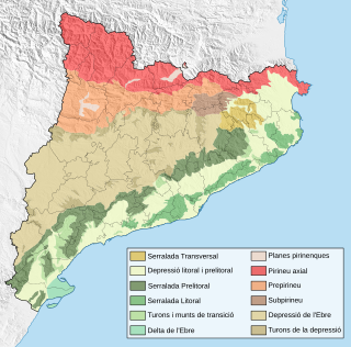
The Sub-Pyrenees are a mountainous region in Catalonia, Spain, forming a section of the southern foothills of the Pyrenees. They are located at the eastern end of the Pre-Pyrenees, west of the Catalan Transversal Range, between the lower Ripollès and an area of the high Garrotxa.

Meranges is a village in the comarca of Cerdanya, province of Girona, Catalonia, north-eastern Spain.

Muntanya de Santa Bàrbara is a mountain that is part of the northwestern foothills of the Ports de Tortosa-Beseit, Catalonia, Spain. It has an elevation of 751.3 metres (2,465 ft) above sea level.

Sant Llorenç del Munt is a largely rocky mountain massif in central Catalonia, Spain. The highest summit, where the Monestir de Sant Llorenç del Munt is located, has an elevation of 1,104.2 metres (3,623 ft) above sea level and is known as La Mola. Montcau 1,056.8 metres (3,467 ft) is another important peak of the massif. On the massif, there is a protected area under the name Parc Natural de Sant Llorenç del Munt i l'Obac.
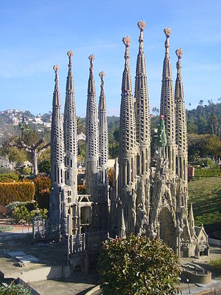
Catalunya en Miniatura is a miniature park inaugurated in 1983 in Torrelles de Llobregat, 17 km (11 mi) from Barcelona. The park is 60,000 m2 (650,000 sq ft), 35,000 m2 (380,000 sq ft) of them devoted to the scale models, it is one of the largest miniature parks in the world, and the largest of the 14 miniature building exhibitions present in Europe. It displays 147 models of palaces, churches, bridges and other buildings from Catalonia and Mallorca and it includes all the major works by the renowned architect Antoni Gaudí.
Alforja is a municipality in the comarca of Baix Camp, in the province of Tarragona, Catalonia, Spain.
Vilanova de Prades is a municipality in the comarca of Conca de Barberà, in the province of Tarragona, Catalonia, Spain. It is a popular holiday resort located at high altitude atop the Serra de la Llena, close to the area where this mountain range meets the Prades Mountains.

