Santa Anita Creek

Last updated
Santa Anita Creek
Big Santa Anita Creek,Santa Anita Wash [1]
River
First water (327235848).jpg
The creek near the First Water trail junction
Country United States
State California
Region Los Angeles County
Part of Rio Hondo
Tributaries
 - left North Fork Santa Anita Creek,East Fork Santa Anita Creek
 - right Winter Creek
Cities Sierra Madre, Arcadia, Monrovia, Azusa, Irwindale
Landmark Sturtevant Falls
Source Eastern flank of Mount Wilson
 - location Angeles National Forest, San Gabriel Mountains
 - elevation 4,600 ft (1,402 m)
Mouth Rio Hondo
 - location Irwindale, San Gabriel Valley
 - elevation 320 ft (98 m)
 - coordinates 34°06′12″N118°00′56″W / 34.10333°N 118.01556°W / 34.10333; -118.01556 Coordinates: 34°06′12″N118°00′56″W / 34.10333°N 118.01556°W / 34.10333; -118.01556
Length 10.4 mi (17 km), North-south
Basin 15 sq mi (39 km2)
Discharge
 - average 9 cu ft/s (0 m3/s)
 - max 7,000 cu ft/s (198 m3/s)
 - min 0 cu ft/s (0 m3/s)

Santa Anita Creek (Santa Anita Wash on federal maps [1] ) is a 10.4-mile (16.7 km) long stream in Los Angeles County, California. It flows southwards from its headwaters in the south ridge of the San Gabriel Mountains, to form the beginnings of the Rio Hondo near Irwindale.

California State of the United States of America

California is a state in the Pacific Region of the United States. With 39.6 million residents, California is the most populous U.S. state and the third-largest by area. The state capital is Sacramento. The Greater Los Angeles Area and the San Francisco Bay Area are the nation's second- and fifth-most populous urban regions, with 18.7 million and 8.8 million residents respectively. Los Angeles is California's most populous city, and the country's second-most populous, after New York City. California also has the nation's most populous county, Los Angeles County, and its largest county by area, San Bernardino County. The City and County of San Francisco is both the country's second-most densely populated major city after New York City and the fifth-most densely populated county, behind only four of the five New York City boroughs.

San Gabriel Mountains mountain range in Los Angeles and San Bernardino Counties, California

The San Gabriel Mountains are a mountain range located in northern Los Angeles County and western San Bernardino County, California, United States. The mountain range is part of the Transverse Ranges and lies between the Los Angeles Basin and the Mojave Desert, with Interstate 5 to the west and Interstate 15 to the east. This range lies in, and is surrounded by, the Angeles National Forest, with the San Andreas Fault as the northern border of the range.

Rio Hondo (California) river in Los Angeles County, California, USA

The Rio Hondo is a tributary of the Los Angeles River in Los Angeles County, California, approximately 16.4 miles (26.4 km) long. As a named river, it begins in Irwindale and flows southwest to its confluence in South Gate, passing through several cities. Above Irwindale its main stem is known as Santa Anita Creek, which extends another 10 miles (16 km) northwards into the San Gabriel Mountains where the source, or headwaters, of the river are found.

Course

The creek begins on the east slope of Mount Wilson, inside the Angeles National Forest. It flows in a curve southeast through Santa Anita Canyon, then drops over the 60-foot (18 m) Sturtevant Falls. The North Fork comes in from the left about a quarter-mile above the falls, and the East Fork also from the left about a quarter-mile downstream. The creek then flows south through a group of about 80 historic cabins on the canyon floor, before receiving Winter Creek from the right near Chantry Flat. Shortly downstream of there, it drops over Hermit Falls and flows into Santa Anita Reservoir, which is impounded by the 225-foot (69 m) Santa Anita Dam.

Mount Wilson (California) mountain in California, USA

Mount Wilson is a peak in the San Gabriel Mountains, located within the San Gabriel Mountains National Monument and Angeles National Forest in Los Angeles County, California. With only minor topographical prominence the peak is not naturally noticeable from a distance, although it is easily identifiable due to the large number of antennas near its summit. It is a subsidiary peak of nearby San Gabriel Peak.

Angeles National Forest

The Angeles National Forest (ANF) of the U.S. Forest Service is located in the San Gabriel Mountains and Sierra Pelona Mountains, primarily within Los Angeles County in southern California. The ANF manages a majority of the San Gabriel Mountains National Monument.

Santa Anita Canyon is a canyon in the San Gabriel Mountains, within the Angeles National Forest in Los Angeles County, California.

Leaving the foothills the creek continues southwards through Sierra Madre, Monrovia and Arcadia as the Santa Anita Wash, flowing in a concrete channel. It turns southeast towards Azusa, then south again at Irwindale, where it empties into a small flood control basin.

Sierra Madre, California City in California

Sierra Madre is a city in Los Angeles County, California whose population was 10,917 at the 2010 U.S. Census, up from 10,580 at the time of the 2000 U.S. Census. The city is in the foothills of the San Gabriel Valley below the southern edge of the Angeles National Forest. Pasadena and Altadena are to its west, with Arcadia to its south and east. Sierra Madre is known as "Wisteria City", and its city seal is decorated with a drawing of the now widely known 500-foot (150 m) vine. It is also called the "Village of the Foothills" and was an All-America City in 2007.

Monrovia, California City in California

Monrovia is a city located in the foothills of the San Gabriel Mountains in the San Gabriel Valley of Los Angeles County, California, United States. The population was 36,590 at the 2010 census, down from 36,929 in 2000. Monrovia has been used for filming TV shows, movies and commercials.

Arcadia, California City in California, United States

Arcadia is a city in Los Angeles County, California, United States located about 13 miles (21 km) northeast of downtown Los Angeles in the San Gabriel Valley and at the base of the San Gabriel Mountains. It is the site of the Santa Anita Park racetrack and home to the Los Angeles County Arboretum and Botanic Garden. The city had a population of 56,364 at the 2010 census, up from 53,248 at the 2000 census. The city is named after Arcadia, Greece.

The water continues out of the basin as the Rio Hondo, which flows southwards to junctions with the San Gabriel River and the Los Angeles River. [2]

San Gabriel River (California) river in Los Angeles County, California, United States

The San Gabriel River is a mostly urban waterway flowing 58 miles (93 km) southward through Los Angeles and Orange Counties, California in the United States. It is the central of three major rivers draining the Greater Los Angeles Area, the others being the Los Angeles River and Santa Ana River. The river's watershed stretches from the rugged San Gabriel Mountains to the heavily developed San Gabriel Valley and a significant part of the Los Angeles coastal plain, emptying into the Pacific Ocean between the cities of Long Beach and Seal Beach.

Los Angeles River river in California that was the primary source of fresh water for the city but suffers pollution from agricultural and urban runoff.

The Los Angeles River starts in the Simi Hills and Santa Susana Mountains and flows through Los Angeles County, California, from Canoga Park in the western end of the San Fernando Valley, nearly 51 miles (82 km) southeast to its mouth in Long Beach. Several tributaries join the once free-flowing and frequently flooding river, forming alluvial flood plains along its banks. It now flows through a concrete channel on a fixed course, which was built after a series of devastating floods in the early 20th century.

Related Research Articles

Little Colorado River river in the United States of America

The Little Colorado River is a tributary of the Colorado River in the U.S. state of Arizona, providing the principal drainage from the Painted Desert region. Together with its major tributary, the Puerco River, it drains an area of about 26,500 square miles (69,000 km2) in eastern Arizona and western New Mexico. Although it stretches almost 340 miles (550 km), only the headwaters and the lowermost reaches flow year-round. Between St. Johns and Cameron, most of the river is a wide, braided wash, only containing water after heavy snowmelt or flash flooding.

Skykomish River river in Washington

The Skykomish River is a Washington river which drains the west side of the Cascade Mountains in the southeast section of Snohomish County and the northeast corner of King County. The river starts with the confluence of the North Fork Skykomish River and South Fork Skykomish River approximately one mile west of Index, then flowing northwesterly towards Puget Sound. It is joined by the Sultan River and the Wallace River at Sultan. It then meets the Snoqualmie River to form the Snohomish River at Monroe. The Snohomish River continues along the river valley eventually dumping into Port Gardner Bay on Possession Sound.

Tule River river in the United States of America

The Tule River, also called Rio de San Pedro or Rio San Pedro, is a 71.4-mile (114.9 km) river in Tulare County in the U.S. state of California. The river originates in the Sierra Nevada east of Porterville and consists of three forks, North, Middle and South. The North Fork and Middle Fork meet above Springville. The South Fork meets the others at Lake Success. Downstream of Success Dam, the river flows west through Porterville. The river used to empty into Tulare Lake, but its waters have been diverted for irrigation. However, the river does reach Tulare Lake during floods. Tulare Lake is the terminal sink of an endorheic basin that historically also received the Kaweah and Kern Rivers as well as southern distributaries of the Kings.

Whittier Narrows

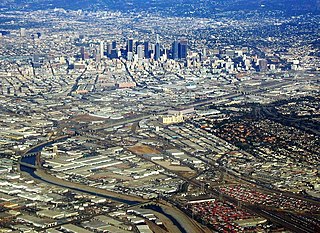
The Whittier Narrows is a water gap between the Puente Hills to the east and the Montebello Hills to the west. The gap is located at the southern boundary of the San Gabriel Valley, through which the Rio Hondo and the San Gabriel River flow through to enter the Los Angeles Basin. The gap is also traversed by both Interstate 605 and California State Route 19.

San Jacinto River (California)

The San Jacinto River is a 42-mile-long (68 km) river in Riverside County, California. The river's headwaters are in San Bernardino National Forest, but the lower portion of the 765-square-mile (1,980 km2) watershed is urban and agricultural land. As a partially endorheic watershed that is contiguous with other Great Basin watersheds, the western side of the San Jacinto Basin is a portion of the Great Basin Divide.

Lytle Creek (California) river in the United States of America

Lytle Creek, California, is an approximately 18-mile-long (29 km) stream in southwestern San Bernardino County near the city of San Bernardino. It is a tributary of Warm Creek, a tributary of the Santa Ana River. The Mormon settlers of San Bernardino named the stream "Lytle Creek" after their leader, Captain Andrew Lytle.

Rio Chama

The Rio Chama, a major tributary river of the Rio Grande, is located in the U.S. states of Colorado and New Mexico. The river is about 130 miles (210 km) long altogether. From its source to El Vado Dam its length is about 50 miles (80 km), from El Vado Dam to Abiquiu Dam is about 51 miles (82 km), and from Abiquiu Dam to its confluence with the Rio Grande is about 34 miles (55 km).

Eaton Canyon canyon in the San Gabriel Mountains in Los Angeles County, California

Eaton Canyon is a major canyon beginning at the Eaton Saddle near Mount Markham and San Gabriel Peak in the San Gabriel Mountains in the Angeles National Forest, United States. Its drainage flows into the Rio Hondo river and then into the Los Angeles River. It is named after Judge Benjamin S. Eaton, who lived in the Fair Oaks Ranch House in 1865 not far from Eaton Creek.

Sierra Madre Dam

The Sierra Madre Dam is a dam on Little Santa Anita Creek, at the mouth of Little Santa Anita Canyon, in Los Angeles County, California. It is in the San Gabriel Mountains, south of the Angeles National Forest, on the northern border of Sierra Madre.

Piedra River (Colorado) river in the United States of America

The Piedra River is a river in the U.S. state of Colorado. It drains parts of Archuleta, Hinsdale, and Mineral counties along a mainstem length of about 40 miles (64 km). The river flows through a series of isolated box canyons, emptying into the San Juan River at Navajo Lake. Its name stems from the Spanish word, piedra, meaning rock.

Coyote Creek (San Gabriel River tributary) stream in Southern California, tributary of the San Gabriel River

Coyote Creek is a principal tributary of the San Gabriel River in northwest Orange County, southeast Los Angeles County, and southwest Riverside County, California. It drains a land area of roughly 41.3 square miles (107 km2) covering five major cities, including Brea, Buena Park, Fullerton, La Habra, and La Palma. Some major tributaries of the creek in the highly urbanized watershed include Brea Creek, Fullerton Creek, and Carbon Creek. The mostly flat creek basin is separated by a series of low mountains, and is bounded by several small mountain ranges, including the Chino Hills, Puente Hills and West Coyote Hills.

Jemez River river in the United States of America

The Jemez River is a tributary of the Rio Grande in the U.S. state of New Mexico. The river is formed by the confluence of the East Fork Jemez River and San Antonio Creek, which drain a number of tributaries in the area of the Jemez Mountains and Santa Fe National Forest. The Jemez River is about 50 miles (80 km) long, or about 80 miles (130 km) long if its longest headwater tributary, San Antonio Creek, is included. The East Fork Jemez River is about 22 miles (35 km) long. Both San Antonio Creek and the East Fork Jemez River flow through intricate meanders along their courses. The East Fork Jemez is a National Wild and Scenic River.

South Fork Coquille River river in the United States of America

The South Fork Coquille River is the longest tributary of the Coquille River in coastal Oregon in the United States. From its headwaters in the Southern Oregon Coast Range, the river flows northwest to join the North Fork Coquille River at Myrtle Point, forming the main stem Coquille. The South Fork is about 63 miles (101 km) long, and its watershed drains roughly 288 square miles (750 km2) of rural Coos County.

Chino Creek river in the United States of America

Chino Creek is a major stream of the Pomona Valley, in the western Inland Empire region of Southern California. It is a tributary of the Santa Ana River.

Middle Fork Kings River river in the United States of America

The Middle Fork Kings River is a 37.2-mile (59.9 km) tributary of the Kings River in Kings Canyon National Park, California, in the southern Sierra Nevada. Draining 318 square miles (820 km2) – almost all of it wilderness – the Middle Fork is one of the largest wholly undeveloped watersheds in the state, with no dams or paved roads within its basin. The entire length of the Middle Fork is designated a National Wild and Scenic River.

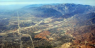
San Antonio Creek is a major stream in Los Angeles County and San Bernardino County, California, draining southwards from Mount San Antonio in the San Gabriel Mountains into Chino Creek, a tributary of the Santa Ana River. Upon leaving San Antonio Canyon and entering the broad alluvial plain of the Pomona Valley, it is known as the San Antonio Wash or the San Antonio Creek Channel, the former referring to the creek's seasonal dry nature below the mouth of San Antonio Canyon.

Little Rock Creek (Los Angeles County, California)

Little Rock Creek is a 16.7-mile (26.9 km) northwestward-flowing stream in the San Gabriel Mountains and Mojave Desert, within northern Los Angeles County, California.

References