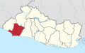
Santa Rosa de Copán is a municipality in Honduras. The city of Santa Rosa de Copán is the municipal seat and the departmental capital of the Honduran department of Copán. It is located approximately 1,150 metres (3,773 ft) above mean sea level.
This is a list of the extreme points of the United Kingdom: the points that are farther north, south, east or west than any other location. Traditionally the extent of the island of Great Britain has stretched "from Land's End to John o' Groats".

Cornsay is a hamlet and civil parish in County Durham, England. The population of the Civil Parish taken at the 2011 census was 1,128. It is 6 miles (9.7 km) southeast of Consett and 7 miles (11 km) southwest of Durham. It consists of nineteen dwellings, including four farms & is the home of Greenacres nudist club. All formerly belonged to Ushaw College for the training of Catholic priests, hence the organised nomenclature. East and West Farms are now in private hands as homes but the other two are still active, South Farm run by the Suddes family and North Farm by the Tweddle family.
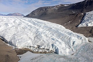
The Taylor Glacier is a glacier in Antarctica about 35 nautical miles long, flowing from the plateau of Victoria Land into the western end of Taylor Valley, north of the Kukri Hills. It flows to the south of the Asgard Range. The middle part of the glacier is bounded on the north by the Inland Forts and on the south by Beacon Valley.
Meámbar is a municipality in the Honduran department of Comayagua.

Ambalema is a municipality in the Tolima department of Colombia. The population of Ambalema was 7,277 as of the 1993 census.
Pedro Bank is a large bank of sand and coral, partially covered with seagrass, about 80 km south and south-west of Jamaica, rising steeply from a seabed of 800 m depth.

Rakovec nad Ondavou is a village and municipality in Michalovce District in the Kosice Region of eastern Slovakia.

Geszteréd is a village in Szabolcs-Szatmár-Bereg county, in the Northern Great Plain region of eastern Hungary. It covers an area of 33.52 km2 (13 sq mi) and has a population of 1718 people (2015).
La Pesca is a small town in the Mexican state of Tamaulipas. It is located on the Gulf of Mexico, at the mouth of the Río Soto La Marina, between the Laguna Madre to the north and the Laguna Morales to the south. It stands due east of state capital Ciudad Victoria, in the municipality of Soto la Marina.

Sungurlare is a town in southeastern Bulgaria, part of Burgas Province. It is the administrative centre of Sungurlare municipality, which lies in the northwestern part of Burgas Province.
This is a list of the extreme points and extreme elevations in Scotland.
Rəmə is a village in the municipality of Samanlıq in the Gadabay Rayon of Azerbaijan.
Rocca Islands is a group of small islands and rocks 3 nautical miles (6 km) east of Avian Island, off the south end of Adelaide Island. Discovered in 1909 by the French Antarctic Expedition and named by Charcot for Monsieur Rocca, an acquaintance in Punta Arenas. Remapped by the British Royal Navy Hydrographic Survey Unit in 1963.
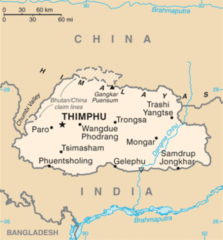
This is a list of the extreme points of Bhutan.

The Moscos Islands are an island chain in the Andaman Sea off the northern coast of the Tanintharyi Region of southern Burma.
Oulad Chrif is a commune in the Taza Province of the Taza-Al Hoceima-Taounate administrative region of Morocco. At the time of the 2004 census, the commune had a total population of 10439 people living in 1403 households.

German submarine U-1279 was a Type VIIC/41 U-boat of Nazi Germany's Kriegsmarine during World War II.
Harrisburg Township is a township in Van Buren County, Iowa, United States.
This page is based on this
Wikipedia article Text is available under the
CC BY-SA 4.0 license; additional terms may apply.
Images, videos and audio are available under their respective licenses.