
Santa Maria in Gruptis is a former abbey located in the comune of Vitulano, in the Campania region of Southern Italy. Founded in the 10th century and used by several monastic orders, it was deconsecrated in 1705, and is currently in ruins.
Contents

Santa Maria in Gruptis is a former abbey located in the comune of Vitulano, in the Campania region of Southern Italy. Founded in the 10th century and used by several monastic orders, it was deconsecrated in 1705, and is currently in ruins.
The name "in gruptis" refers to the karst caves in the area, which were used to gather and distribute water to the abbey. [1] [2] The oldest recorded name was Santa Maria di Monte Drago, in reference to the mountain where the abbey is located. [1] [3] The two names were used in the 12th century with inconsistent spellings, such as "Santa Maria di Monte Drocho", "Santa Maria in Cripta", "Santa Maria de la Grocta". [4] In a 1545 decree by the then abbot Blasio Sellaroli the abbey was named Santa Maria dello Vallo di Vitulano ("Saint Mary of the Valley of Vitulano"). [5]
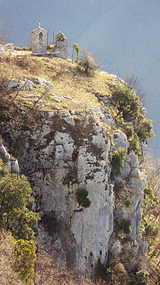
The former abbey is located at an elevation of 607 metres above sea level, [6] on Mount Drago, one of the mountains composing the Taburno Camposauro massif, in the province of Benevento. [4] It belongs to the comune of Foglianise, although geographically it is part of the Vitulano municipality. [7] [8] It is located on the side of a gorge known as "funno", in a steep and strategic position with a view over the valley. [2] [9] [3] It can be reached only by foot, with hiking trails. [6]

The abbey was founded between 940 and 944 by one of the Longobard princes of Benevento, either Atenulf II or Atenulf III. [1] [10] [7] The first recorded documents related to the abbey date back to 1164. It was inhabited by a succession of monastic orders: at first the Benedictines monks, for whose use it was initially intended, then the Celestines and then the Humiliati. [2] [4] The abbey owned several fiefs. [3] [7] In 1303 the Anjous attempted to incorporate the abbey into another abbey, that of Santa Maria in Mazzocca, near Foiano di Val Fortore. A popular revolt from the inhabitants of the area halted the plan.
In 1660, the abbey was given to the Camaldolese monks, [2] but it was abandoned after the 1688 Sannio earthquake. It was deconsecrated by Cardinal Orsini (later Pope Benedict XIII) in 1705 because of its state of neglect and the continued attacks by brigands, who later used it as a refuge because of its strategic position. [7] [4] The parchments produced in the abbey were bought at the beginning of the 19th century by antiquarians, and were donated by their heirs to the Società Napoletana di Storia Patria (it), where they are still kept. [11]
Today large portions of ruins of the abbey remain. Still visible are the tower, the entrance portal, and part of the encircling walls, which were built at a later date. Of the ancient church remains the apse. [9]

The Province of Caserta is a province in the Campania region of southern Italy. Its capital is the city of Caserta, situated about 36 kilometres (22 mi) by road north of Naples. The province has an area of 2,651.35 square kilometres (1,023.69 sq mi), and a total population of 924,414 as of 2016. The Palace of Caserta is located near to the city, a former royal residence which was constructed for the Bourbon kings of Naples. It was the largest palace and one of the largest buildings erected in Europe during the 18th century. In 1997, the palace was designated a UNESCO World Heritage Site.

Montesarchio is a comune in the Province of Benevento, Campania, southern Italy. It is located 18 kilometres south-west of Benevento in the Valle Caudina at the foot of Monte Taburno. The commune was granted the official status of City (Città) by a presidential decree of 31 July 1977.
Mignano Monte Lungo is a comune (municipality) in the Province of Caserta in the Italian region Campania, located about 70 kilometres (43 mi) northwest of Naples and about 45 kilometres (28 mi) northwest of Caserta.
Airola is a comune (municipality) in the Province of Benevento in the Italian region Campania, located about 35 km northeast of Naples and about 20 km southwest of Benevento in the Valle Caudina, facing the Monte Taburno. Nearby is the confluence of the Tesa and Faenza streams into the Isclero River. Airola's territory is also crossed by the Acquedotto Carolino, carrying waters to the Caserta Palace.
Apollosa is a comune (municipality) in the Province of Benevento in the Italian region Campania, located about 50 km northeast of Naples and about 8 km southwest of Benevento.

Bucciano is a comune (municipality) in the Province of Benevento in the Italian region of Campania, located about 40 km northeast of Naples and about 20 km southwest of Benevento on the southern slopes of the Monte Taburno.

Campoli del Monte Taburno is a comune (municipality) in the Province of Benevento in the Italian region Campania, located about 45 km northeast of Naples and about 11 km west of Benevento.

Castelpoto is a comune (municipality) in the Province of Benevento in the Italian region Campania, located about 50 km northeast of Naples and about 7 km west of Benevento.
Cautano is a comune (municipality) constituted from two countries, Cautano and Cacciano, in the Province of Benevento in the Italian region Campania, located about 75 km northeast of Naples and about 13 km west of Benevento and about 13 km north of Montesarchio..

Foglianise is a comune (municipality) in the Province of Benevento in the Italian region Campania, located about 50 kilometres (31 mi) northeast of Naples and about 10 kilometres (6.2 mi) northwest of Benevento. Foglianise borders the following municipalities: Benevento, Castelpoto, Cautano, Torrecuso, and Vitulano.
Frasso Telesino is a comune (municipality) in the Province of Benevento in the Italian region Campania, located about 40 km northeast of Naples and about 20 km west of Benevento.

Moiano is a comune (municipality) in the Province of Benevento in the Italian region Campania, located about 40 kilometres (25 mi) northeast of Naples and about 20 kilometres (12 mi) southwest of Benevento on the western slope of the Monte Taburno, on the river Isclero.
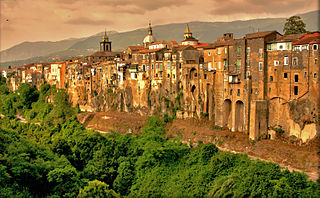
Sant'Agata de' Goti is a comune (municipality) and former Catholic bishopric in the Province of Benevento in the Italian region Campania, located about 35 km northeast of Naples and about 25 km west of Benevento near the Monte Taburno.

Vitulano is a comune (municipality) in the Province of Benevento in the Italian region Campania, located about 50 km northeast of Naples and about 12 km northwest of Benevento.

The Matese is a chain of mountains in southern Apennines, southern Italy.

Taburno Camposauro is a massif located in the Apennines, to the west of Benevento, in the Campania region of Southern Italy. Its highest peak is the Taburno, at 1,393 m. It is composed of two groups of calcareous mountains separated by a plain. The fauna is affected by human activities, but the birdlife is very diverse. Several historical structures, mainly religious, are located on the massif. A DOC wine is produced in the area.

Valle Latina is an Italian geographical and historical region that extends from south of Rome to Cassino, corresponding to the eastern area of ancient Roman Latium.

The Monti Picentini Regional Park is a natural preserve in Campania, southern Italy.

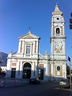
The Sanctuary of the Virgin of Taburnus, also known as Sanctuary of Saint Mary of Mount Taburno, is a religious structure built at the end of the 15th century at the foot of Mount Taburno. It is located in the comune of Bucciano, in the province of Benevento of Southern Italy. For more than two hundred years it was used by Dominican friars.
The Naples–Foggia railway is an Italian railway line connecting Naples, in Campania, with Foggia, in Apulia, crossing the Apennines at the saddle of Ariano through a series of tunnels.