
Dhankuta District is one of 14 districts of Province No. 1 of eastern Nepal. The district covers an area of 891 Km² and has a population (2011) of 163,412. Dhankuta is the district headquarters of Dhankuta District.

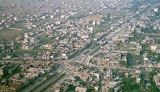
Itahari is a sub-metropolitan city of seven municipalities located in the Sunsari District of Province No. 1 of Nepal.

Dalchoki(Nepali: दलचोकी) is a village and former Village Development Committee that is now part of Konjyosom Rural Municipality in Province No. 3 of central Nepal. It is situated on the southern part of Lalitpur district, nearly 23 Kilometers from Patan, its district headquarters. This hilly region ranges from 1200 to 2300 meters from the sea level. At the time of the 1991 Nepal census it had a population of 1066 in 193 individual households.
Mangalbare is a town located in the Deumai Municipality in Ilam District in the Mechi Zone of eastern Nepal. At the time of the 1991 Nepal census it had a population of 5,593 persons living in 1005 individual households.Now, Mangalbare and dhuseni have become municipality combinedly & has been named as Deumai municipality. There are many beautiful places like panitar, gajurmukhi, Deumai river, Gufathumki, etc. People are engaged in Agriculture & some owns shop. Mangalbare bazaar is the hub centre for the neighbors like jitpur, dhuseni, shanti danda, sangrumba, Phuyetappa,etc. This area is very fertile for the commercial crops such as cardamom, tea, ginger, as well as many horticultural commodities.
Shantinagar is a town and Village Development Committee in Dang Deokhuri District in the Rapti Zone of south-western Nepal. At the time of the 1991 Nepal census it had a population of 8,854.
Kharanitar is a village development committee in Nuwakot District in the Bagmati Zone of central Nepal. At the time of the 1991 Nepal census it had a population of 1524 living in 298 individual households.

Dudhauli is a municipality of the Sindhuli District in the Janakpur Zone of south-eastern Nepal.
Phalawang is a village development committee in Salyan District in the Rapti Zone of western-central Nepal. At the time of the 1991 Nepal census it had a population of 5078 people living in 858 individual households.
Itahari Bishnupur is a village development committee in Saptari District in the Sagarmatha Zone of south-eastern Nepal. At the time of the 2011 Nepal census it had a population of 6,335 people living in 1,269 individual households.
Nargho is a village development committee in Saptari District in the Sagarmatha Zone of southeastern Nepal. At the time of the 1991 Nepal census it had a population of 4640 people living in 960 households. Different caste people like jha, yadav, mandal, sha, ram, karn, paswan, sharma, dom, shada etc., used to live in village. It consists of four subvillages. It has three small bazaars but it does not have good road facility. Most of the people are farmers and they grow paddy, wheat, pulses, vegetables, etc. Some of the people used to depend on animal husbandry and fishery to survive.
Duhabi is a municipality in Sunsari District in the Koshi Zone of south-eastern Nepal. At the time of the 2001 Nepal census it had a population of 17,574. Duhabi is situated in between Itahari and Biratnagar, on the bank of Budi River. It is the center of Sunsari–Morang industrial corridor. Originally, it was called Duhabi-bhaluwa municipality but now its name is Duhabi.
Khanar is a town in Itahari in Sunsari District in the Koshi Zone of south-eastern Nepal. The VDC village development committee was merged to form the submetropolis in June 2014. At the time of the 2011 Nepal census it had a population of 20,323 people living in 5,130 individual households. It lies 4 km south from Itahari Municipality and 6 km north from Duhabi vdc. Khanar is an industrial vdc with hundreds of industries. It is divided into 9 wards.
Barah Nagarpalika is a Municipality in Sunsari District in the Kosi Zone of south-eastern Nepal. Situated nearby the Koshi River. Most of the residents, as is common in Nepal, depend on agriculture but in the last few years the trend of going to the gulf countries as workers is increasing. The Town is yet to have any prominent business house but is a growing market with a number of small industries, hotels and shops. Being linked with some major cities Dharan & Itahari of the Sunsari District, this Town holds a very good chance of development. There is one community radio station also, named Sunsari FM… There are number of schools and a higher secondary school in the Town and almost all the children go to primary school and higher school. But the fraction of students continuing their studies to higher level is somehow not too great because of the low economic status of the people.
Pakali was a village development committee in Sunsari District in the Koshi Zone of south-eastern Nepal but now it's part of Sub-metropolitan city Itahari. Earlier, it lies between Itahari and Jhumkaa. It has a famous temple of Goddess Bhawani called as (Jabdi). At the time of the 1991 Nepal census it had a population of 9500. Now, Itahari is a sub-metropolitan city.
Urlabari is a town and municipality in Morang District in the Koshi Zone of south-eastern Nepal which is considered as the second largest city in Morang District after Biratnagar. At the time of the 1991 Nepal census it had a population of 18224. At the time of the 2011 Nepal census it had a population of 35,166 and 8,165 households.

Kawasoti (कावासोती) is a municipality in Nawalpur District, Gandaki province, Nepal. It is 31 km west of Bharatpur and 85 km (53 mi) east of Butwal, approximately on the middle of Mahendra Highway. The Naryani River flows south of it, and the Mahabharat Range is north of it.
Labipur is a Tharu village located in the Itahari sub-metropolitan city of Sunsari District in the Koshi Zone of south-eastern Nepal.
Satterjhora, a village development committee in Sunsari District in the Koshi Zone of south-east Nepal. Its population (2011) was 9,507 in 1,889 households. Among them the male and female population was about 4,539 and 4,968 respectively.

Buddhashanti is a rural municipality (gaunpalika) out of seven rural municipality located in Jhapa District of Province No. 1 of Nepal. There are a total of 15 municipalities in Jhapa in which 8 are urban and 7 are rural.


