The Tagus is the longest river in the Iberian Peninsula. The river rises in the Montes Universales near Teruel, in mid-eastern Spain, flows 1,007 km (626 mi), generally westward, and empties into the Atlantic Ocean in Lisbon.

The Guadiana River is an international river defining a long stretch of the Portugal-Spain border, separating Extremadura and Andalusia (Spain) from Alentejo and Algarve (Portugal). The river's basin extends from la Mancha and the eastern portion of Extremadura to the southern provinces of the Algarve; the river and its tributaries flow from east to west, then south through Portugal to the border towns of Vila Real de Santo António (Portugal) and Ayamonte (Spain), where it flows into the Gulf of Cádiz. With a course that covers a distance of 829 kilometres (515 mi), it is the fourth-longest in the Iberian Peninsula, and its hydrological basin extends over an area of approximately 68,000 square kilometres (26,000 sq mi).

The Manzanares is a river in the centre of the Iberian Peninsula, which flows from the Sierra de Guadarrama, passes through Madrid, and eventually empties into the Jarama river, which in turn is a right-bank tributary to the Tagus.
Soto del Real, whose former name was Chozas de la Sierra, is a town and municipality in the northern area of the autonomous Community of Madrid which had 9,188 inhabitants in 2022.

The Sierra de Guadarrama is a mountain range forming the main eastern section of the Sistema Central, the system of mountain ranges along the centre of the Iberian Peninsula. It is located between the systems Sierra de Gredos in the province of Ávila, and Sierra de Ayllón in the province of Guadalajara.

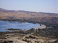
Manzanares el Real is a town in the north of the autonomous Community of Madrid. It is located at the foot of La Pedriza, a part of the Sierra de Guadarrama, and next to the embalse de Santillana. In 2020, the town had 8,936 inhabitants.
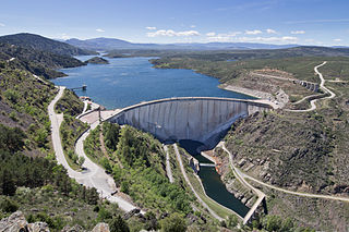
El Atazar Dam is an arch dam built near Madrid, Spain on the Lozoya River, very close to where the Lozoya joins the Jarama. The curved design of the dam is optimum for the narrow gorge in which it was built to retain water in the reservoir. Arch dams are thin and require less material to construct than other dam types.

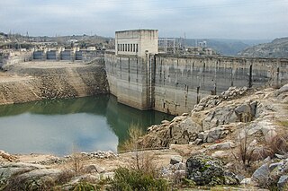
The Almendra Dam, also known as Villarino Dam, in Salamanca, Spain, interrupts the course of the River Tormes five kilometres from the village from which it takes its name: Almendra. It was constructed between 1963 and 1970.

The García Sola Reservoir is a reservoir located in the town of Castilblanco in the autonomous community of Extremadura, Spain.

The Alarcón Dam is a gravity dam on the upper course of the Júcar River. It is located 6 kilometres (3.7 mi) from Alarcón, in the province of Cuenca, in the autonomous community of Castilla-La Mancha, Spain.

Bolarque Dam is a concrete gravity dam on the Tagus in Spain, where the river forms the border between the provinces of Cuenca and Guadalajara. About 6 km downstream from the dam is the José Cabrera Nuclear Power Station.

Mequinenza Dam is a concrete gravity dam in the province of Zaragoza, Spain. It impounds the Ebro creating a large reservoir, which is called Mar de Aragón. About 35 km downstream of Mequinenza dam is Ribarroja dam.
Ribarroja Dam is a concrete gravity dam located in the province of Tarragona, Spain, that impounds the Ebro. About 35 km upstream of Ribarroja dam is Mequinenza dam. About 15 km downstream is Flix dam.
The Cerrón Grande Reservoir, also known locally as Lake Suchitlán, is a reservoir in northern El Salvador and the largest body of fresh water in the country. The reservoir was filled between 1973 and 1976, subsequent to the construction of the Cerrón Grande Hydroelectric Dam. The Cerrón Grande Reservoir is among the most polluted bodies of fresh water in Central America.

Madrid Río is an urban park in the Spanish capital Madrid, built along an urban stretch of the Manzanares River following the burial of the M-30 bypass road in this area. It is the result of a project led by the architect Ginés Garrido, who won the international ideas competition organised by the Madrid City Council in 2005 to redevelop the area.

The Yesa Reservoir is located in the Pyrenees, and is formed with the damming of the Aragon River, in the Navarre town of Yesa (Spain), although the largest area of the reservoir is located in the province of Zaragoza, extending from east to west. It is located to the northwest of the Aragonese province of Zaragoza and to the east of Navarre. Most of it floods lands of the Berdun Canal, in the Aragonese region of Jacetania in the municipalities of Sigüés, Ruesta, Escó, and Tiermas. It is known by the nickname Mar de los Pirineos and is located at the entrance of the aforementioned. It is the largest navigable area of Aragon and it is the source of the Bardenas Canal that transfers water to the Ribera area south of Navarra and irrigates the Bardenas Reales and the Cinco Villas region of Zaragoza. It is also used for water supply and as a power station.

The Cuenca Alta del Manzanares Regional Park, created in 1985, is the natural space protected area with the largest extension in the Community of Madrid (Spain) and one of the most ecologically and scenically valuable. It is located in the northwest of the region and extends around the upper course of the Manzanares River, along 42 583 ha. Its main municipalities of reference are Manzanares el Real and Hoyo de Manzanares. Unesco declared it a Biosphere Reserve in 1992.

The Sierra de Hoyo or Sierra de Hoyo de Manzanares is a mountain chain located in the northwest of the Community of Madrid (Spain), near the Sierra de Guadarrama. Geologically it belongs to this mountainous formation, but there is a flat separation of about ten kilometers between the two. Its main municipality of reference is Hoyo de Manzanares, located on its southern slope, from which it takes its name.

The Tagus Basin is the drainage basin of the Tagus River, which flows through the west of the Iberian Peninsula and empties into Lisbon. It covers an area of 78,467 km2, which is distributed 66% on Spanish territory and 34% on Portuguese land (22,822 km2).
The Ricobayo Dam is a hydroelectric engineering work built on the lower course of the Esla river. It is located less than 1 km from Ricobayo de Alba, in the province of Zamora, Castilla y León, Spain.