Sanyati

Last updated

Sanyati
Town
Zimbabwe adm location map.svg
Red pog.svg
Sanyati
Sanyati located in Zimbabwe Map
Coordinates: 17°57′00″S29°18′27″E / 17.95000°S 29.30750°E / -17.95000; 29.30750
Country Zimbabwe
Province Mashonaland West
District Kadoma District
CitySanyati Municipality
Elevation
850 m (2,790 ft)
Population
 (2004 Estimate)
  Total2,918
Time zone UTC+2 (CAT)
Climate Cwa

Sanyati is a town in Zimbabwe.

Location

The town is located in Kadoma District, in Mashonaland West Province, in northern central Zimbabwe. This location is about 100 kilometres (62 mi), by road, northwest of the city of Kadoma, where the district headquarters are located. [1] Sanyati is located on the east bank of the Sanyati River, about 60 kilometres (37 mi), by road, northeast of the town of Gokwe, on the opposite side of the river. [2] The coordinates of Sanyati are: 17° 57' 0.00"S, 29° 18' 27.00"E (Latitude:17.9500; Longitude:29.3075).

Contents

Overview

The town of Sanyati and the surrounding sub-district known as Sanyati Subdistrict [3] lie in an area known as the Sanyati Tribal Trust Lands, which is a major cotton-producing area in Zimbabwe. The town is the location of Sanyati Baptist Mission. The mission owns and administers: (a) Sanyati Baptist Hospital (b) Sanyati Baptist Primary School and (c) Sanyati Baptist High School. In the central business district, the main activities include welding, carpentry and masonry. Activities related to farming (farm supply shops and produce purchase points) are also prevalent in the town. ZB Bank Limited, a commercial bank, and Share Wealth (Pvt) Ltd, a microfinance service, maintain branches in town. [4] The town is also served by Sanyati Baptist Mission Airport. A lodge is also available by the name Sanyati Rendezvous, located next to council offices.

History

Chenjiri farms is the home town of Fungai Chaderopa, who became the first Sanyati woman member of parliament in March 2008.

Population

In 2022, the population of the town was estimated at 139,235. [5] The current population of the town is not publicly known.

See also

Related Research Articles

<span class="mw-page-title-main">Midlands Province</span> Province in Zimbabwe

Midlands is a province of Zimbabwe. It has an area of 49,166 square kilometres (18,983 sq mi) and a population of 1,811,905 (2022). It is home to various peoples. Located at a central point in the country, it contains speakers of Shona, Ndebele, Tswana, Sotho and Chewa, as well as of various other languages. Gweru, the third-largest city in Zimbabwe, is the capital of the province.

<span class="mw-page-title-main">Gwanda</span> Zimbabwean town

Gwanda is a town in Zimbabwe. It is the capital of the province of Matabeleland South, one of the ten administrative provinces in the country. It is also the district capital of Gwanda District, one of the seven administrative districts in the province.

<span class="mw-page-title-main">West Nicholson</span> Zimbabwean town

West Nicholson or Tshabezi is a town in the Matabeleland South Province of Zimbabwe.

Juliasdale is a resort town in Manicaland, Zimbabwe. It is situated in the foothills of the Nyanga mountains in eastern Zimbabwe

Colleen Bawn is a town in Zimbabwe.

<span class="mw-page-title-main">Kadoma, Zimbabwe</span> Town in Mashonaland West, Zimbabwe

Kadoma, formerly known as Gatooma, is a town in Zimbabwe.

Karoi is a town in Zimbabwe.

Chinhoyi, previously known as Sinoia during the colonial era, is a city in central northern Zimbabwe in the Makonde District. It has a population of 90,800 and is primarily a college town, although it was originally founded as an Italian group settlement scheme. The nearby Chinhoyi Caves and national park are a popular attraction.

Mount Darwin is a town in Mashonaland Central province in Zimbabwe.

<span class="mw-page-title-main">Kwekwe District</span> District in Kwekwe, Zimbabwe

Kwekwe, originally known as Que Que, is a district in Zimbabwe. 197,062 people live in Kwekwe rural and 119,863 live in Kwekwe town.

Chipinge, formerly known as Chipinga, is a town in Zimbabwe, located in Chipinge District, in Manicaland Province, in southeastern Zimbabwe, close to the border with Mozambique.

Murombedzi is a town in Zimbabwe.

Kadoma District is a district in Zimbabwe.

<span class="mw-page-title-main">Gokwe North District</span> Region of Zimbabwe

Gokwe North District is the northern of two administrative districts in the Gokwe region of the Midlands province of Zimbabwe. Its administrative seat is Nembudziya.

<span class="mw-page-title-main">Kajjansi</span> Place in Central Uganda, Uganda

Kajjansi is a town in Central Uganda. It is one of the urban centers in Wakiso District.

<span class="mw-page-title-main">Zvimba District</span> Place in Mashonaland West, Zimbabwe

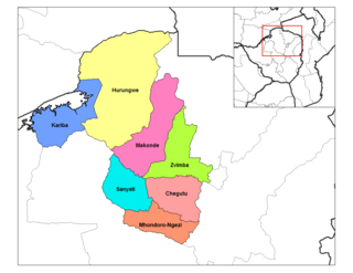
Zvimba District is a district of Mashonaland West Province, Zimbabwe.

Murambinda is a town in Zimbabwe.

The Kwekwe-Gokwe Highway or the R84-7 Highway is an all-weather bitumen macadam highway in Zimbabwe running from Kwekwe to Gokwe passing through Zhombe. As a trunk road it is officially designated as the P11 Highway.

The A5 Highway is a national road in Zimbabwe. It joins the cities of Harare and Bulawayo, and is hence known as the Harare-Bulawayo Highway. It is one of the two routes that form the R2 Route, which connects Harare with the Plumtree Border with Botswana.

<span class="mw-page-title-main">Mutange Dam</span> Dam in Midlands, Zimbabwe

Mutange Dam, across Mutange River, is a manmade earth fill embarkment dam located in Chisina Village, 30 km east of Gokwe and 35 km northwest of Empress Mine, in the Midlands Province of Zimbabwe. Mutange Dam is 42 km by road from Gokwe and 49 km from Empress, 117 km from Kadoma and 146 km from Kwekwe via Empress. It is owned and operated by the Ministry of Water Resources and Development.

References

  1. Road Distance Between Kaadoma And Sanyati With Map
  2. Map Showing Gokwe And Sanyati With Distance Marker
  3. A map of the subdistrict, labeled "Sanyati District Map", may be found at "Sanyati District Map" (PDF). United Nations Office for the Coordination of Humanitarian Affairs. 4 January 2010. Archived (PDF) from the original on 10 September 2016.
  4. List of Branches of ZB Bank Limited [ permanent dead link ]
  5. City Population website, Sanyati, retrieved February 20, 2024