
Ratnagiri District is a district in the state of Maharashtra, India. The administrative headquarter of the district is located in the town of Ratnagiri. The district is 11.33% urban. The district is bounded by the Arabian Sea to the west, Sindhudurg district to the south, Raigad district to the north and Satara, Sangli and Kolhapur districts to the east. This district is part of Konkan division.
Sindhudurg district is an administrative district of the Konkan division in India, which was carved out of the erstwhile Ratnagiri district. The district headquarters are located at Oros. The district occupies an area of approximately 5,207 km2 and has a population of 849,651, of which 12.59% were urban. As of 2011, it is the least populous district of Maharashtra.
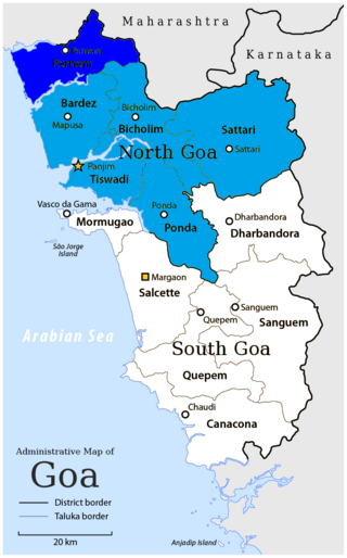
Pernem is a northmost administrative region or sub-district in North Goa in India. It acts as the Gateway of Goa from Maharashtra side. It is also the name of the town of Pernem, which is its headquarters. It has a Municipal Council. Geographically, Pernem is surrounded by Sawantwadi sub-district on East, Arabian Sea on West, Bardez and Bicholim sub-district on south and Sawantwadi sub-district on north. The two rivers which decide the boundary of this sub-district are Terekhol River and Chapora River. Terekhol river acts as a border of Maharashtra and Goa while Chapora river acts as a border of Pernem sub-district and Bardez sub-district.

Furus also known as Phuroos or Furoos is a village in Ratnagiri district, Maharashtra state in Western India. The 2011 Census of India recorded a total of 3255 residents in the village with total area 1062.35 hectares. It is predominantly populated by Konkani Muslims along with Hindu and Buddhist. Furus is believed to be named by Persians who came here to trade in horses. The main language spoken in Furus is Kokni, a blend of Bankoti, Sangameshwari and Marathi infused with words of Arabic, Urdu and Persian origin.

Chiplun ( [t͡ʃipɭuːɳ]) is a city in Ratnagiri district in the state of Maharashtra, India. It is one of the financial and commercial Hubs of Ratnagiri district, and the headquarters of Chiplun taluka. It is about 250 km south of Mumbai and 90 km North of Ratnagiri in the Konkan region of Maharashtra, on the Mumbai–Goa highway (NH-66). It has a long history and a strong cultural background. Recent decades have seen much industrial development in it and its and surrounding areas.

Kurang is a small village in the Ratnagiri district of Maharashtra in India. Ratnagiri is a coastal district on the Arabian Seafront.
Mandangad is the headquarters of Mandangad taluka the northmost taluka in Ratnagiri district of Maharashtra, India.
Sangameshwar Taluka is a taluka in Ratnagiri subdivision of Ratnagiri district in the Indian state of Maharashtra. The headquarters for the taluka is the town of Devrukh. In Sangameshwar the two rivers Sonavi and Shastri flow together. The meaning of Sangama in Marathi is "confluence," and so the name "Sangameshwar". It is historically important as the place where Chhatrapati Sambhaji, son of Chhatrapati Shivaji was captured by Mughal Emperor Aurangzeb. Chhatrapati Sambhaji was tortured and executed in Tulapur.

Asoli is a small village in Taluka Vengurla and district Sindhudurg of Maharashtra, India.
Ajgaon is a village in the state of Maharashtra, India. It is located in the Sawantwadi taluk of Sindhudurg district in Maharashtra.

Pondataluka is a subdivision of the district of north Goa, in the Indian state of Goa. Its administrative headquarters is the township of Ponda.
Ratnagiri taluka is a taluka in Ratnagiri district of Maharashtra an Indian state.
Rajapur taluka is a taluka in Ratnagiri district of Maharashtra an Indian state. The temple of Aryadurga devi is located in the Devihasol village in Rajapur taluka.
Lanja taluka is a taluka in Ratnagiri district of Maharashtra an Indian state.
Chiplun taluka is a taluka in Ratnagiri district of Maharashtra, India. As per Census 2011, there are 2 towns and 165 villages within Chiplun Taluka.
Guhagar taluka is a taluka in Ratnagiri district of Maharashtra an Indian state.
Khed taluka, Ratnagiri is a taluka in Ratnagiri district of Maharashtra an Indian state.
Mandangad taluka is a taluka in Ratnagiri district of Maharashtra an Indian state.
Mugij is a small village in Ratnagiri district, Maharashtra state in Western India. The 2011 Census of India recorded a total of 570 residents in the village. In Mugij there are three primary schools one is Urdu medium and another are Marathi medium. In Mugij there are many religions people are living like Hindu Muslim and Buddha. Mugij's geographical area is 256 hectares.
