Related Research Articles

The Cascade Range or Cascades is a major mountain range of western North America, extending from southern British Columbia through Washington and Oregon to Northern California. It includes both non-volcanic mountains, such as the North Cascades, and the notable volcanoes known as the High Cascades. The small part of the range in British Columbia is referred to as the Canadian Cascades or, locally, as the Cascade Mountains. The latter term is also sometimes used by Washington residents to refer to the Washington section of the Cascades in addition to North Cascades, the more usual U.S. term, as in North Cascades National Park. The highest peak in the range is Mount Rainier in Washington at 14,411 feet (4,392 m).

Yakima County is a county in the U.S. state of Washington. As of the 2020 census, its population was 256,728. The county seat and largest city is Yakima. The county was formed out of Ferguson County in January 1865 and is named for the Yakama tribe of Native Americans.
Clark Township is a civil township of Mackinac County in the U.S. state of Michigan. As of the 2010 census, the township population was 2,256.
Benton is a town in Polk County, Tennessee, United States. The population was 1,532 at the 2020 census. It is the county seat of Polk County.

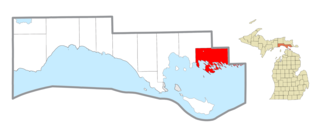
Satus is a census-designated place (CDP) in Yakima County, Washington, United States, located on the eastern corner of the Yakama Indian Reservation. The population was 746 at the 2000 census. It is southwest from the Toppenish National Wildlife Refuge. The community was not recognized in the 2010 census. The area was first settled and established as a post office location in 1890.
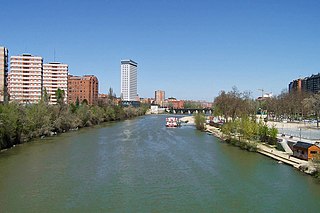
The Pisuerga is a river in northern Spain, the Duero's second largest tributary. It rises in the Cantabrian Mountains in the province of Palencia, autonomous region of Castile and León. Its traditional source is called Fuente Cobre, but it has been discovered that the real source is a glacier higher in the mountains. The river flows south into the Douro river shortly after passing through the city of Valladolid. Its length is approximately 270 kilometres (170 mi).

Mazama is an unincorporated community in Okanogan County located in the Methow Valley of Washington, on the east slopes of the North Cascades and North Cascades National Park. It is located along the North Cascades Highway, 14 miles (23 km) northwest of Winthrop and about 28 miles (45 km) south of the Canada–United States border. Mazama's town center elevation is 2,106 feet (642 m), and it is located 2.7 miles (4.3 km) south of and 4,895 feet (1,492 m) below Goat Peak.
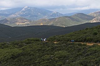
Cuyamaca is a region of eastern San Diego County. It lies east of the Capitan Grande Indian Reservation in the western Laguna Mountains, north of Descanso and south of Julian. Named for the 1845 Rancho Cuyamaca Mexican land grant, the region is now dominated by the 26,000-acre (110 km2) Cuyamaca Rancho State Park. Within the park is the prominent Cuyamaca Peak, the second-highest mountain in San Diego County at 6,512 feet (1,984.9 m).

The Wenatchee Mountains are a range of mountains in central Washington State, United States of America. A major subrange of the Cascade Range, extending east 50 miles (80 km) from the Cascade crest, the Wenatchee Mountains separate the drainage basins of the Yakima River from the Wenatchee River. The crest of the range forms part of the boundary between Chelan and Kittitas Counties.
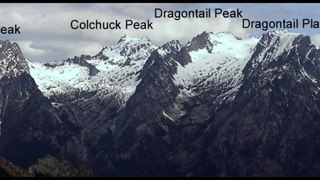
The Stuart Range is a mountain range in central Washington, United States. The range lies within the eastern extent of the Cascade Range immediately southwest of Leavenworth and runs east–west. The western peaks make up a single sharp ridge. The eastern half of the range splits into two parallel ridges, the northern of which is known as the Enchantment Peaks. Between these ridges lies the Enchantment Basin, which holds the dozens of tarns known as the Enchantment Lakes. Collectively, the basin and the encircling eastern peaks of the Stuart Range make up The Enchantments, a well-known backpacking destination. The south face of the Stuart Range falls off steeply to Ingalls Creek, beyond which rise the roughly parallel Wenatchee Mountains.

Washington Pass and Rainy Pass are two mountain passes on State Route 20 in the North Cascades mountains of Washington state. Rainy Pass is about 4 miles to the west of Washington Pass. The passes are typically closed between November and April due to heavy snowfall.

Ptarmigan Traverse is an alpine climbing route in the North Cascades of Washington state. The route, from Cascade Pass to Dome Peak, is generally remote, unmarked, and challenging, traversing rugged terrain and several glaciers.
The Yakima Valley AVA was the first American Viticultural Area established within Washington state, gaining the recognition in 1983. Part of the larger Columbia Valley AVA, Yakima Valley AVA is home to more than 18,000 acres (73 km2) of vineyards, giving the area the largest concentration of wineries and vineyards in the state. The most widely planted varietals in the area are Chardonnay, Riesling, Merlot, Cabernet Sauvignon, Pinot gris, and Syrah. Nearly 40% of Washington state yearly wine production is made from Yakima Valley grapes. In addition to grapes, the Yakima Valley is also home to several fruit orchards growing apples, cherries, nectarines, peaches, pears and plums. Around the town of Zillah, there is the Zillah Fruit Loop driving tour through the area's orchards and vineyards. The area is also home to nearly 80% of the US hop production.

The Napeequa River is a 19-mile (31 km) long river in the U.S. state of Washington on the east side of the Cascade Range. It rises in northwest Chelan County and flows southwest into the White River near Twin Lakes. The White River flows into Lake Wenatchee. The Napeequa River and its valley are notable for their beauty and isolation, as well as their interesting geological history. It flows through an isolated southeast-trending valley characterized by a broad meadows surrounded by rugged mountains. The Chiwawa Mountains, or Chiwawa Ridge mark the east side of the valley, separating the Napeequa and Chiwawa Rivers. To the west the White Mountains separate the Napeequa from the White River. Both are sub-ranges of the Cascade Range.

The Saddle Mountains consists of an upfolded anticline ridge of basalt in Grant County of central Washington state. The ridge, reaching to 2,700 feet, terminates in the east south of Othello, Washington near the foot of the Drumheller Channels. It continues to the west where it is broken at Sentinel Gap before ending in the foothills of the Cascade Mountains.

Snoqualmie Pass is a mountain pass that carries Interstate 90 (I-90) through the Cascade Range in the U.S. state of Washington. The pass summit is at an elevation of 3,015 feet (919 m), on the county line between Kittitas County and King County.

The Columbia Hills are an area of hills and small mountains along the north bank of the Columbia River in Klickitat County, in south-central Washington (state), USA. They have a maximum elevation of 2,667 feet (813 m).
Snipes Mountain AVA is an American Viticultural Area located in the Yakima Valley of Washington State. It was approved by the Bureau of Alcohol, Tobacco, Firearms and Explosives on January 21, 2009 making it Washington's 10th federally designated AVA. It is the second smallest AVA in the state, after the Red Mountain AVA, and has one of the state's longest viticultural histories. The 4,145 acres (1,677 ha) appellation is a sub-AVA of the Yakima Valley AVA and the Columbia Valley AVA. It is located above and between the towns of Sunnyside and Granger around Outlook, Washington, in the southeast corner of the Yakima Valley.
Teanaway is a small settlement in Kittitas County, Washington. It is located at the junction of State Route 10 and State Route 970. It is located east of Cle Elum and west of Ellensburg. The surrounding area is known as the Teanaway River Valley.
References
- ↑ Mueller, Marge; Mueller, Ted (2004). Washington State Parks: A Complete Recreation Guide. The Mountaineers Books. ISBN 978-0-89886-893-7.
- ↑ Program (Wash.), Writers' (1941). Washington: A Guide to the Evergreen State. Binfords & Mort.
Coordinates: 45°59′05″N120°39′13″W / 45.98472°N 120.65361°W
| | This Klickitat County, Washington state location article is a stub. You can help Wikipedia by expanding it. |