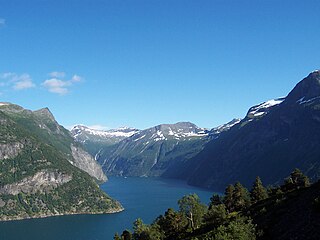
In physical geography, a fjord or fiord is a long, narrow sea inlet with steep sides or cliffs, created by a glacier. Fjords exist on the coasts of Antarctica, the Arctic, and surrounding landmasses of the northern and southern hemispheres. Norway's coastline is estimated to be 29,000 km (18,000 mi) long with its nearly 1,200 fjords, but only 2,500 km (1,600 mi) long excluding the fjords.
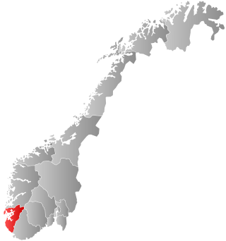
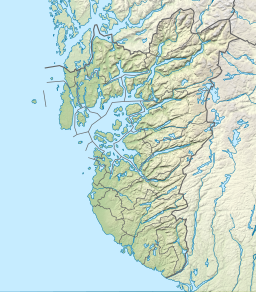
Rogaland is a county in Western Norway, bordering the North Sea to the west and the counties of Vestland to the north, Telemark to the east and Agder to the east and southeast. As of 1 January 2024, it had a population of 499,417 people.
Sauda is a municipality in Rogaland county, Norway. The administrative centre of the municipality is the city of Sauda, where most of the population lives. Other villages in the municipality include Saudasjøen and Amdal. Despite being in the northern part of the region of Ryfylke, Sauda participates in the Haugalandet Council and is under the jurisdiction of the Haugaland og Sunnhordland District Court.
Etne is a municipality in Vestland county, Norway. It is located in the traditional district of Sunnhordland, although it is also sometimes considered to be part of the district of Haugaland. The administrative centre of the municipality is the village of Etnesjøen. Other villages in the municipality include Skånevik and Fjæra. The two largest villages in the municipality are Etnesjøen with 1,159 residents and Skånevik with 594 residents.

Lysefjord or Lysefjorden is a fjord located in the Ryfylke area in Rogaland county in southwestern Norway. The 42-kilometre (26 mi) long fjord lies in the municipalities of Strand and Sandnes, about 25 kilometres (16 mi) east of the city of Stavanger.

Ryfylke is a traditional district in the northeastern part of Rogaland county, Norway. The 4,546-square-kilometre (1,755 sq mi) district is located northeast of the city of Stavanger and east of the city of Haugesund and it encompasses about 60% of the county's area. It includes the mainland located northeast and east of the Boknafjorden and east of the Høgsfjorden. It also includes the islands located on the south side of the Boknafjorden. To the east, Ryfylke borders the districts of Setesdal and Sirdal, to the south is Jæren, and to the west is Haugalandet. Ryfylke is one of the 15 districts in Western Norway.
Western Norway is the region along the Atlantic coast of southern Norway. It consists of the counties Rogaland, Vestland, and Møre og Romsdal. The region has no official or political-administrative function. The region has a population of approximately 1.4 million people. The largest city is Bergen and the second-largest is Stavanger. Historically the regions of Agder, Vest-Telemark, Hallingdal, Valdres, and northern parts of Gudbrandsdal have been included in Western Norway.
Boknafjord or Boknafjorden is a fjord located in Rogaland county, Norway. The huge fjord lies between the cities of Stavanger and Haugesund and dominates the central part of the county. The main part of the fjord is shared between the municipalities of Kvitsøy, Stavanger, Tysvær, Bokn, and Karmøy. There are dozens of smaller fjords that branch off the main part of the fjord, reaching most municipalities in the county. At its longest, the Boknafjord reaches about 96 kilometres (60 mi) into the mainland at the innermost point of the Hylsfjorden. Other notable branches include the Saudafjorden, Sandsfjorden, Vindafjorden, Hervikfjorden, Førresfjorden, Erfjorden, Jøsenfjorden, Årdalsfjorden, Idsefjorden, Høgsfjorden, Lysefjorden, and Gandsfjorden.
Vostervatnet is a lake in the municipality of Strand in Rogaland county, Norway. The 2.62-square-kilometre (1.01 sq mi) lake lies in the northwestern part of Strand, just south of the Fognafjorden. The village of Tau lies about 3.5 kilometres (2.2 mi) southwest of the lake. The main outflow of the lake is the river Fiskåna, which flows north from the northeastern corner of the lake, down the hill to the village of Fiskå on the shore of the fjord.
Saudasjøen is a village in Sauda municipality in Rogaland county, Norway. The village is located along the northern coast of the Saudafjorden about 3.5 kilometres (2.2 mi) southwest of the town of Sauda. For statistical purposes it is considered a part of the urban area of the town of Sauda. The village is mostly a bedroom community for the nearby town of Sauda. There are some small industries in Saudasjøen as well as the Saudasjøen Chapel. County Road 520 runs through the village along the shore of the fjord.
Hellandsbygda or Hellandsbygd is a village in Sauda municipality in Rogaland county, Norway. The village is located in a river valley about 12 kilometres (7.5 mi) northeast of the town of Sauda. The village is surrounded by forested mountains with the County Road 520 running through the village on its way from Sauda over the mountains to the Røldal area in neighboring Vestland county. The mountain Kyrkjenuten lies to the north of Hellandsbygda and the mountain Skaulen lies to the southeast of the village.

Sandsfjorden or Sandsfjord is a fjord in Suldal Municipality in Rogaland county, Norway. The 25-kilometre (16 mi) long fjord is the northernmost arm of main Boknafjorden in Rogaland county. The fjord begins at the confluence of the Saudafjorden and Hylsfjorden, just north of the village of Sand. It then travels to the southwest until it reaches the island of Foldøy, where the fjord joins the main Boknafjorden. The villages of Jelsa and Hebnes are located on either side of the mouth of the fjord.
Amdal is a small farming village in Sauda municipality in Rogaland county, Norway. The village is located just a short distance inland from the Saudafjorden, about 1.5 kilometres (0.93 mi) north of the village of Saudasjøen and about 2.5 kilometres (1.6 mi) west of the town of Sauda.

Hylsfjorden or Hylsfjord is a fjord in the municipality Suldal in Rogaland county, Norway. The 20-kilometre (12 mi) long fjord runs from the small area of Hylen to the west. It ends just north of the village of Sand where it joins the Saudafjorden and together they form the Sandsfjorden, an inner branch of the Boknafjorden. The 160-megawatt (210,000 hp) Hylen Hydroelectric Power Station is located in the inner end of Hylsfjord. The fjord has relatively little development along its shores, only a few small hamlets, with Vanvik being the largest.

Skjoldafjorden is a fjord in Rogaland county, Norway. The 26-kilometre (16 mi) long fjord is a northern branch of vast Boknafjorden which dominates Rogaland county.

Etnefjorden is a fjord on the border between Vestland and Rogaland counties in Norway. The majority of the fjord lies in the municipality of Etne, but a small part of it also lies in the neighboring municipality of Vindafjord in Rogaland county. The 8.5-kilometre (5.3 mi) long fjord flows from the village of Etnesjøen to the west into the Skånevikfjorden/Hardangerfjorden. The fjord is fed by the Etneelva river which empties into the fjord at the village of Etnesjøen. The European route E134 highway runs along the inner part of the fjord.
Sauda is a town in Rogaland, Norway.
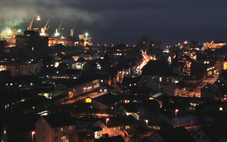
Sauda is a town in Sauda municipality in Rogaland county, Norway. The town, which is also the administrative centre of the municipality, is located in a river valley at the northern end of the Saudafjorden. The small suburb of Saudasjøen lies about 3 kilometres (1.9 mi) west of the town centre. A large part of the industrial harbour area of Sauda is built on reclaimed land that was once underwater in the fjord.

Byfjorden is a fjord in Rogaland county, Norway. The 10-kilometre (6.2 mi) long fjord runs through the municipalities of Randaberg and Stavanger. The fjord begins at the Tungenes Lighthouse at the northern end of the Stavanger Peninsula and it flows south along the east side of the peninsula to the city of Stavanger. The islands of Bru, Åmøy, Hundvåg, Buøy, Engøy, Sølyst, and Grasholmen lie along the east side of the fjord. The fjord connects to the Boknafjorden at the north end.

Åna-Sira is a village in southwestern Norway, sitting mostly in Sokndal municipality in Rogaland county, but a small portion lies in Flekkefjord municipality in Agder county. The village is located at the mouth of the river Sira where it flows south into Åna fjord. The fjord and river form the county border with Rogaland and Agder counties. The Åna-Sira Bridge crosses the river connecting the two parts of the village. The village is the southernmost village in Rogaland county.