Sauk Rapids Regional Bridge

Last updated
Sauk Rapids Regional Bridge
SaukRapidsRegionalBridge.jpg
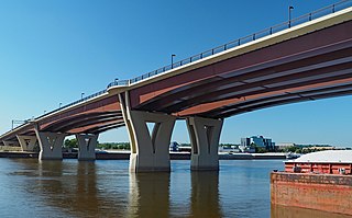
Construction of the Sauk Rapids Regional Bridge as of August 18, 2006, shown from the west bank of Mississippi River, south of the bridge.
Coordinates 45°35′17″N94°10′12″W / 45.58806°N 94.17000°W / 45.58806; -94.17000
CarriesFour lanes connecting Second Street North (Benton CSAH 3), Sauk Rapids, MN and Ninth Avenue North, St. Cloud, MN, pedestrians
Crosses Mississippi River, BNSF Railway
Locale Sauk Rapids, Minnesota
Official nameSauk Rapids Regional Bridge
Maintained by Stearns County, City of Sauk Rapids
ID number 05534
Characteristics
Design Plate girder bridge
History
OpenedOctober 23, 2007

The Sauk Rapids Regional Bridge is a bridge spanning the Mississippi River in the U. S. city of Sauk Rapids, Minnesota. Construction began on September 26, 2005; the bridge was completed in September 2007 and opened to traffic on October 23, 2007. The official dedication and ribbon-cutting ceremony took place on November 16, 2007. The bridge replaced the former Sauk Rapids Bridge, located a short distance downriver, which was demolished in the fall and winter of 2007-2008.

Mississippi River largest river system in North America

The Mississippi River is the second-longest river and chief river of the second-largest drainage system on the North American continent, second only to the Hudson Bay drainage system. Its source is Lake Itasca in northern Minnesota and it flows generally south for 2,320 miles (3,730 km) to the Mississippi River Delta in the Gulf of Mexico. With its many tributaries, the Mississippi's watershed drains all or parts of 32 U.S. states and two Canadian provinces between the Rocky and Appalachian mountains. The main stem is entirely within the United States; the total drainage basin is 1,151,000 sq mi (2,980,000 km2), of which only about one percent is in Canada. The Mississippi ranks as the fourth-longest and fifteenth-largest river by discharge in the world. The river either borders or passes through the states of Minnesota, Wisconsin, Iowa, Illinois, Missouri, Kentucky, Tennessee, Arkansas, Mississippi, and Louisiana.

Sauk Rapids, Minnesota City in Minnesota, United States

Sauk Rapids is a city in Benton County, Minnesota, United States. The population was 12,773 at the 2010 census and is 13,879 according to 2018 census estimates. It is located on a set of rapids on the Mississippi River near its confluence with the Sauk River.

Sauk Rapids Bridge

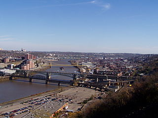
The Sauk Rapids Bridge was a steel spandrel braced arch bridge that spanned the Mississippi River between the cities of St. Cloud and Sauk Rapids in the U.S. state of Minnesota. It was built in 1942 and was designed by the Minnesota Department of Transportation. The bridge consisted of three spans supported by two piers. It crossed the Mississippi River one-half mile (0.8 km) downstream from the rapids of the Sauk River. The river is still rough and fast-flowing at this location.

The new bridge spans the BNSF Railway on the east bank of the river. Traffic flow is no longer disrupted during train crossings; this was a frequent problem with the former bridge.

BNSF Railway freight railroad network in North America

The BNSF Railway Company is the largest freight railroad network in North America. One of eight North American Class I railroads, BNSF has 44,000 employees, 32,500 miles (52,300 km) of track in 28 states, and more than 8,000 locomotives. It has three transcontinental routes that provide rail connections between the western and eastern United States. BNSF trains traveled over 169 million miles in 2010, more than any other North American railroad. The BNSF and Union Pacific have a duopoly on all transcontinental freight rail lines in the Western U.S. and share trackage rights over thousands of miles of track.

The new span relied heavily on steel for its construction rather than concrete to reduce the number of piers needed to be placed in the river. This design choice increased the project cost by $2.3 million USD to a total cost estimated at $56.63 million. Construction of the bridge of itself cost an estimated $20.46 million, with other costs including right-of-way purchases, road construction, and a program to help businesses affected by the project relocate elsewhere in downtown Sauk Rapids.

The entire project was large in scope, due to the amount of business and residential properties that were affected by its chosen location. When the Sauk Rapids Bridge project began, it was considered to be the first downtown transportation project of its kind nationwide in terms of the scale of relocations of businesses that were necessary. The success of the project may set a precedent for future bridges. [1]

The original design of the bridge was hotly contested between Benton County and the City of Sauk Rapids, and the dispute was nearly taken to court. The county had wished that the bridge land beyond Benton Drive (Sauk Rapids' "main street") on Second Avenue and connect with Second Street North. The city feared that such a design would adversely affect businesses in the downtown area and desired instead that the bridge land on Benton Drive. Benton County's stake in the project (Stearns County being the other contributor) was eventually handed over to the city, and it was elected that the bridge pass over the BNSF Railway, land on Benton Drive, and connect with Second Street North.

Benton County, Minnesota County in the United States

Benton County is a county in the U.S. state of Minnesota. As of the 2010 United States Census, the population was 38,451. Its county seat is Foley. Established in 1849 and organized in 1850, the county is one of the oldest in Minnesota. It was named for Thomas Hart Benton, a United States Senator from Missouri.

Stearns County, Minnesota County in the United States

Stearns County is a county in the U.S. state of Minnesota. As of the 2010 United States Census, the population was 150,642. Its county seat is Saint Cloud. The county was founded in 1855. It was originally named for Isaac Ingalls Stevens, then renamed for Charles Thomas Stearns.

The Sauk Rapids Regional Bridge features a spiral walkway on the Sauk Rapids side of the bridge that allows pedestrians to access the city parking lot under the bridge.

See also

Related Research Articles

Quad Cities Metropolitan area in the United States

The Quad Cities is a region of five cities in the U.S. states of Iowa and Illinois: Davenport and Bettendorf in southeastern Iowa, and Rock Island, Moline, and East Moline in northwestern Illinois. These cities are the center of the Quad Cities metropolitan area, which as of 2013 had a population estimate of 383,781 and a CSA population of 474,937, making it the 90th-largest CSA in the nation.

Swing bridge movable bridge that has a vertical locating pin and support ring about which the turning span can pivot horizontally

A swing bridge is a movable bridge that has as its primary structural support a vertical locating pin and support ring, usually at or near to its center of gravity, about which the turning span can then pivot horizontally as shown in the animated illustration to the right. Small swing bridges as found over canals may be pivoted only at one end, opening as would a gate, but require substantial underground structure to support the pivot.

Stan Musial Veterans Memorial Bridge bridge across the Mississippi River at St. Louis

The Stan Musial Veterans Memorial Bridge is a bridge across the Mississippi River between St. Clair County, Illinois, and the city of St. Louis, Missouri. Built between April 19, 2010, and July 2013, the bridge opened on February 9, 2014. The cable-stayed bridge has a main span of 1,500 feet (457 m).

Interstate Bridge highway bridge in Oregon and Washington, USA

The Interstate Bridge is a pair of nearly identical steel vertical-lift, "Parker type" through-truss bridges that carry Interstate 5 traffic over the Columbia River between Vancouver, Washington and Portland, Oregon in the United States.

10th Avenue Bridge bridge in Minneapolis, Minnesota

The 10th Avenue Bridge crosses the Mississippi River near downtown Minneapolis, Minnesota and also in proximity to the University of Minnesota. The bridge was formerly called the Cedar Avenue Bridge from days prior to the construction of the I-35W bridge when it connected to Cedar Ave. The bridge connects 10th Avenue Southeast, on the east side of the Mississippi River to 19th Avenue South, on the west side. The bridge is considered the crowning achievement of Minneapolis city engineer Kristoffer Olsen Oustad, who was one of four prominent Norwegian-American men who designed major structures in the region. It was added to the National Register of Historic Places in 1989, and also marks the downstream boundary of the Saint Anthony Falls Historic District. During the days immediately following the I-35W bridge collapse, the 10th Avenue Bridge was closed to traffic, then later reopened; it was one of the most used locations from which to view the wreckage and the recovery efforts.

Lafayette Bridge bridge in Saint Paul, Minnesota, United States of America

The Lafayette Bridge is a bridge carrying U.S. Route 52 across the Mississippi River in downtown Saint Paul, Minnesota. At this point, US 52 is on the Lafayette Freeway. The bridge spans across railroad yards north of the Mississippi, the river itself, and industrial areas south of the Mississippi. The Lafayette Bridge is one of the longest Mississippi River bridges in the Twin Cities.

Greenville Bridge bridge in United States of America

The Greenville Bridge is a cable-stayed bridge over the Mississippi River, in the United States, carrying US 82 and US 278 between Refuge, Mississippi, and Shives, Arkansas. When it opened in 2010, it was the fourth-longest cable-stayed bridge in North America.

Frisco Bridge rail bridge between West Memphis, Arkansas and Memphis, Tennessee

The Frisco Bridge, previously known as the Memphis Bridge, is a cantilevered through truss bridge carrying a rail line across the Mississippi River between West Memphis, Arkansas, and Memphis, Tennessee.

Hernando de Soto Bridge Steel-arch bridge in the United States

The Hernando de Soto Bridge is a through arch bridge carrying Interstate 40 across the Mississippi River between West Memphis, Arkansas, and Memphis, Tennessee. The archictectural design is a continuous cantilevered cable-stayed steel through arch, with bedstead endposts. Memphians also call the bridge the "New Bridge", as it is newer than the Memphis & Arkansas Bridge downstream, and the "M Bridge", due to its distinctive shape. It is of similar construction to the Sherman Minton Bridge between Louisville, Kentucky, and New Albany, Indiana.

Liberty Bridge (Pittsburgh) bridge over the Monongahela River in Pittsburgh, Pennsylvania

The Liberty Bridge, completed in 1928, connects downtown Pittsburgh, Pennsylvania, to the Liberty Tunnels and the South Hills neighborhoods beyond. It crosses the Monongahela River and intersects Interstate 579 at its northern terminus.

State Route 397 (SR 397) is a state highway in the U.S. state of Washington, serving the Tri-Cities region. It primarily functions as a truck route through industrial areas in Finley, Kennewick, and Pasco, running 22 miles (35 km) between junctions with Interstate 82 (I-82) and I-182. The highway crosses the Columbia River on the Cable Bridge, built in 1978 to replace an earlier bridge.

U.S. Route 90 Business (New Orleans, Louisiana) highway in New Orleans, Louisiana

U.S. Highway 90 Business is a business route of U.S. Highway 90 located in and near New Orleans, Louisiana. It runs 14.33 miles (23.06 km) in a general east–west direction from a point on US 90 between Avondale and Westwego to the junction of Interstate 10 (I-10) and US 90 in the New Orleans Central Business District.

M-231 is the designation of a state trunkline highway in the Lower Peninsula of the US state of Michigan that serves as a partial bypass to US Highway 31 (US 31) around Grand Haven. This highway was built south of Interstate 96 (I-96) as an additional crossing over the Grand River. The route runs from M-45 northward and across the river to a connection with I-96 near the current M-104 interchange.

1886 Sauk Rapids tornado

The 1886 Sauk Rapids Tornado was a violent tornado that tore through the cities of Sauk Rapids, St. Cloud, and Rice, Minnesota, on April 14, 1886. It destroyed much of the town of Sauk Rapids and killed 72 people along its path. It is the deadliest tornado on record in Minnesota. Other tornadoes occurred in Iowa, Kansas, Missouri, and Texas on the same day, suggesting the possibility of a large outbreak.

Circle Drive

Circle Drive is a major road constructed as a ring road in Saskatoon, Saskatchewan, Canada. The northeastern portion of the road is part of the Yellowhead Highway. It was first conceived in 1913 by the city commissioner and completed exactly 100 years later in 2013.

Sauvie Island Bridge

The Sauvie Island Bridge crosses the Multnomah Channel of the Willamette River near Portland, Oregon, United States. The original Parker truss bridge, built in 1950 with a 200-foot (61 m) main span, was replaced with a tied arch bridge with a 360-foot (110 m) span in 2008 due to cracks discovered in 2001.

US Highway 41 (US 41) is a part of the United States Numbered Highway System that runs from Miami, Florida, to the Upper Peninsula of the US state of Michigan. In Michigan, it is a state trunkline highway that enters the state via the Interstate Bridge between Marinette, Wisconsin, and Menominee, Michigan. The 278.769 miles (448.635 km) of US 41 that lie within Michigan serve as a major conduit. Most of the highway is listed on the National Highway System. Various sections are rural two-lane highway, urbanized four-lane divided expressway and the Copper Country Trail National Scenic Byway. The northernmost community along the highway is Copper Harbor at the tip of the Keweenaw Peninsula. The trunkline ends at a cul-de-sac east of Fort Wilkins State Park after serving the Central Upper Peninsula and Copper Country regions of Michigan.

Van Buren Street Bridge

The Van Buren Street Bridge is a swing span, steel motor vehicle bridge spanning the Willamette River at Corvallis in the U.S. state of Oregon. Opened in 1913, the black colored bridge was the first bridge across the river at Corvallis and is now the third oldest bridge across the river. Owned by the state and maintained by the Oregon Department of Transportation (ODOT), the 708-foot (216 m) long span is of a through truss design and carries one lane of traffic of Oregon Route 34 eastbound from Corvallis into neighboring Linn County. The bridge no longer is able to swing open.

References

  1. Ryan, Mackenzie (2005-09-18), "A Decade Later, It's Finally Happening", St. Cloud Times