The Mississippi River is the second-longest river and chief river of the second-largest drainage system on the North American continent, second only to the Hudson Bay drainage system. From its traditional source of Lake Itasca in northern Minnesota, it flows generally south for 2,320 miles (3,730 km) to the Mississippi River Delta in the Gulf of Mexico. With its many tributaries, the Mississippi's watershed drains all or parts of 32 U.S. states and two Canadian provinces between the Rocky and Appalachian mountains. The main stem is entirely within the United States; the total drainage basin is 1,151,000 sq mi (2,980,000 km2), of which only about one percent is in Canada. The Mississippi ranks as the fifteenth-largest river by discharge in the world. The river either borders or passes through the states of Minnesota, Wisconsin, Iowa, Illinois, Missouri, Kentucky, Tennessee, Arkansas, Mississippi, and Louisiana.

The Quad Cities is a region of five cities in the U.S. states of Iowa and Illinois: Davenport and Bettendorf in southeastern Iowa, and Rock Island, Moline, and East Moline in northwestern Illinois. These cities are the center of the Quad Cities metropolitan area, which as of 2013 had a population estimate of 383,781 and a Combined Statistical Area (CSA) population of 474,937, making it the 90th-largest CSA in the nation.

Benton County is a county in the East Central part of the U.S. state of Minnesota. As of the 2010 United States Census, the population was 38,451. Its county seat is Foley.

Rice is a city in Benton County, Minnesota, United States. The population was 1,275 at the 2010 census. Its zip code also encompasses Graham, Langola, and Watab townships.

Sauk Rapids Township is a township in Benton County, Minnesota, United States near the Mississippi River. The population was 584 at the 2010 census.

Sauk Rapids is a city in Benton County, Minnesota, United States. The population was 12,773 at the 2010 census and is 14,146 according to 2019 census estimates. It is located on a set of rapids on the Mississippi River near its confluence with the Sauk River.

Sartell is a city in Benton and Stearns counties in the state of Minnesota that straddles both sides of the Mississippi River. It is part of the St. Cloud Metropolitan Statistical Area. The population was 15,876 at the 2010 census and 18,926 according to 2019 estimates, making it St. Cloud's most populous suburb and fourth largest city in the central Minnesota region after St. Cloud, Elk River, and Willmar.

St. Cloud is a city in the U.S. state of Minnesota and the largest population center in the state's central region. Its population is 68,462 according to the 2019 US census estimates, making it Minnesota's tenth largest city. St. Cloud is the county seat of Stearns County and was named after the city of Saint-Cloud, France, which was named after the 6th-century French monk Clodoald.

The Stone Arch Bridge is a former railroad bridge crossing the Mississippi River at Saint Anthony Falls in downtown Minneapolis, Minnesota. It is the only arched bridge made of stone on the entire Mississippi River. It is the second oldest bridge on the river next to Eads Bridge. The bridge was built to connect the railway system to the new Union Depot, which at that time was planned to be built between Hennepin Avenue and Nicollet Avenue. The bridge was completed in 1883, costing $650,000 at the time. 117 Portland Avenue is the general address of the historic complex.

The Sauk River is a 122-mile-long (196 km) tributary of the Mississippi River in central Minnesota in the United States. It drains small lakes in Stearns County. In the Ojibwe language it is called Ozaagi-ziibi, meaning "River of the Sauks".
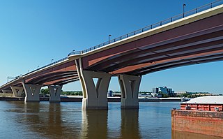
The Lafayette Bridge is a bridge carrying U.S. Route 52 across the Mississippi River in downtown Saint Paul, Minnesota. At this point, US 52 is on the Lafayette Freeway. The bridge spans across railroad yards north of the Mississippi, the river itself, and industrial areas south of the Mississippi. The Lafayette Bridge is one of the longest Mississippi River bridges in the Twin Cities.
The Dartmouth Bridge is a steel girder bridge that spans the Mississippi River in Minneapolis, Minnesota, between the Cedar-Riverside area and the University of Minnesota campus area. It carries I-94/US 12/US 52. It was built in 1964 and was designed by Parsons Brinckerhoff, Quade and Douglas. It is named for its proximity to Dartmouth Avenue SE, just north of the bridge.

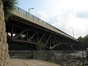
The Hastings High Bridge was a continuous steel through truss bridge that spanned the Mississippi River in Hastings, Minnesota, United States. It was designed by Sverdrup and Parcel and was built in 1951 by Graus Construction Company of Hasting for $356,000. It was demolished in late 2013 when a new bridge opened. It had been scheduled to be torn down and replaced by MNDot in 2019, but after the I-35W bridge collapse in Minneapolis, it was re-prioritized and construction started in 2010.

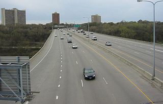
The I-35W Mississippi River bridge was an eight-lane, steel truss arch bridge that carried Interstate 35W across the Saint Anthony Falls of the Mississippi River in Minneapolis, Minnesota, United States. The bridge opened in 1967 and was Minnesota's third busiest, carrying 140,000 vehicles daily. It had a catastrophic failure during the evening rush hour on August 1, 2007, killing 13 people and injuring 145. The NTSB cited a design flaw as the likely cause of the collapse, noting that a too-thin gusset plate ripped along a line of rivets, and additional weight on the bridge at the time contributed to the catastrophic failure.

DeSoto Bridge was a trussed deck-arch bridge that spanned the Mississippi River in St. Cloud, Minnesota. It was built in 1958 by the Minnesota Department of Transportation. The bridge was painted black, which is typical for railroad bridges but unusual for a highway bridge. The river banks on either side are relatively high, so the bridge required deep trusses which arched over the river.

The Bridge of Hope is a concrete girder bridge that spans the Mississippi River between Sartell, Minnesota and Sauk Rapids, Minnesota. The bridge was completed eight months early, aided by favorable weather and trouble-free construction. It was built in 1995 and was designed by Minnesota Department of Transportation and the Jim Hill Group.
Minnesota State Highway 15 is a 154.322-mile-long (248.357 km) highway in south-central and central Minnesota, which runs from Iowa Highway 15 at the Iowa state line and continues north to its northern terminus at its interchange with U.S. Highway 10 outside of Sartell and Sauk Rapids, north of St. Cloud.

The Sauk Rapids Regional Bridge is a bridge spanning the Mississippi River in the U. S. city of Sauk Rapids, Minnesota. Construction began on September 26, 2005; the bridge was completed in September 2007 and opened to traffic on October 23, 2007. The official dedication and ribbon-cutting ceremony took place on November 16, 2007. The bridge replaced the former Sauk Rapids Bridge, located a short distance downriver, which was demolished in the fall and winter of 2007-2008.
Interstate 94 (I-94) in the U.S. state of Minnesota runs 259 miles (417 km) east–west through the central portion of the state. The highway connects the cities of Moorhead, Fergus Falls, Alexandria, St. Cloud, Minneapolis, and Saint Paul.
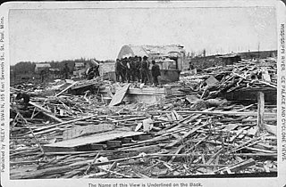
The 1886 Sauk Rapids Tornado was a violent tornado that tore through the cities of Sauk Rapids, St. Cloud, and Rice, Minnesota, on April 14, 1886. It destroyed much of the town of Sauk Rapids and killed 72 people along its path. It is the deadliest tornado on record in Minnesota. Other tornadoes occurred in Iowa, Kansas, Missouri, and Texas on the same day, suggesting the possibility of a large outbreak.