
The Savinja is a river in northeast Slovenia which flows mostly in the Upper and Lower Savinja Valley and through the cities of Celje and Laško. The Savinja is the main river of the Savinja Alps. It flows into the Sava River at the town of Zidani Most. It has often flooded, such as in the 1960s, 1990, and 1995. The Savinja has a length of 101.75 kilometres (63.22 mi) and a catchment area of 1,847.7 km2 (713.4 sq mi).
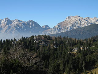
The Kamnik–Savinja Alps are a mountain range of the Southern Limestone Alps. They lie in northern Slovenia, except for the northernmost part, which lies in Austria.

Radeče is a small town in the Lower Sava Valley in eastern Slovenia. It is located in the Sava Hills on the right bank of the Sava River at the confluence with Sopota Creek. It is the seat of the Municipality of Radeče and part of the traditional province of Lower Carniola. The town and the municipality are now included in the Lower Sava Statistical Region; until January 2014 they were part of the Savinja Statistical Region.

Zidani Most is a settlement in the Municipality of Laško in eastern Slovenia. It lies at the confluence of the Sava and Savinja rivers. The area is part of the traditional region of Styria. It is now included with the rest of the municipality in the Savinja Statistical Region. It is an important railway station and junction.

The Tuhinj Valley is a valley in Slovenia linking the Celje Basin with the Ljubljana Basin in an east-west direction along the courses of the Nevljica and Motnišnica rivers.
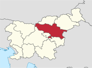
The Savinja Statistical Region is a statistical region in Slovenia. The largest town in the region is Celje. It is named after the Savinja River. The region is very diverse in natural geography; it mainly comprises the wooded mountainous terrain attractive to tourists, the fertile Lower Savinja Valley with good conditions for growing hops, the Kozje Hills, and the Velenje Basin with lignite deposits, used for electricity production. In 2013 the region invested more than EUR 127 million in environmental protection. In 2013, the region accounted for 14% of enterprises created and 8% of enterprises shut down. The region has good natural conditions for agriculture. In 2013 this region had more than 11,000 farms, which is 15% of all farms in Slovenia, ranking the region right behind the Drava Statistical Region. In agricultural area utilised and livestock, the region was also in second place. The region is a well-known and popular tourist destination. In 2012, tourist arrivals and overnight stays in the region represented 11.1% of all tourist arrivals in Slovenia and 15.0% of all overnight stays. On average, tourists spent four nights there.
The Šalek Valley or the Velenje Basin is a basin in northern Slovenia in the northeastern pre-alpine foothills. It is named after Šalek Castle near the town of Velenje. The valley lies between the Kamnik–Savinja Alps to the west, the Pohorje Mountain Range to the east, and the Sava Hills to the south. It has a northwest-southeast orientation and is approximately 8 km long and 2 km wide. It contains a number of rivers and lakes. The Paka River runs through Velenje, with a number of tributaries from the northwest: Trebušnica Creek, Veriželj Creek and Slatina Creek. The Paka itself eventually flows into the Savinja River. The valley is separated from the Upper Savinja Valley and Lower Savinja Valley by the Golte Plateau, the Skorno Hills (Skornški hribi, peaks along the Paka including Mount Oljka, and the Ponikva Plateau.
Buče is a settlement in the Municipality of Kozje in eastern Slovenia. It lies in the Sava Hills northeast of Kozje. The area is part of the historical Styria region. The municipality is now included in the Savinja Statistical Region.
Brdo is a settlement in the Municipality of Šentjur, in eastern Slovenia. It lies in the Sava Hills north of Planina pri Sevnici. The settlement, and the entire municipality, are included in the Savinja Statistical Region, which is in the Slovenian portion of the historical Duchy of Styria.
Hrušovje is a small dispersed settlement in the Sava Hills in the Municipality of Šentjur, in eastern Slovenia. The settlement, and the entire municipality, are included in the Savinja Statistical Region, which is in the Slovenian portion of the historical Duchy of Styria.
Kostrivnica is a dispersed settlement in the Municipality of Šentjur, in eastern Slovenia. It lies in the northern part of the Sava Hills north of Planina. The settlement, and the entire municipality, are included in the Savinja Statistical Region, which is in the Slovenian portion of the historical Duchy of Styria.
Loke pri Planini is a small settlement in the Municipality of Šentjur in eastern Slovenia. It lies in the Sava Hills northeast of Planina pri Sevnici. The settlement, and the entire municipality, are included in the Savinja Statistical Region, which is in the Slovenian portion of the historical Duchy of Styria.
Planinska Vas is a small village in the Municipality of Šentjur, in eastern Slovenia. It lies in the Sava Hills east of Planina pri Sevnici. The settlement, and the entire municipality, are included in the Savinja Statistical Region, which is in the Slovenian portion of the historical Duchy of Styria.
Planinski Vrh is a settlement in the Sava Hills in the Municipality of Šentjur, eastern Slovenia. It lies northeast of Planina pri Sevnici. The settlement, and the entire municipality, are included in the Savinja Statistical Region, which is in the Slovenian portion of the historical Duchy of Styria.
Podvine is a small settlement in the Municipality of Šentjur, eastern Slovenia. It lies in the Sava Hills east of Planina pri Sevnici. The settlement, and the entire municipality, are included in the Savinja Statistical Region, which is in the Slovenian portion of the historical Duchy of Styria.
Straška Gorca is a small settlement in the Municipality of Šentjur in eastern Slovenia. It lies in the Sava Hills, just off the road leading southeast from the town of Šentjur towards Kozje. The settlement, and the entire municipality, are included in the Savinja Statistical Region, which is in the Slovenian portion of the historical Duchy of Styria.

Mala Štanga is a small dispersed settlement in the Municipality of Šmartno pri Litiji in central Slovenia. It lies in the Sava Hills west of Litija. The area is part of the historical region of Lower Carniola. The municipality is now included in the Central Slovenia Statistical Region.

The Styrian dialect group is a group of closely related dialects of Slovene. The Lower Carniolan dialects are spoken in central and eastern Slovenian Styria and in the Lower Sava Valley and Central Sava Valley.
The Central Savinja dialect is a Slovene dialect in the Styrian dialect group. It is spoken in the central Savinja Valley in the basins of the Bolska, Paka, and Hudinja rivers east of the Upper Savinja dialect and west of the Central Styrian dialect, south of the Mežica and South Pohorje dialects, and north of the Eastern Upper Carniolan, Zagorje-Trbovlje, and Laško subdialects. It includes the settlements of Trojane, Špitalič, Vransko, Topolšica, Šoštanj, Velenje, Frankolovo, Vojnik, and Celje.

The Lower Sava Valley dialect is a Slovene dialect spoken in the Central and Lower Sava Valley. It is a transitional dialect between the Lower Carniolan and Styrian dialects. It borders the Lower Carniolan dialect to the west, Upper Carniolan dialect to the northwest, Central Savinja dialect to the north, Central Styrian dialect to the northeast, Kozje-Bizeljsko dialect to the east, and Lower Sutlan Kajkavian dialect to the south, as well as Chakavian and Eastern Herzegovian to the southeast. It is further divided into three subdialects: the northwestern Zagorje-Trbovlje subdialect, northeastern Laško subdialect, and southern Sevnica-Krško subdialect. The dialect belongs to the Styrian dialect group and evolved from Lower Carniolan dialect base.

