
West Haven is a city in New Haven County, Connecticut, United States, and a coastal city of Long Island Sound. At the 2020 census, the population of the city was 54,070.

In the United States, trolley parks, which started in the 19th century, were picnic and recreation areas along or at the ends of streetcar lines in most of the larger cities. These were precursors to amusement parks. Trolley parks were often created by the streetcar companies to give people a reason to use their services on weekends.

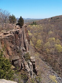
Regicides Trail is a Blue-Blazed hiking trail, about 7 miles (11 km) long, roughly following the edge of a diabase, or traprock, cliff northwest of New Haven, Connecticut. It is named for two regicides, Edward Whalley and his son-in-law William Goffe, who signed the death warrant of King Charles I of England. Upon the restoration of Charles II to the throne and the persecution of the regicides, the pair hid in Judges Cave near the south end of the trail in 1660. The Regicides is widely known to be one of the most technical trails within the CT Blue-Blazed trail system.

Riverside is a neighborhood in the city of East Providence in the U.S. state of Rhode Island. Despite not being an incorporated city, Riverside has its own zip code, 02915, and is an acceptable mailing address according to the United States Postal Service. Riverside has a population of approximately 20,000 people.
Hamilton Park, also known as Brewster Park and Howard Avenue Grounds, was a sports venue in New Haven, Connecticut, located at the intersection of Whalley Avenue and West Park Avenue.
The Mill River is a river in New Haven County, Connecticut.

Cedar Hill is a neighborhood in New Haven, Connecticut. It includes portions of the city-designated neighborhoods of East Rock, Quinnipiac Meadows, and Mill River. Cedar Hill was named for cedar trees that were once plentiful there in 1665. The area was divided from the local surroundings by the construction of I-91 in the 1960s. Cedar Hill's boundary runs from James Street, up the Mill River, to Rice Field, over Indian Head Rock, to the Hamden town line, across to Middletown Avenue, to the Eastern side of State Street, back up to James Street.

The history of West Haven, Connecticut: This article will be covering the colonial and revolutionary history, the economic history, Savin Rock Park, and the 20th century history of West Haven, Connecticut.

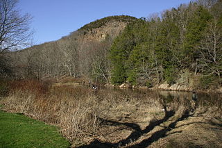
West Rock Ridge State Park is a public recreation area located in New Haven, Hamden, and Woodbridge, Connecticut. The state park is named for the 400-to-700-foot trap rock West Rock Ridge, which is part of the Metacomet Ridge extending from Long Island Sound to the Vermont border. The park's 7 miles (11 km) of open west-facing cliffs offer vistas encompassing Metropolitan New Haven and suburban towns to the west. The park includes Judges Cave, a colonial era historic site; Lake Wintergreen; and the 7-mile (11 km) Regicides Trail, part of the Connecticut Forest and Park Association's Blue Trail system. The park is part of a larger area of protected open space including state, municipal, and non-profit owned land.
The Quinnipiac Trail is a 24-mile (39 km) Blue-Blazed hiking trail in New Haven County, Connecticut. It is the product of the evolution and growth of the first 10.6-mile (17.1 km) trail designated in Connecticut's Blue-Blazed Hiking Trail system, with its light-blue rectangular vertical painted blazes.
Tangletown is an Unincorporated community in Middlesex in Washington County, Vermont, United States, in the central part of the state.

Prospect Hill is a neighborhood of the city of New Haven, Connecticut located in the north central portion of the city, directly north of Downtown New Haven. The neighborhood contains residences, institutional buildings of Albertus Magnus University and a portion of the main campus of Yale University, including the Science Hill area, the Hillhouse Avenue area and the Yale Peabody Museum. The City of New Haven defines the neighborhood to be the region bounded by the town of Hamden in the north, Winchester Avenue in the west, Munson Street/Hillside Place/Prospect Street in the southwest, Trumbull Street in the south, and Whitney Avenue in the east. Prospect Street is the main thoroughfare through the neighborhood.

The Nipmuck Trail is a Blue-Blazed hiking trail "system" which meanders through 34.5 miles (55.5 km) of forests in northeast Connecticut. It is maintained by the Connecticut Forest and Park Association and is considered one of the Blue-Blazed hiking trails. There are two southern trail heads in the south of the town of Mansfield, Connecticut. The southwestern terminus is at a road shoulder parking place on Puddin Lane, and the southeastern terminus is a DEEP parking lot on North Windham Road at the southeast corner of Mansfield Hollow State Park. The northern terminus is at the north end of Breakneck Pond along the Massachusetts border in Nipmuck State Forest. Camping permits may be obtained for up to five separate locations for backpacking.
Electric Park was a name shared by dozens of amusement parks in the United States that were constructed as trolley parks and owned by electric companies and streetcar companies. After 1903, the success of Coney Island inspired a proliferation of parks named Luna Park and Electric Park, while the World's Columbian Exposition of 1893 inspired the formation of White City amusement parks at roughly the same time. The existence of most of these parks was generally brief: the bulk of them closed by 1917, the year of the United States' entry into World War I. Many pavilions have outlasted the parks themselves, with a few of them still standing today.
White City is the common name of dozens of amusement parks in the United States, the United Kingdom, and Australia. Inspired by the White City and Midway Plaisance sections of the World's Columbian Exhibition of 1893, the parks started gaining in popularity in the last few years of the 19th century. After the 1901 Pan-American Exposition inspired the first Luna Park in Coney Island, a frenzy in building amusement parks ensued in the first two decades of the 20th century.

Alppiharju is a district of approximately 12,000 inhabitants in the eastern part of the Central major district of Helsinki, Finland. It consists of sub-districts Alppila and Harju, and is bordered by Kallio in the south, Taka-Töölö in the west, Pasila in the north-west and north, and Vallila in the north-east and east.

The Menunkatuck Trail is an 11.0-mile (17.7 km) Blue-Blazed hiking trail in Guilford, Connecticut and, currently, is almost entirely on protected land owned by the Town of Guilford, the Guilford Conservation Land Trust, the Regional Water Authority (RWA) and on Cockaponset State Forest land.

The Chatfield Trail is a 4.6-mile Blue-Blazed hiking trail located within the town of Killingworth, Connecticut.

Savin Rock was an American amusement park in West Haven, Connecticut. It was previously called The White City and was established in the 1870s. The park included a number of roller coasters, other rides and numerous funhouses.

Thunderbolt was a wooden roller coaster which operated at Savin Rock Amusement Park in West Haven, Connecticut, from 1925 until 1938 when it was destroyed by a hurricane. It was rebuilt in modified form in 1939 and it continued to operate until 1956. When it was first built, it was purported to be the fastest roller coaster in the world.

