Saw Mill Run

Last updated
Saw Mill Run
Tributary to Ohio River
SeldomSeenArch.jpg
The Seldom Seen Arch, built in 1903, over Saw Mill Run along Saw Mill Run Boulevard not far from Woodruff Street in the Beechview neighborhood of Pittsburgh, Pennsylvania
USA Pennsylvania relief location map.svg
Red pog.svg
Location of Saw Mill Run mouth
Usa edcp relief location map.png
Red pog.svg
Saw Mill Run (the United States)
Location
Country United States
State Pennsylvania
County Allegheny County
City Pittsburgh
Borough/Township Castle Shannon
Mt. Lebanon
Physical characteristics
SourceMcLaughlin Run divide
  location Mt. Lebanon, Pennsylvania
  coordinates 40°21′14″N080°02′24″W / 40.35389°N 80.04000°W / 40.35389; -80.04000 [1]
  elevation1,250 ft (380 m) [2]
Mouth Ohio River
  location
Saw Mill Run Boulevard and Carson Street, Pittsburgh, Pennsylvania
  coordinates
40°26′41″N080°01′39″W / 40.44472°N 80.02750°W / 40.44472; -80.02750 Coordinates: 40°26′41″N080°01′39″W / 40.44472°N 80.02750°W / 40.44472; -80.02750 [1]
  elevation
710 ft (220 m) [3]
Length9.12 mi (14.68 km) [4]
Basin size19.42 square miles (50.3 km2) [5]
Discharge 
  location Ohio River
  average19.57 cu ft/s (0.554 m3/s) at mouth with Ohio River [5]
Basin features
Progressionnortheast then northwest [4]
River system Ohio River
Tributaries 
  leftunnamed tributaries
  rightunnamed tributaries
BridgesSanta Fe Drive, Caswell Drive, Milford Drive (x2), Connor Road, Willow Avenue, Canal Street, Castle Shannon Boulevard, Killarney Drive, PA 88, Kingwood Street, PA 51 (x2), Whited Street, PA 51, Fawn Street, Fine Way. PA 51, Edgebrook Avenue, PA 51 (x2), Crane Avenue, I-376, Miniotte Square, Neptune Street, S Main Street, PA 51

Saw Mill Run is a tributary of the Ohio River in Pennsylvania. It is an urban stream, and lies entirely within Allegheny County, Pennsylvania. The stream enters the Ohio just downstream from the Forks of the Ohio in Pittsburgh, at a place that was founded as the town of Temperanceville in the 1830s. It provides an entry through the elevated plateau south of Pittsburgh known as the South Hills, and land transportation has paralleled the stream since the nineteenth century.

Contents

The stream is named for an actual saw mill that operated near the mouth of the stream where it empties into the Ohio River. The first reference to the mill is in relation to the construction of Fort Pitt (1759–1761). The mill provided much of the lumber used in the construction of the new Fort, after the British claimed the area from the French and destroyed Fort Duquesne. [6]

Railroads

The Coal Hill Coal Railroad crossed the stream on a trestle, and extended upstream in 1861. This railroad was purchased by the Pittsburgh and Castle Shannon Railroad, who extended the line to follow the main stream of Saw Mill Run from the Pittsburgh and Castle Shannon Tunnel to Castle Shannon, Pennsylvania. The Little Saw Mill Run Railroad followed the west branch of the stream towards Mt. Lebanon, Pennsylvania. [7]

The Wheeling and Lake Erie Railway (W&LE) operated a short rail line on the western end of the stream, known as the West End Branch. It had been used by the Pittsburgh and West Virginia Railway as a connection with the Pittsburgh and Lake Erie Railroad near West Carson Street. The W&LE operated it until late 2008, [8] [9] and most of the line has been torn up, with the crossing signal cantilevers on Steuben Street being removed in 2012.[ citation needed ]

Trolley and light rail

The right of way of the Pittsburgh and Castle Shannon, excluding the Pittsburgh and Castle Shannon Tunnel through a coal mine, was leased by Pittsburgh Railways in 1905, and later purchased in 1950. The railroad ran with a dual gauge system, with coal trains continuing to run on the narrow gauge, and at night, and trolleys on a wider gauge. The right of way is part of the Pittsburgh Light Rail transportation system today, which follows the stream from near the South Hills Junction (PAT station) to Castle Shannon, Pennsylvania.

Highways

Part of Pennsylvania Route 51 runs parallel to the stream, and this section is known as Saw Mill Run Boulevard.

Watershed

The watershed of Saw Mill Run covers 12,432 acres (50.31 km2), or about 19 square miles (49 km2). The main stream is 9.3 miles (15.0 km) long, and drains parts of Bethel Park, Castle Shannon, Mount Oliver, and the city of Pittsburgh. [10]

See also

Related Research Articles

<span class="mw-page-title-main">Bear Run</span> Stream in Pennsylvania, USA

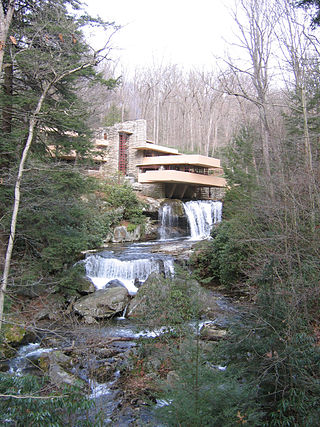
Bear Run is a 5.0-mile-long (8.0 km) tributary of the Youghiogheny River in Fayette County, Pennsylvania, in the United States.

<span class="mw-page-title-main">Larrys Creek</span> Tributary of the West Branch Susquehanna River

Larrys Creek is a 22.9-mile-long (36.9 km) tributary of the West Branch Susquehanna River in Lycoming County in the U.S. state of Pennsylvania. A part of the Chesapeake Bay drainage basin, its watershed drains 89.1 square miles (231 km2) in six townships and a borough. The creek flows south from the dissected Allegheny Plateau to the Ridge-and-valley Appalachians through sandstone, limestone, and shale from the Devonian, Mississippian, and Pennsylvanian periods.

<span class="mw-page-title-main">Anderson Creek (Pennsylvania)</span> Stream in Pennsylvania, USA

Anderson Creek is a 23.6-mile-long (38.0 km) tributary of the West Branch Susquehanna River in Clearfield County, Pennsylvania, in the United States.

<span class="mw-page-title-main">Casselman River</span> Stream in Pennsylvania, USA

The Casselman River is a 56.5-mile-long (90.9 km) tributary of the Youghiogheny River in western Maryland and Pennsylvania in the United States. The Casselman River drains an area of 576 square miles.

<span class="mw-page-title-main">Chartiers Creek</span> Stream in Pennsylvania, USA

Chartiers Creek is a tributary of the Ohio River in Western Pennsylvania in the United States. The creek was named after Peter Chartier, a trapper of French and Native American parentage who established a trading post at the mouth of the creek in 1743.

<span class="mw-page-title-main">Jacobs Creek (Youghiogheny River tributary)</span> River in southwestern Pennsylvania, United States

Jacobs Creek is a 33.4-mile-long (53.8 km) tributary of the Youghiogheny River beginning in Acme, Pennsylvania and draining at its mouth in the town of Jacobs Creek into the Youghiogheny River. Jacobs Creek is the southwestern border of Westmoreland County and the northwestern border of Fayette County. The area was a major producer of rye whiskey in the decades before Prohibition.

The Little Saw Mill Run Railroad was a 4 ft 8+12 instandard gauge coal railroad in Allegheny County, Pennsylvania. It was incorporated July 23, 1850, and opened in April 1853. Originally, it was owned by the Harmony Society, and ran from Temperanceville, Pennsylvania on the Ohio River to Banksville, Pennsylvania, running parallel to Saw Mill Run and Little Saw Mill Run. In an agreement with the 3 ft narrow gauge Pittsburgh Southern Railroad, it ran dual gauge tracks. It became part of the railroad empire of George J. Gould, merging with the West Side Belt Railroad in 1897. The superintendent of the Marine Railway at Sawmill Run for 13 years was Captain Edward Boland.

Streets Run is a 5.2-mile-long (8.4 km) tributary of the Monongahela River in Allegheny County, Pennsylvania. This urban stream drains portions of the communities of Pittsburgh, Baldwin, Brentwood, West Mifflin and Whitehall, an area of about ten square miles.

<span class="mw-page-title-main">Buffalo Creek (Ohio River tributary)</span> Tributary of the Ohio River

Buffalo Creek is a stream in the U.S. states of Pennsylvania and West Virginia. It rises in East Finley Township, Washington County, Pennsylvania. Its tributaries are Brushy Run, Mill Run, Indian Camp Run, Buck Run, and Dutch Fork. These streams flow through the townships of East Findley, Donegal, Hopewell, and Buffalo, and the creek itself empties into the Ohio River at Wellsburg, West Virginia. The stream was presumably named for a Buffalo trace that once passed through the valley.

<span class="mw-page-title-main">South Branch French Creek (French Creek tributary)</span> Stream in Pennsylvania, USA

South Branch French Creek is a 24.2-mile (38.9 km) long tributary to French Creek in Erie County, Pennsylvania. It is classed as a 3rd order stream on the EPA waters geoviewer site.

<span class="mw-page-title-main">Quebec Run</span> Stream in Pennsylvania, USA

Quebec Run is a 3.74 mi (6.02 km) long 3rd order tributary to Big Sandy Creek in Fayette County, Pennsylvania. This is the only stream of this name in the United States.

Tebolt Run is a 3.46 mi (5.57 km) long 2nd order tributary to Big Sandy Creek in Fayette County, Pennsylvania. This is the only stream of this name in the United States.

Little Conneauttee Creek is a 14.27 mi (22.97 km) long 3rd order tributary to Conneauttee Creek in Crawford County, Pennsylvania and Erie County, Pennsylvania. This is the only stream of this name in the United States.

Darrows Creek is a 4.80 mi (7.72 km) long 3rd order tributary to Conneauttee Creek in Erie County, Pennsylvania. This is the only stream of this name in the United States.

Torry Run is a 5.83 mi (9.38 km) long 2nd order tributary to Conneauttee Creek in Crawford County, Pennsylvania and Erie County, Pennsylvania. This is the only stream of this name in the United States.

West Branch Cussewago Creek is a 5.55 mi (8.93 km) long 2nd order tributary to Cussewago Creek in Crawford and Erie Counties, Pennsylvania. This is the only stream of this name in the United States.

Castleman Run is a 7.54 mi (12.13 km) long 3rd order tributary to Buffalo Creek in Brooke County, West Virginia. This is the only stream of this name in the United States. Castleman Run Lake, an impoundment of this stream, is protected as Castleman Run Lake Wildlife Management Area by the State of West Virginia.

Laidley Run is a 3.16 mi (5.09 km) long 2nd order tributary to Middle Wheeling Creek in Ohio County, West Virginia. This is the only stream of this name in the United States.

Kratzer Run is a 5.75 mi (9.25 km) long 3rd order tributary to Anderson Creek in Clearfield County, Pennsylvania. This is the only stream of this name in the United States. Kratzer Run is the largest tributary to Anderson Creek and drains a region of farmland and places that have been surface mined for coal. As a result, Kratzer Run suffers from Acid Mine Drainage (AMD) and the impact of adjacent highways and communities is considered the most degraded tributary to Anderson Creek. Bilger Run, a tributary, is also impaired by AMD. Numerous places of erosion have been noted as well. In spite of the impacts, numerous efforts are underway to mitigate the pollution.

<span class="mw-page-title-main">Bilger Run</span> Stream in Pennsylvania, USA

Bilger Run is a 5.05 mi (8.13 km) long 2nd order tributary to Kratzer Run in Clearfield County, Pennsylvania and Kratzer Run's largest and only named tributary. Its watershed accounts for nearly half of the greater Kratzer Run watershed. This is the only stream of this name in the United States. Bilger Run has an ID number of 1169617 from the US Board of Geographic Names.

References

  1. 1 2 "GNIS Detail - Sawmill Run". geonames.usgs.gov. US Geological Survey. Retrieved 12 May 2021.
  2. "Get Maps". USGS Topoview. US Geological Survey. Retrieved 12 May 2021.
  3. "Get Maps". USGS Topoview. US Geological Survey. Retrieved 12 May 2021.
  4. 1 2 "ArcGIS Web Application". epa.maps.arcgis.com. US EPA. Retrieved 12 May 2021.
  5. 1 2 "Sawmill Run Watershed Report". US EPA Geoviewer. US EPA. Retrieved 12 May 2021.
  6. Lorant, Stefan (1999). Pittsburgh: The story of an American city (5th ed.). Esselmont Books. ISBN   0967410304. OCLC   42704989.
  7. Pennsylvania, Geological Survey of (1887). Annual Report of the Geologic Survey of Pennsylvania for 1885-1887. p. 161.
  8. Schmitz, Jon (13 June 2011). "West End Circle traffic still dealing with a snag". Pittsburgh Post-Gazette. Archived from the original on 10 December 2015.
  9. Schmitz, Jon (11 January 2012). "West End railroad underpass that snarled traffic to come down". Pittsburgh Post-Gazette.
  10. "AMD and Sediment MDLs for Sawmill Run" (PDF). Retrieved 2009-05-24.[ dead link ]