
Marienheide is a municipality in the Oberbergischer Kreis, in North Rhine-Westphalia, Germany.
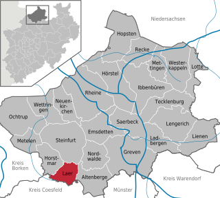
Laer is a municipality in the district of Steinfurt, in North Rhine-Westphalia, Germany. It is situated approximately 10 kilometres (6.2 mi) south of Steinfurt and 20 kilometres (12 mi) north-west of Münster.
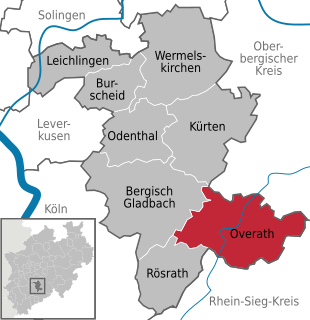
Overath is a town in the Rheinisch-Bergischer district, in North Rhine-Westphalia, Germany.

Alpen is a municipality in the district of Wesel, North Rhine-Westphalia, Germany.

Wachtendonk at the confluence of Niers River and Nette River is a municipality in the district of Kleve in North Rhine-Westphalia, Germany. It is located west of the Rhine half way between Duisburg and Venlo at the Dutch border. Its name means 'bailiff's Donk'.

Dorsten is a town in the district of Recklinghausen in North Rhine-Westphalia, Germany and has a population of about 75,000.

Selfkant is a municipality in the Heinsberg district, in North Rhine-Westphalia, Germany. It is the most westerly municipality in Germany since 1919; until then, the title had been held by Gravelotte, in Alsace-Lorraine. Selfkant's border with the Netherlands is 27 km long, but the border with the rest of Germany is only 6 km long.
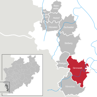
Simmerath is a municipality in the district of Aachen, in North Rhine-Westphalia, Germany. It is located approximately 20 km south-east of Aachen, near the border to Belgium.

Schöppingen is a municipality in the district of Borken in the state of North Rhine-Westphalia, Germany. It is located approximately 10 km south-west of Steinfurt.

Rees is a town in the district of Kleve in the state of North Rhine-Westphalia, Germany. It is located on the right bank of the Rhine, approximately 20 km east of Kleve. The population in 2005 was 22,559. Founded in 1228, Rees is the oldest town in the lower Rhine area.

Rheda-Wiedenbrück is a city in the district of Gütersloh, in North Rhine-Westphalia, Germany.

Steinheim is a town in Höxter district in North Rhine-Westphalia, Germany.
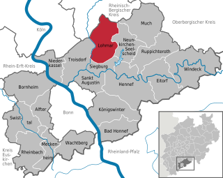
Lohmar is a town in the Rhein-Sieg district, in North Rhine-Westphalia, Germany.

Sankt Augustin is a town in the Rhein-Sieg district, in North Rhine-Westphalia, Germany. It is named after the patron saint of the Divine Word Missionaries, Saint Augustine of Hippo (354-430). The Missionaries established a monastery near the current town centre in 1913. The municipality of Sankt Augustin was established in 1969, and on September 6, 1977 Sankt Augustin acquired town privileges. Sankt Augustin is situated about eight km north-east of Bonn and three km south-west of Siegburg.

Hörstel (help·info) is a town in the district of Steinfurt, in North Rhine-Westphalia, Germany. It is situated near the junction of the Mittellandkanal and the Dortmund-Ems Canal, approx. 10 km east of Rheine.

Hamminkeln is a town in the district of Wesel, in North Rhine-Westphalia, Germany. It is situated on the river Issel, approximately 10 kilometers north of Wesel and 15 km south of Bocholt. It is twinned with Sedgefield, United Kingdom and the largest town in the district of Wesel.

Rheinberg is a town in the district of Wesel, in North Rhine-Westphalia, Germany. It is situated on the left bank of the Rhine, approx. 10 kilometres north of Moers and 15 km south of Wesel.

Hünxe is a municipality in the district of Wesel, in North Rhine-Westphalia, Germany. It is part of the Rhine-Waal euroregion

Sonsbeck is a municipality in the district of Wesel, in North Rhine-Westphalia, Germany. It is situated approximately 20 km west of Wesel, and 25 km south-east of Cleves as well as 8 km from the historic city of Xanten.
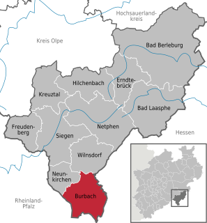
Burbach is a municipality in the Siegen-Wittgenstein district, in North Rhine-Westphalia, Germany.


