Alpen, Germany

Last updated
Alpen
Alpen, Rathaus, 2017-08 CN-01.jpg
Town hall
Wappen der Gemeinde Alpen.svg
Location of Alpen within Wesel district
Alpen in WES.svgAlpen
Germany adm location map.svg
Red pog.svg
Alpen
North Rhine-Westphalia location map 01.svg
Red pog.svg
Alpen
Coordinates: 51°34′30″N06°30′45″E / 51.57500°N 6.51250°E / 51.57500; 6.51250 Coordinates: 51°34′30″N06°30′45″E / 51.57500°N 6.51250°E / 51.57500; 6.51250
Country Germany
State North Rhine-Westphalia
Admin. region Düsseldorf
District Wesel
Subdivisions4
Government
   Mayor (202025) Thomas Ahls [1] (CDU)
Area
  Total59.54 km2 (22.99 sq mi)
Elevation
25 m (82 ft)
Population
 (2021-12-31) [2]
  Total12,528
  Density210/km2 (540/sq mi)
Time zone UTC+01:00 (CET)
  Summer (DST) UTC+02:00 (CEST)
Postal codes
46519
Dialling codes 02802
Vehicle registration WES
Website www.alpen.de

Alpen is a municipality in the district of Wesel, North Rhine-Westphalia, Germany.

Contents

Geography

Alpen is situated in the Lower Rhine region, located between the Ruhr area and the border with the Netherlands. Adjacent cities are Rheinberg, Xanten.

Division of the town

The municipality consists of 4 districts:

History

Alpen was mentioned documentarily for the first time in 1074.

Politics

The local Municipal Council is represented by the Christian Democratic Union, Social Democratic Party of Germany, Alliance '90/The Greens and the Free Democratic Party.

Transportation

Alpen is reachable by the Bundesautobahn 57 and the federal highways B57 and B58. There is also a train, the RB31 from Duisburg Hbf (direction Xanten) every hour which stops at Alpen. From there it is a 10-minute walk into the centre of Alpen.

Security

The municipality of Alpen maintains a Volunteer Fire Department consisting three firehouses with about 105 active firefighter and 14 vehicles. In addition to the area of Alpen, the Bundesautobahn 57 is also part of the area of operation. Crime protection is provided by the state Police of North Rhine-Westphalia with stations in Rheinberg, Xanten and Kamp-Lintfort.

Related Research Articles

<span class="mw-page-title-main">Oelde</span> Town in North Rhine-Westphalia, Germany

Oelde is a town in the district of Warendorf, in North Rhine-Westphalia, Germany. It is located near Beckum.

<span class="mw-page-title-main">North Rhine-Westphalia</span> State in Germany

North Rhine-Westphalia, commonly shortened to NRW, is a state (Land) in Western Germany. With more than 18 million inhabitants, it is the most populous state of Germany. Apart from the city-states, it is also the most densely populated state in Germany. Covering an area of 34,084 square kilometres (13,160 sq mi), it is the fourth-largest German state by size.

<span class="mw-page-title-main">Dinslaken</span> Town in North Rhine-Westphalia, Germany

Dinslaken is a town in the district of Wesel, in North Rhine-Westphalia, Germany. It is known for its harness racing track, its now closed coal mine in Lohberg and its wealthy neighborhoods Hiesfeld and Eppinghoven.

<span class="mw-page-title-main">Augustdorf</span> Town in North Rhine-Westphalia, Germany

Augustdorf is a municipality in the Lippe district of North Rhine-Westphalia, Germany. It has an area of 42.18 km² and about 10,100 inhabitants (2020).

<span class="mw-page-title-main">Ruppichteroth</span> Town in North Rhine-Westphalia, Germany

Ruppichteroth is a municipality in the Rhein-Sieg district, in the southern part of North Rhine-Westphalia, Germany. It is located approximately 30 kilometers east of Bonn.

<span class="mw-page-title-main">Kaarst</span> Town in North Rhine-Westphalia, Germany

Kaarst is a town in Germany. It lies in the district of Rhein-Kreis Neuss in North Rhine-Westphalia. It is 5 km west of Neuss and 12 km east of Mönchengladbach.

<span class="mw-page-title-main">Meerbusch</span> Town in North Rhine-Westphalia, Germany

Meerbusch is a town in Rhein-Kreis Neuss, North Rhine-Westphalia, Germany. It has been an incorporated town since 1970. Meerbusch is the municipality with the most income millionaires in North Rhine-Westphalia.

<span class="mw-page-title-main">Nottuln</span> Municipality in North Rhine-Westphalia, Germany

Nottuln is a municipality in the district of Coesfeld in the state of North Rhine-Westphalia, Germany.

<span class="mw-page-title-main">Uedem</span> Municipality in North Rhine-Westphalia, Germany

Uedem is a municipality in the district of Cleves, in North Rhine-Westphalia, Germany. It is located near the border with the Netherlands.

<span class="mw-page-title-main">Südlohn</span> Municipality in North Rhine-Westphalia, Germany

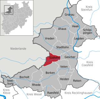
Südlohn is a municipality in the district of Borken in the northwestern part of North Rhine-Westphalia, Germany. It is located right at the border with the Netherlands, approx. 10 km east of Winterswijk. It consists of the villages Südlohn and Oeding.

<span class="mw-page-title-main">Titz</span> Municipality in North Rhine-Westphalia, Germany

Titz is a municipality in the district of Düren in the state of North Rhine-Westphalia, Germany. It is located approximately 10 kilometres (6.2 mi) north-east of Jülich and 20 kilometres (12 mi) south of Mönchengladbach.

<span class="mw-page-title-main">Waldfeucht</span> Municipality in North Rhine-Westphalia, Germany

Waldfeucht is a German municipality in the Heinsberg district, in North Rhine-Westphalia, Federal Republic of Germany. It is situated on the border with the Kingdom of the Netherlands, approx. 15 km south of Roermond and 8 km west of Heinsberg.

<span class="mw-page-title-main">Stemwede</span> Town in North Rhine-Westphalia, Germany

Stemwede is a municipality in the Minden-Lübbecke district, in North Rhine-Westphalia, Germany. Following a recent regional reorganization, in 1973, the former districts of Dielingen-Wehdem and Levern were consolidated and the district of "Stemwede" created. The new name was chosen because for a thousand years the area along the Stemweder Berg (mountain) was popularly referred to as Stemwede.

<span class="mw-page-title-main">Lohmar</span> Town in North Rhine-Westphalia, Germany

Lohmar is a town in the Rhein-Sieg district, in North Rhine-Westphalia, Germany.

<span class="mw-page-title-main">Alfter</span> Municipality in North Rhine-Westphalia, Germany

Alfter is a municipality in the Rhein-Sieg district, in North Rhine-Westphalia, Germany. It is situated approximately 6 km west of Bonn.

<span class="mw-page-title-main">Lotte, Germany</span> Town in North Rhine-Westphalia, Germany

Lotte is a municipality in the district of Steinfurt, in North Rhine-Westphalia, Germany.

<span class="mw-page-title-main">Nordwalde</span> Town in North Rhine-Westphalia, Germany

Nordwalde is a municipality in the district of Steinfurt, in North Rhine-Westphalia, Germany.

<span class="mw-page-title-main">Ostbevern</span> Municipality in North Rhine-Westphalia, Germany

Ostbevern is a municipality in the district of Warendorf, in North Rhine-Westphalia, Germany.

<span class="mw-page-title-main">Sonsbeck</span> Municipality in North Rhine-Westphalia, Germany

Sonsbeck is a municipality in the district of Wesel, in North Rhine-Westphalia, Germany. It is situated approximately 20 km west of Wesel, and 25 km south-east of Cleves as well as 8 km from the historic city of Xanten.

<span class="mw-page-title-main">Burbach, North Rhine-Westphalia</span> Municipality in North Rhine-Westphalia, Germany

Burbach is a municipality in the Siegen-Wittgenstein district, in North Rhine-Westphalia, Germany.

References

  1. Wahlergebnisse in NRW Kommunalwahlen 2020, Land Nordrhein-Westfalen, accessed 30 June 2021.
  2. "Bevölkerung der Gemeinden Nordrhein-Westfalens am 31. Dezember 2021" (in German). Landesbetrieb Information und Technik NRW . Retrieved 20 June 2022.