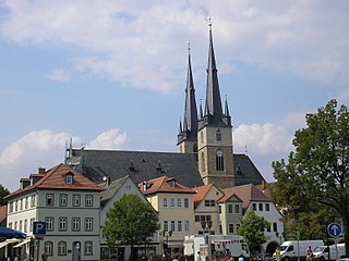
Saalfeld is a town in Germany, capital of the Saalfeld-Rudolstadt district of Thuringia. It is best known internationally as the ancestral seat of the Saxe-Coburg and Gotha branch of the Saxon House of Wettin.

Blankenstein is a village and a former municipality in the district Saale-Orla-Kreis, in Thuringia, Germany. On 1 January 2019 it became part of the new municipality Rosenthal am Rennsteig. Prior to 2019, Blankenstein had been the seat of the Saale-Rennsteig Verwaltungsgemeinschaft, which was disbanded in the reorganisation.

Gräfenthal is a town in the district of Saalfeld-Rudolstadt in Thuringia, Germany.

Schmiedefeld am Rennsteig is a village and a former municipality in Thuringia, Germany. Formerly in the district Ilm-Kreis, it is part of the town Suhl since January 2019.
Rennsteig is a former Verwaltungsgemeinschaft in the district Ilm-Kreis, in Thuringia, Germany. The seat of the Verwaltungsgemeinschaft was in Schmiedefeld am Rennsteig. It was disbanded in January 2019.

Lichte is a village and a former municipality in the district of Sonneberg in Thuringia, Germany, close to the Thuringian Rennsteig. Formerly in the district Saalfeld-Rudolstadt, it is part of the town Neuhaus am Rennweg since January 2019.
Piesau is a village and a former municipality in the district of Sonneberg in Thuringia, Germany, close to the Thuringian Rennsteig. Formerly in the district Saalfeld-Rudolstadt, it is part of the town Neuhaus am Rennweg since January 2019.
Reichmannsdorf is a village and a former municipality in the district Saalfeld-Rudolstadt, in Thuringia, Germany. Since 1 January 2019, it is part of the town Saalfeld. Before, it belonged to the municipal association Lichtetal am Rennsteig, which consisted of the municipalities Lichte, Piesau, Reichmannsdorf, and Schmiedefeld.
Lichtetal am Rennsteig is a former municipal association in the district of Saalfeld-Rudolstadt, in Thuringia, Germany. The seat of government was in Lichte. It was disbanded in January 2019.

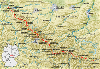
The Rennsteig is a ridge walk as well as a historical boundary path in the Thuringian Forest, Thuringian Highland and Franconian Forest in Central Germany. The long-distance trail runs for about 170 km from Eisenach and the Werra valley in the northwest to Blankenstein and the Selbitz river in the southeast.
The Mittelberg is an 803.6 m high mountain located in the Thuringian Highland, Thuringia (Germany).
The Apelsberg is a 785.3 m high mountain located in the Thuringian Highland, Thuringia (Germany).
In the Free state of Thuringia there is the possibility to establish municipal associations (de:Verwaltungsgemeinschaften) according to § 46 of the Thuringian Communal- and District Order . In addition, the transference of administration procedures to a particular fulfilling municipality might be possible as well.
The Rückersbiel a 755.6 m high mountain located in the Thuringian Highland, Thuringia (Germany).

The Rauhhügel is an 812.9 m high mountain located in the Thuringian Highland, Thuringia, Germany.
The Aßberg is a 703-m high mountain located in the Thuringian Highland region of Thuringia, Germany.

The Lichte (Thuringia) station German: Bahnhof Lichte (Thüringen) was a Deutsche Reichsbahn station in the Thuringian municipality of Lichte in the district of Saalfeld-Rudolstadt. The station is elevated 623 m above Sea Level.

The Lichte (Thuringia) east station was a Deutsche Reichsbahn station of the Thuringian municipality of Lichte (Wallendorf) in the district of Saalfeld-Rudolstadt.
Schmiedefeld is the name of the following populated places:
Wallendorf is an Ortsteil (subdivision) of the Lichte municipality. It is located in the district of Saalfeld-Rudolstadt in Thuringia, Germany, close to the Thuringian Rennsteig.


