
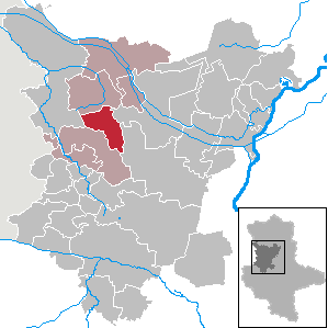
Barleben is a municipality in the Börde district in Saxony-Anhalt, Germany. It is situated approximately 8 km north of Magdeburg.

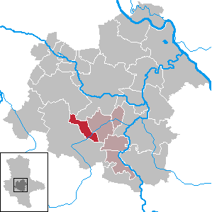
Kabelsketal is a municipality in the Saalekreis district, in Saxony-Anhalt, Germany. It is situated east of Halle (Saale). It was formed in 2004 out of the villages of Dieskau, Dölbau, Gröbers und Großkugel.
Anhalt-Bitterfeld is a district in Saxony-Anhalt, Germany. Its capital is Köthen (Anhalt). Its area is 1,455.1 km2 (561.8 sq mi).
Saalekreis is a district in Saxony-Anhalt, Germany. The district seat is Merseburg. Its area is 1,434.2 km2 (553.7 sq mi). It is bounded by the districts Kyffhäuserkreis (Thuringia), Mansfeld-Südharz, Salzlandkreis, Anhalt-Bitterfeld, Nordsachsen, Leipzig and Burgenlandkreis. The district-free city of Halle is surrounded by the Saalekreis.
Harz is a district in Saxony-Anhalt, Germany. Its area is 2,104.9 km2 (812.7 sq mi).
Mansfeld-Südharz is a district in Saxony-Anhalt, Germany. Its area is 1,449.1 km2 (559.5 sq mi).

Bitterfeld-Wolfen is a town in the district Anhalt-Bitterfeld, Saxony-Anhalt, Germany. It is situated in south-eastern Saxony-Anhalt, west of the river Mulde, in an area that is dominated by heavy industry and lignite mining. The town was formed by merger of the towns Bitterfeld and Wolfen and the municipalities Greppin, Holzweißig and Thalheim on 1 July 2007.

Ummendorf is a municipality in the Börde district in Saxony-Anhalt, Germany.
Altenhausen is a municipality in the Börde district in Saxony-Anhalt, Germany. On 1 January 2010 it absorbed the former municipalities Emden and Ivenrode.

Ausleben is a municipality in the Börde district in Saxony-Anhalt, Germany.

Eilsleben is a municipality in the Börde district in Saxony-Anhalt, Germany. In January 2010 it absorbed the former municipality Wormsdorf and in September 2010 the former municipalities Drackenstedt, Druxberge and Ovelgünne.

Harbke is a municipality in the Börde district in Saxony-Anhalt, Germany.

Rogätz is a municipality in the Börde district in Saxony-Anhalt, Germany. It is located on the left bank of the river Elbe, and is linked to Schartau by the Rogätz Ferry.

Völpke is a municipality in the Börde district in Saxony-Anhalt, Germany. Völpke has a population of 1,230.

Gleina is a municipality in the Burgenlandkreis district, in Saxony-Anhalt, Germany. Since 2009 it has included Baumersroda and Ebersroda.

Teutschenthal is a municipality in the Saalekreis district, Saxony-Anhalt, Germany. In January 2005 it absorbed the former municipalities Holleben and Zscherben, in January 2010 Dornstedt, Langenbogen and Steuden and in September 2010 Angersdorf.
Giersleben is a municipality in the district of Salzlandkreis, in Saxony-Anhalt, Germany.

Kamern is a municipality in the district of Stendal, in Saxony-Anhalt, Germany. In January 2010 it absorbed the former municipalities Schönfeld and Wulkau.

Kaiserpfalz is a municipality in the Burgenlandkreis district, in Saxony-Anhalt, Germany. It was formed by the merger of the previously independent municipalities Bucha, Memleben and Wohlmirstedt, on 1 July 2009.

Gutenborn is a municipality in the Burgenlandkreis district, in Saxony-Anhalt, Germany. It was formed on 1 January 2010 by the merger of the former municipalities Bergisdorf, Droßdorf, Heuckewalde and Schellbach.


