Related Research Articles
Gilesgate is a suburb of Durham in County Durham, England. It had a population at the 2011 census of 8,074.

Roose or Roosecote is a suburb and former ward of Barrow-in-Furness, Cumbria, England. The word 'roose' is Celtic for "moor" or "heath" and the suffix 'cote' of Roosecote means "hut" or "huts". Before the building of Roose Cottages and the arrival of the Cornish miners Roose was pronounced with a hard S, as in goose; now it is locally pronounced 'Rooze', due to the Cornish accent. Roose is served by Roose railway station, one of the few remaining stations on the Furness Line in the Barrow area.

Barrow Island is an area and former electoral ward of Westmorland and Furness, Cumbria, England. Originally separate from the British mainland, land reclamation in the 1860s saw the northern fringes of the island connected to Central Barrow. Barrow Island is also bound to the south and east by the town's dock system and to the west by Walney Channel. The Ward population taken at the 2011 census was 2,616.

Great Junction Street is a street in Leith, on the northern outskirts of Edinburgh, Scotland. It runs southeast to northwest following approximately the southwestmost line of the old town walls around Leith.

Leith Walk is one of the longest streets in Edinburgh, Scotland, and is the main road connecting the east end of the city centre to Leith.

Boland's Mill is located on the Grand Canal Dock in Dublin, Ireland on Ringsend Road between the inner basin of Grand Canal Dock and Barrow Street. The site, originally associated with Boland's Bakery, includes a number of 19th century warehouses. As of 2019, it was undergoing a €150 million reconstruction to become Bolands Quay, a development of new residences and commercial, retail, and civic spaces. By July 2024, the development was due to be opened on a "phased basis between late 2024 and early 2025".
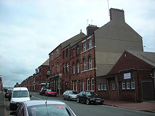
Hindpool is an area and electoral ward of Barrow-in-Furness, Cumbria, England. It is bordered by Barrow Island, Central Barrow, Ormsgill, Parkside and the Walney Channel, the local population stood at 5,851 in 2011. The ward covers the entire western half of the town centre and includes Barrow's main shopping district. Other local landmarks include the Furness College Channelside campus, the Dock Museum and the Main Public Library. Hindpool is also home to two stadia - Barrow Raiders' Craven Park and Barrow A.F.C.'s Holker Street.

Abbey Road is the principal north to south arterial road through Barrow-in-Furness, Cumbria, England.
Furness Academy is a secondary school in Barrow-in-Furness, England. It is the fourth academy to have been formed in the county of Cumbria after the closure of Alfred Barrow School, Parkview Community College of Technology and Thorncliffe School in 2009. Having utilised numerous buildings of the former Parkview and Thorncliffe Schools since 2009, a single £22 million building opened in the Parkside area of the town in September 2013.

The Hindpool Retail Parks are a set of four conjoined retail parks in the Hindpool area of Barrow-in-Furness, England, United Kingdom. Some thirty stores and leisure facilities contain a total of 43,000 m2 (460,000 sq ft) of retail space. The four retail parks are Cornerhouse Retail Park, Cornmill Crossing, Hindpool Retail Park and Hollywood Park. The largest and only other retail park in Barrow is Walney Road Retail Park - Asda, Argos, Home Bargains, Matalan, Starbucks and Stollers.
Barrow Park is a 45-acre public park in Barrow-in-Furness, Cumbria, England. It is located entirely within the Parkside ward, to which the park lends its name, bound by Abbey Road, Park Drive, Greengate Street and Park Avenue. Barrow Park was designed by Thomas Mawson in 1908 and was constructed in stages over the following two decades. Originally sited on the outskirts of Barrow, the park is now more or less central due to rapid growth of the town northwards during the early 20th century. It is designated by Historic England as Grade II on the Register of Historic Parks and Gardens.

St Mary of Furness is a Roman Catholic church located on Duke Street in Barrow-in-Furness, England. The congregation was founded in 1858 and current building constructed between 1866 and 1867.

The Iron County MRA is a Multiple Resource Area addition to the National Register of Historic Places, which includes 72 separate structures and historic districts within Iron County, Michigan, United States of America. These properties were identified and placed on the Register in 1983, with the exception of one property that was placed on the Register in 1993.
Longlands is a historic district within Bradford City Centre, West Yorkshire, England. It lies on the north west edge of the City Centre with boundaries roughly the equivalent of Sunbridge Road to the west, Grattan Road to the south, Westgate to the east and City Road to the north. The district is often mistakenly referred to as the "Chain Street Estate" after one of the local residential streets or falsely amalgamated with the adjacent Goitside district which lies further down the hill towards the Bradford Beck.

The John Whinnerah Institute is a Grade II listed Art Deco building and former educational establishment located on Abbey Road in Barrow-in-Furness, England. Having been constructed between 1937 and 1938 on the site of the demolished Jute Works it is the newest listed structure in the town, despite this it was drastically altered in 2004 when the entire interior was demolished to accommodate new retail units leaving only the Abbey Road and Hindpool Road facades.

The Devonshire Buildings are two adjacent apartment buildings in the Barrow Island area of Barrow-in-Furness, Cumbria, England. They are both recorded in the National Heritage List for England as designated Grade II* listed buildings.
St. George's Square, in Barrow-in-Furness, Cumbria, England is a public space that acted as the centre of the town during the late 19th century. The square now lies in the southernmost fringes of the Central ward close to the Port of Barrow.

Ramsden Square is a square located at the intersection of Abbey Road and Duke Street in Barrow-in-Furness, Cumbria, England. It marks the boundary of the Central and Hindpool wards and now acts as a major roundabout. Ramsden Square was first laid out in the 1840s to act as a focal point of Sir James Ramsden's master plan for the new town of Barrow, separating its burgeoning industries and commercial core. The centerpiece of the square is a statue of Ramsden himself while it is framed by a number of historic buildings including Barrow Central Library, the National Westminster Bank Building and formerly the Barrow Jute Works.
Schneider Square is a square located at the intersection of Duke Street, Dalton Road, Michaelson Road, Burlington Street and Fisher's Yard in Barrow-in-Furness, Cumbria, England. Schneider Square has changed little since its construction in the mid-19th century and now lies within a conservation area. Named after Henry Schneider who played a major role in the development of Barrow, there is a statue commemorating the industrialist in the centre of the square. Located on, or immediately adjacent to Schneider Square are Barrow Town Hall, Craven House, former Barrow Higher Grade School, Hotel Majestic, Burlington House and Duke Street Surgery.
The Dumas Tenements are a pair of four-unit apartment buildings, set back-to-back at 114 West Allen and 114 West Canal Streets in Winooski, Vermont. Built about 1907 by a French Canadian immigrant, they are among the only buildings of their type to survive the city's urban redevelopment efforts of the late 20th century. They were listed on the National Register of Historic Places in 2012.
References
- 1 2 Culture, Conflict, and Migration: The Irish in Victorian Cumbria . Liverpool University Press. 1998. p. 53 . Retrieved 13 December 2015.
scotch buildings barrow.
- ↑ "Historic Buildings Report: Egerton Buildings, Ramsden Dock Road" (PDF). Historic England. 2008. Retrieved 13 December 2015.