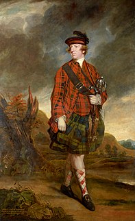
John Murray, 4th Earl of Dunmore, known as Lord Dunmore, was a Scottish peer and colonial governor in the American colonies and The Bahamas. He was the last colonial governor of Virginia.

Colonial National Historical Park is located in the Hampton Roads region of Virginia and is operated by the National Park Service of the United States government. The park protects and interprets several sites relating to the Colony of Virginia and the history of the United States more broadly, ranging from the site of the first landing of the English settlers who would settle at Jamestown, to the battlefields of Yorktown where the British Army was finally defeated in the American Revolutionary War. Over 3 million people visit the park each year.
Hermitage, The Hermitage or L'Hermitage may refer to:

The Pocomoke River stretches approximately 66 miles (106 km) from southern Delaware through southeastern Maryland in the United States. At its mouth, the river is essentially an arm of Chesapeake Bay, whereas the upper river flows through a series of relatively inaccessible wetlands called the Great Cypress Swamp, largely populated by Loblolly Pine, Red Maple and Bald Cypress. The river is the easternmost river that flows into Chesapeake Bay. "Pocomoke", though traditionally interpreted as "dark water" by local residents, is now agreed by scholars of the Algonquian languages to be derived from the words for "broken ground."

Joint Expeditionary Base–Little Creek (JEB–LC), formerly known as Naval Amphibious Base Little Creek and commonly called simply Little Creek, is the major operating base for the Amphibious Forces in the United States Navy's Atlantic Fleet. The base comprises four locations in three states, including almost 12,000 acres (4,900 ha) of real estate. Its Little Creek location in Virginia Beach, Virginia totals 2,120 acres (860 ha) acres of land. Outlying facilities include 350 acres (140 ha) located just north of Training Support Center Hampton Roads in Virginia Beach, and 21 acres (8.5 ha) known as Radio Island at Morehead City, North Carolina, used for U.S. Coast Guard ships and personnel as well as serves as an amphibious embarkation/debarkation area for U.S. Marine Corps units at Marine Corps Base Camp Lejeune, North Carolina. It is also home to the armed forces school of music.

State Route 31 is a primary state highway in the U.S. state of Virginia. The state highway runs 24.56 miles (39.53 km) from U.S. Route 460 in Wakefield north to SR 5 and SR 199 in Williamsburg. SR 31 is the primary north–south highway of Surry County, where the highway serves the towns of Surry and Dendron. The state highway also connects Williamsburg with Jamestown. The sections of SR 31 on either side of the James River are connected by the Jamestown Ferry.
Cape Henry is a cape on the Atlantic shore of Virginia located in the northeast corner of Virginia Beach. It is the southern boundary of the entrance to the long estuary of the Chesapeake Bay.

First Landing State Park offers recreational opportunities at Cape Henry in the independent city of Virginia Beach, Virginia. As the first planned state park of Virginia, First Landing is listed on the National Register of Historic Places as Seashore State Park Historic District. A portion of the park is listed as a National Natural Landmark as part of the Seashore Natural Area.

York River State Park is located near the unincorporated town of Croaker in James City County, Virginia on the south bank of the York River about 10 miles downstream from West Point.
Virginia Beach City Public Schools is the branch of the government of the city of Virginia Beach, Virginia responsible for public K-12 education. Like all public school systems in the state, it is legally classified as a school division instead of a school district. Although Virginia school divisions perform the functions of school districts in other U.S. states, they have no taxing authority, instead relying on appropriations from their local governments,
USS LST-209 was an LST-1-class tank landing ship built for the United States Navy during World War II. Like most of the ships of her class, she was not originally named, and known only by her designation. From June to August 1951 she served a stint as a part of the Military Sea Transportation Service (MSTS), manned by a civilian crew, and renamed USNS T-LST-209. She was recommissioned under her original name 24 August 1951, and renamed USS Bamberg County (LST-209) on 1 July 1955. She was named for Bamberg County, South Carolina, the only U.S. Naval vessel to bear the name.

King William County is a county located in the U.S. state of Virginia. As of the 2010 census, the population was 15,935. Its county seat is King William.

North Landing River Natural Area Preserve is a 3,441-acre (13.93 km2) Natural Area Preserve located in Virginia Beach, Virginia, United States. It almost entirely consists of wetlands, including five wetland types considered rare in the Commonwealth of Virginia. The preserve protects pocosins, an increasingly scarce type of wetland in the southeastern United States; also in the area are a number of forested swamps and freshwater tidal marshes, all found along the lower North Landing River and supporting numerous rare species. Breeding and wintering waterfowl also make their home in the area.
This is a list of the National Register of Historic Places listings in Williamsburg, Virginia.
The 74th Regiment of (Highland) Foot or 74th Regiment of Foot was a British Army line infantry regiment from 1777 to 1784 which was raised to fight in the American Revolutionary War.

Ripley Landing is an unincorporated community in Jackson County, West Virginia, United States. Ripley Landing is located along West Virginia Route 2 near the confluence of the Ohio River and Mill Creek, 6.1 miles (9.8 km) southwest of Ravenswood. Ripley Landing once had a post office, which is now closed.
In the United States Navy, a master jet base is a naval air station with permanent basing and homeporting of carrier-based tactical jet squadrons, carrier air wings, and the provision of one or more jet-capable naval outlying fields or auxiliary landing fields in relatively close proximity for use in concentrated Field Carrier Landing Practice (FCLP).

HM LST-9 was an LST-1-class tank landing ship of the United States Navy built during World War II. She was transferred to the Royal Navy in March 1943, before being commissioned into the USN. Like many of her class, she was not named and is properly referred to by her hull designation.


