
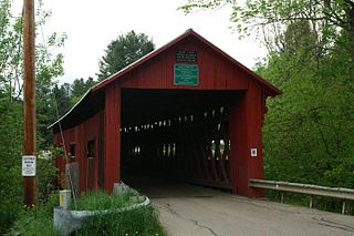
The Church Street Covered Bridge, also called the Village Covered Bridge, is a wooden covered bridge that crosses the North Branch of the Lamoille River in Waterville, Vermont off State Route 109. Built in the late 19th century, it is one of five covered bridges in a space of about five miles that cross the North Branch Lamoille. It was listed on the National Register of Historic Places in 1974.

The Power House Covered Bridge, also known as the School Street Covered Bridge, is a covered bridge from 1872 that crosses the Gihon River off State Route 100C in Johnson, Vermont, US. It was listed on the National Register of Historic Places in 1974. The bridge's name is from a now obsolete hydroelectric generating station just upstream from it. The bridge is of Queen post truss design by an unknown builder.
The Gifford Covered Bridge, also called the C.K. Smith Covered Bridge, is a wooden covered bridge that crosses the Second Branch of the White River in Randolph, Vermont on Hyde Road. It was listed on the National Register of Historic Places in 1974. It is one of two bridges in the state that was uncovered when first built, its trusses boxed for shelter.

The Kingsbury Covered Bridge, also called the Hyde Covered Bridge, is a wooden covered bridge that carries Kingsbury Road across the Second Branch of the White River in Randolph, Vermont. Built in 1904, it is last documented covered bridge to be built in Vermont during the historic 19th and early 20th century period. It was listed on the National Register of Historic Places in 1974.
The Northfield Falls Covered Bridge, also called the Station Covered Bridge, is a wooden covered bridge that carries Cox Brook Road across the Dog River in Northfield, Vermont. Built in 1872, this Town lattice truss bridge is one of five surviving covered bridges in the town, and one of two that are visible from each other. It was listed on the National Register of Historic Places in 1974.

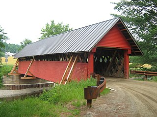
The Slaughter HouseCovered Bridge is a wooden covered bridge that carries Slaughterhouse Road across the Dog River in Northfield, Vermont. The Queen post truss bridge is one of five surviving 19th-century bridges in the town. It was listed on the National Register of Historic Places in 1974.

The Lower Cox Brook Covered Bridge is a wooden covered bridge that crosses Cox Brook in Northfield, Vermont on Cox Brook Road. Built in 1872, it is one of five surviving 19th-century covered bridges in the town, in the only place in Vermont where two historic bridges are visible from each other. It was listed on the National Register of Historic Places in 1974.

The Upper Cox Brook Covered Bridge is a wooden covered bridge that crosses Cox Brook on Cox Brook Road in Northfield, Vermont. It is one of five surviving 19th-century covered bridges in the town, and one of three on the same road. It was listed on the National Register of Historic Places in 1974.

The Morgan Covered Bridge, also known as the Upper Covered Bridge is a wooden covered bridge that crosses the North Branch Lamoille River in Belvidere, Vermont on Morgan Bridge Road. Built about 1887, it is one of two covered bridges in Belvidere, and one of five in a five-mile span that all cross the same river. It was listed on the National Register of Historic Places in 1974.

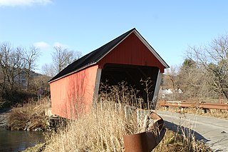
The Montgomery Covered Bridge, also known as the Lower Covered Bridge is a wooden covered bridge that carries Montgomery Road across the North Branch of the Lamoille River in Waterville, Vermont. Built in 1887, it is one of three covered bridges in the town, and one of five on the river in a five-mile span. It was listed on the National Register of Historic Places in 1974.

The Waterman Covered Bridge was an historic covered bridge in Johnson, Vermont that carried Waterman Road across Waterman Creek. Built in 1868, it was one of three surviving 19th-century bridges in the town. It was listed on the National Register of Historic Places in 1974, and collapsed in January 1982.
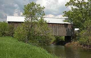
The Howe Covered Bridge is a historic covered bridge carrying Belknap Brook Road across the White River in Tunbridge, Vermont, just east of Vermont Route 110. Built in 1879, it is one of five surviving bridges in the town, one of the highest concentrations of covered bridges in the state. It was listed on the National Register of Historic Places in 1974.

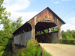
The Larkin Covered Bridge is a historic covered bridge, carrying Larkin Road across the First Branch White River in northern Tunbridge, Vermont. Built in 1902, it is one of the last documented covered bridges to be built in Vermont during the historic period of bridge construction, and is one of five covered bridges in the town. It was listed on the National Register of Historic Places in 1974.

The Mill Covered Bridge is a replica historic covered bridge carrying Spring Road across the First Branch White River in Tunbridge, Vermont. It was built in 2000, nearly replicating a previous structure built on the site in 1883 and lost due to ice damage. It is one of a high concentration of covered bridges in Tunbridge and Chelsea. The 1883 bridge was listed on the National Register of Historic Places in 1974.
The Coburn Covered Bridge is a historic covered bridge, carrying Coburn Road over the Winooski River in eastern East Montpelier, Vermont. Built in 1851, it is the town's only surviving 19th-century covered bridge. It was listed on the National Register of Historic Places in 1974.

The Bradley Covered Bridge is a historic covered bridge, carrying Center Street over Miller Run, a tributary of the Passumpsic River, in Lyndon, Vermont. Built in 1878, it is the last of Vermont's many 19th-century covered bridges to carry a numbered state highway. The bridge was listed on the National Register of Historic Places in 1977.

The Jaynes Covered Bridge is a historic covered bridge, carrying Codding Hollow Road across the North Branch Lamoille River in Waterville, Vermont. Built in 1877, it is one of three 19th-century covered bridges in the town, and one of five to span the North Branch Lamoille in a five-mile span. It was listed on the National Register of Historic Places in 1974.

The Greenbanks Hollow Covered Bridge is a historic covered bridge, carrying Greenbanks Hollow Road across Joes Brook in southern Danville, Vermont. It is the only surviving 19th-century covered bridge in the town. It was listed on the National Register of Historic Places in 1974.

The Red Covered Bridge is a historic covered bridge, carrying Cole Hill Road across Sterling Brook in Morristown, Vermont. Built in 1896, it is the only surviving 19th-century covered bridge in the town, and one of the last to be built during the historic period of covered bridge construction in the state. It is of queen post truss design, and was listed on the National Register of Historic Places in 1974.
The River Road Covered Bridge was a historic covered bridge, carrying Veilleux Road across the Missisquoi River in Troy, Vermont. Built in 1910, the Town lattice truss was the only surviving covered bridge in Troy from the historic period of covered bridge construction when it burned on February 6, 2021. It also exhibited some distinctive variations in construction from more typical Town lattices. It was listed on the National Register of Historic Places in 1974.


