Seefeld Plateau

Last updated

Plateau 47°19′43″N11°11′34″E / 47.32861°N 11.19278°E / 47.32861; 11.19278

Contents

View of the Seefeld Plateau looking west from the Harmelekopf. Behind the Upper Inn valley and the Hohe Munde; right: the Wetterstein Mountains Seefeld.jpg
View of the Seefeld Plateau looking west from the Härmelekopf. Behind the Upper Inn valley and the Hohe Munde; right: the Wetterstein Mountains

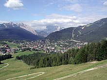
The Seefeld Plateau (German : Seefelder Plateau) is a montane valley and basin landscape in the North Tyrolean Limestone Alps about 500 metres above the Inn valley in the Austrian state of Tyrol. The plateau covers the valley basin around the villages of Seefeld in Tirol and Scharnitz as well as the valley of Leutaschtal.

Location

The Seefeld Plateau runs northwards from the edge of the Inn graben at the Zirler Berg. It lies at a height of around 1,200 m above sea level (AA) in the North Tyrolean Limestone Alps between the Wetterstein Mountains to the northwest, the Mieming Mountains to the west and the Karwendel to the east. The Seefeld Saddle (1,185 m above sea level (AA)), a mountain pass and saddle south of Seefeld, forms a watershed, north of which the plateau drains towards the Isar and south of which it drains into the Inn.

Seefeld in Tirol Austria from ESE on 2014-10-18.png
The Seefeld Plateau as seen from east-south-east with Seefeld in Tirol in the foreground.

Geology and flora

View from Leithen of the Zirler Berg (centre: wooded) Zirler Berg Pestsaule 01.jpg
View from Leithen of the Zirler Berg (centre: wooded)

The dominant rocks of the Seefeld Plateaus are Wetterstein limestone and main dolomite with scattered occurrences of bituminous slate. A branch of the ice age Inn Glacier scoured out several basins and left lakes behind such as the Wildsee, the Möserer See and the Wildmoossee as well as numerous raised bogs like the Reither Moor that were formed by the silting up of lakes. [1]

The plateau lies in the montane altitude zone. On its slopes are fir and beech mixed woods interspersed with spruce. The meadows around the villages are mainly false oat-grass pastures that are used as hay meadows or for grazing. [1]

Economy and transport

View from the Gschwandtkopf looking northeast towards Seefeld in Tirol Seefeld in Tirol panorama.jpg
View from the Gschwandtkopf looking northeast towards Seefeld in Tirol

With around 1.74 million overnight stays per year, evenly divided between winter and summer (as at 2013), [2] tourism is by far the most important economic factor on the Seefeld Plateau. The area has developed itself into a centre for Nordic skiing and was the venue for Nordic competitions in the Winter Olympics of 1964 and 1976, the 1985 Nordic Ski World Championships and many other major events. In summer the Karwendel Alps are a major attraction for hikers and mountain bikers.

The plateau may be reached on the Seefelder Straße (B 177) road that runs over the Seefeld Saddle from the Inn valley as well as other state roads. The Mittenwald Railway also runs across the plateau from north to south, stopping at several stations including Scharnitz, Seefeld and Reith.

Related Research Articles

<span class="mw-page-title-main">Tyrol (federal state)</span> Austrian federal state

Tyrol is an Austrian federal state. It comprises the Austrian part of the historical Princely County of Tyrol. It is a constituent part of the present-day Euroregion Tyrol–South Tyrol–Trentino. The capital of Tyrol is Innsbruck.

<span class="mw-page-title-main">Karwendel</span> Mountain range of the Northern Limestone Alps

The Karwendel is the largest mountain range of the Northern Limestone Alps. It is located on the Austria–Germany border. The major part belongs to the Austrian federal state of Tyrol, while the adjacent area in the north is part of Bavaria, Germany. Four chains stretch from west to east; in addition, there are a number of fringe ranges and an extensive promontory (Vorkarwendel) in the north.

<span class="mw-page-title-main">Tux Alps</span> Subgroup of Austrian Central subgroup of Eastern Alps, Central Europe

The Tux Alps or Tux Prealps are a sub-group of the Austrian Central Alps, which in turn form part of the Eastern Alps within Central Europe. They are located entirely within the Austrian federal state of Tyrol. The Tux Alps are one of three mountain ranges that form an Alpine backdrop to the city of Innsbruck. Their highest peak is the Lizumer Reckner, 2,886 m (AA), which rises between the glen of Wattentaler Lizum and the valley of the Navisbach. Their name is derived from the village of Tux which is tucked away in a side valley of the Zillertal.

<span class="mw-page-title-main">Innsbruck-Land District</span> District in Tyrol, Austria

The Bezirk Innsbruck-Land is an administrative district (Bezirk) in Tyrol, Austria. It encloses the Statutarstadt Innsbruck, and borders Bavaria (Germany) in the north, the district Schwaz in the east, South Tyrol in Italy to the south, and the district of Imst in the west.

<span class="mw-page-title-main">Seefeld in Tirol</span> Place in Tyrol, Austria

Seefeld in Tirol is an old farming village, now a major tourist resort, in Innsbruck-Land District in the Austrian state of Tyrol with a local population of 3,312. The village is located about 17 km (11 mi) northwest of Innsbruck on a plateau between the Wetterstein mountains and the Karwendel on a historic road from Mittenwald to Innsbruck that has been important since the Middle Ages. It was first mentioned in 1022 and since the 14th century has been a pilgrimage site, benefiting not only from the visit of numerous pilgrims but also from its stacking rights as a trading station between Augsburg and the Venice. Also since the 14th century, Tyrolean shale oil has been extracted in the area. Seefeld was a popular holiday resort even before 1900 and, since the 1930s, has been a well known winter sports centres and amongst the most popular tourist resorts in Austria. The municipality, which has been the venue for several Winter Olympics Games, is the home village of Anton Seelos, the inventor of the parallel turn.

Leutasch is a municipality in the northern part of the district Innsbruck-Land in the Austrian state of Tyrol about 30 km northwest of Innsbruck and 10 km northwest of Seefeld in Tirol

<span class="mw-page-title-main">Wetterstein</span> Mountain group in the Northern Limestone Alps

The Wetterstein mountains, colloquially called Wetterstein, is a mountain group in the Northern Limestone Alps within the Eastern Alps, crossing the Austria–Germany border. It is a comparatively compact range located between Garmisch-Partenkirchen, Mittenwald, Seefeld in Tirol and Ehrwald along the border between Germany (Bavaria) and Austria (Tyrol). Zugspitze, the highest peak is at the same time the highest mountain in Germany.

<span class="mw-page-title-main">Arnspitze Group</span> Austrian-German mountain chain

The Arnspitze Group is a free-standing mountain chain in Austrian and Germany, in the states of Tyrol and Bavaria, between Seefeld in Tirol and Mittenwald, and between the Leutasch valley in the west and the Isar valley near Scharnitz in the east. In the literature, the Arnspitze Group is classed as part of the Wettersteingebirge. The majority of the group belongs to Tyrol, a northeastern part of the chain lies in Bavaria. The border between Bavaria and Tyrol runs over the summit of the Große Arnspitze.

<span class="mw-page-title-main">Mieming Range</span>

The Mieming(er) Range, Mieminger Chain or Mieminger Mountains, is a mountain range of the Northern Limestone Alps in the Eastern Alps. It is located entirely in Austria within the state of Tyrol. This sub-group is somewhat in the shadows of its more famous neighbour, the Wetterstein to the north. Whilst the region around the Coburger Hut and the lakes of Seebensee and Drachensee in the west and the Hohe Munde in the extreme east receive large numbers of visitors, the less developed central area remains very quiet. The Hohe Munde is also a popular and challenging ski touring destination.

<span class="mw-page-title-main">Mittenwald Railway</span> Railway line in Austria and Germany

The Mittenwald Railway, popularly known as the Karwendelbahn, is a railway line in the Alps in Austria and Germany. It connects Innsbruck via Seefeld and Mittenwald to Garmisch-Partenkirchen.

<span class="mw-page-title-main">Erlspitze Group</span>

The Erlspitze Group, also called the Seefeld Group, is the southwesternmost side range of the Austrian part of the Karwendel mountains in the Alps. It forms a horseshoe-shaped highland around the valley of Eppzirler Tal and is joined in the south to the Nordkette by the Erl Saddle (Erlsattel) near Solsteinhaus. It is bounded in the west by the Seefeld Basin, in the east by the valleys of the Gleirschtal and the Großes Kristental; its forested northern foothills reach as far as Scharnitz.

<span class="mw-page-title-main">Scharnitz Pass</span>

The Scharnitz Pass is a narrow section of the upper Isar valley in the Northern Limestone Alps. It lies at a height of about 955 m on the Austro-German border between the states of Bavaria and Tyrol. Its name derives from the village of Scharnitz immediately to the south.

<span class="mw-page-title-main">Porta Claudia</span>

The Porta Claudia is a former fortification at the Scharnitz Pass, where the valley of the River Isar narrows near the village of Scharnitz, on the Bavarian border near Mittenwald. The Porta Claudia – or more precisely the Scharnitz Pass – is the start of the present federal highways, the B 2 (Germany) and the B 177 (Austria).

<i>Seefelder Straße</i>

Seefelder Straße (B 177) is a 21.2 km long former federal road or Bundesstraße - now classified as a "priority road" or Straße mit Vorrang - in the Alps in the Austrian federal state of Tyrol. It links the Inn valley with Scharnitz and the Scharnitz Pass on the border with Germany, running past the Zirler Berg, over the Seefeld Saddle and past Seefeld. It is part of the E533 European route.

<span class="mw-page-title-main">Nördlinger Hut</span> Alpine Club hut in Tyrol, Austria

The Nördlinger Hut is an Alpine Club hut belonging to the German Alpine Club that is situated at a height of 2,238 m (AA) south of the summit of the Reither Spitze in the Austrian state of Tyrol. It is thus the highest refuge hut in the entire Karwendel range. It is located in the westernmost part of the Karwendel Alps, the Erlspitze Group, above the village and ski resort of Seefeld. From the hut there are expansive views over the Stubai Alps, the Inn valley and the Wetterstein Mountains.

<span class="mw-page-title-main">Seefelder Spitze</span>

The Seefelder Spitze is a mountain east of Seefeld in Tirol in the Karwendel Alps in the Austrian state of Tyrol. It is 2,221 metres high and there is a summit cross at the top.

The Region Seefeld is a tourist region in Tyrol, Austria. It provides the entire infrastructure of a Nordic centre for winter sport and a wide range of facilities for the summer season.

<span class="mw-page-title-main">Zirler Berg</span> Mountain in Tyrol, Austria

The Zirler Berg near Zirl in the Austrian federal state of Tyrol is a mountain, 1,057 m (AA) high, in the Karwendel Alps, a western part of the Northern Limestone Alps. It is a southern foothill of the Reither Spitze (2,374 m) and is known mainly because the Seefelder Straße (B 177) on its southern slopes climbs through 388 metres in a distance of less than 4 kilometres from Zirl in the Inn valley to Leithen on the Seefeld Plateau.

<span class="mw-page-title-main">Seefeld Saddle</span>

The Seefeld Saddle is a saddle and mountain pass, 1,185 m (AA), in the Northern Limestone Alps in the Austrian federal state of Tyrol. Two major transport routes run over it: the Seefelder Straße (B 177) and the Mittenwald Railway. On the Seefeld Plateau north of the saddle lies the village and ski resort of Seefeld in Tirol.

<span class="mw-page-title-main">Northern Karwendel Chain</span>

The Northern Karwendel Chain is the northernmost of the four great, largely parallel mountain chains in the Karwendel in the Alps. It is made from very pure Wetterstein limestone, which has its heart in the Karwendel and runs for a total length of c. 18 kilometres from Scharnitz in the northeast via Mittenwald to the Wörner, where it turns sharply east, until it finally ends west of the Johannestal valley. It has 25 main summits with an average height of 2,400 m. The highest peak is the Eastern Karwendelspitze. The boundary between Germany and Austria runs along the crest from the Brunnensteinspitze in the west to the Eastern Karwendelspitze in the east. The northwestern side is Bavarian, the southeastern flank is Tyrolean. The Northern Karwendel Chain should not be confused with the southernmost chain of the Karwendel, the Inn Valley Chain, which is known colloquially as the Nordkette or "North Chain" due to its location north of the city of Innsbruck.

References

  1. 1 2 Andrea Bucher, Wolfgang Hofbauer, Georg Gärtner: Beitrag zur Moosflora von Seefeld und Umgebung und des Leutascher Beckens (Nordtirol). In: Berichte des naturwissenschaftlich-medizinischen Vereins in Innsbruck, Vol. 80 (1993), pp. 53–67 (pdf; 2.6 MB)
  2. State of Tyrol: Regional profile Seefeld Plateau – 2014 statistics (pdf; 734 kB)