
The Breg is a river, 46 kilometres long, in Baden-Württemberg, Germany, and the primary headstream of the Danube.

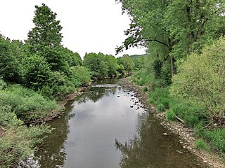
The Brigach is the shorter of two streams that jointly form the river Danube in Baden-Württemberg, Germany. The Brigach has its source at 925 m (3,035 ft) above sea level within St. Georgen in the Black Forest. The Brigach crosses the city Villingen-Schwenningen. 40.4 km (25.1 mi) from the source, the Brigach joins the Breg in Donaueschingen to form the Danube River.

The White Main, is the larger and shorter of the two headstreams of the river Main. It rises in the Fichtelgebirge and merges near Steinenhausen, southwest of Kulmbach, with the left-hand, southern headstream, the Red Main, to form the Main. The length of the White Main is 51.7 km. The source of the White Main lies on light granite rock, which lends it its white colouration.

The Tualatin River is a tributary of the Willamette River in Oregon in the United States. The river is about 83 miles (134 km) long, and it drains a fertile farming region called the Tualatin Valley southwest and west of Portland at the northwest corner of the Willamette Valley. There are approximately 500,000 people residing on 15 percent of the land in the river's watershed.

The Hogsmill River in Surrey and Greater London, England is a small chalk stream tributary of the River Thames. It rises in Ewell and flows into the Thames at Kingston upon Thames on the lowest non-tidal reach, that above Teddington Lock.

The Franconian Saale is a 140 km long river in Bavaria, Germany. It is a right-bank tributary of the Main, in Lower Franconia. It should not be confused with the larger Saxon Saale, which is a tributary of the Elbe River.
The Enz is a river flowing north from the Black Forest to the Neckar in Baden-Württemberg. It is 106 km long.
The Sauer is a river in France (Alsace) and Germany (Rhineland-Palatinate). A left tributary of the river Rhine, its total length is about 85 kilometres (53 mi), of which 64 km (40 mi) in France. Its upper course, in Germany, is called Saarbach. Its source is in the Palatinate forest, near the French border, south of Pirmasens. It flows into France near Schœnau, and continues through Wœrth and north of Haguenau. It flows into the Rhine in Seltz, opposite the mouth of the Murg.

The Kinzig is a river, 87 kilometres long, in southern Hesse, Germany. It is a right tributary of the Main. Its source is in the Spessart hills at Sterbfritz, near Schlüchtern. The Kinzig flows into the Main in Hanau. The Main-Kinzig-Kreis (district) was named after the river. The towns along the Kinzig are Schlüchtern, Steinau an der Straße, Bad Soden-Salmünster, Gelnhausen, and Hanau. The Kinzig is first recorded in 815 A.D. as Chinzicha.

The Murr (help·info) is a river in Baden-Württemberg, Germany, right tributary of the Neckar. The river gave its name to a small town on its banks, Murr, and to the Rems-Murr-Kreis district, which was also named after the river Rems, which runs roughly parallel to the south of the Murr.
The Wiese is a river, 57.8 kilometres long, and a right-hand tributary of the Rhine in southwest Germany and northwest Switzerland.

Saint-Paul-la-Roche, is a commune in the northeast of the Dordogne department in the Nouvelle-Aquitaine region in southwestern France. The commune is integrated into the Regional Natural Parc Périgord Limousin.

The Red Main is a river in southern Germany. It is the southern, left headstream of the river Main. It rises in the hills of Franconian Switzerland, near Haag and flows generally northwest through the towns Creußen, Bayreuth, Heinersreuth and Neudrossenfeld. It merges with the White Main near Kulmbach to form the Main. The Red Main is 72 kilometres (45 mi) long and descends a total of 283 metres (928 ft).

The Oder is a 56-kilometre-long (35 mi) river in Lower Saxony, Germany, and a right tributary of the Rhume. Its source is in the Harz mountains, near Sankt Andreasberg. It flows southwest through Bad Lauterberg, Pöhlde and Hattorf am Harz. The Oder flows into the Rhume in Katlenburg-Lindau.

The Aschau is a stream in the Südheide Nature Park in Lower Saxony, Germany, It is a tributary of the Lachte, which in turn discharges into the Aller.
The Steinlach is a river with a length of 26 km (16 mi) in Baden-Württemberg, Germany. It is a tributary to the Neckar.

The Püttlach is a left tributary of the River Wiesent. It is about 27 km (17 mi) long and flows through the Bavarian region of Franconian Switzerland in Germany.

The Rotbach is the 19.9-kilometre-long, left-hand and southeasterly headstream of the Dreisam in the Southern Black Forest in the south German state of Baden-Württemberg.

Bieber is a river of Hesse, Germany. It flows into the Rodau in Mühlheim am Main.

The Moosbach is a stream, approximately 6.6 kilometres (4.1 mi) long, in the South Palatine part of the Wasgau region in the German state of Rhineland-Palatinate. It is a right tributary of the Lauter, whose upper reaches are known as the Wieslauter.


