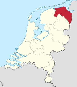
Groningen is the northeasternmost province of the Netherlands. It borders on Friesland to the west, Drenthe to the south, the German state of Lower Saxony to the east, and the Wadden Sea to the north. As of February 2020, Groningen had a population of 586,309 and a total area of 2,960 km2 (1,140 sq mi).

Overijssel is a province of the Netherlands located in the eastern part of the country. The province's name translates to "across the IJssel", from the perspective of the Episcopal principality of Utrecht by which it was held until 1528. The capital city of Overijssel is Zwolle and the largest city is Enschede. The province had a population of 1,162,215 as of November 2019. The land mostly consists of grasslands and some forests ; it also borders a small part of the IJsselmeer to the west.

Assen is a municipality and a city in the northeastern Netherlands, and is the capital of the province of Drenthe. It received city rights in 1809. Assen is known for TT Circuit Assen, the motorcycle racing circuit, where on the last Sunday in June the Dutch TT is run; and also for the annual Assen Dance Festival.

Stadskanaal is a town and municipality with a population of 32,715 in the province of Groningen in the northeast of the Netherlands. It was named after the canal Stadskanaal.

Barger-Compascuum is a village in the Dutch municipality of Emmen. It is in a peat-producing region of Drenthe. Veenpark, an open-air museum, is dedicated to the peat history of the region.

Ter Apel is a village with a population of 8,866 residents in the municipality Westerwolde in the northern Netherlands, in the province Groningen in the region Westerwolde. The town lies on the stream Ruiten Aa, which has the valley that together with the Ter Apeler forest belongs to the national network of nature reserves, the Ecologische Hoofdstructuur. An accommodation centre for refugees is located at Ter Apel, functioning as a "departure centre" for rejected refugees and a registration point, operated by the Centraal Orgaan opvang Asielzoekers. Ter Apel lies on the roads N366, N976 and N391. It forms the southern point of the border between Groningen and Drenthe, the Semslinie.
Eexterveenschekanaal is a village in the Dutch province of Drenthe. It is a part of the municipality of Aa en Hunze, and lies about 19 km east of Assen.
Gasselternijveen is a village in the Dutch province of Drenthe. It is a part of the municipality of Aa en Hunze, and lies about 20 km east of Assen.

Nieuw-Buinen is a village in the Dutch province of Drenthe. It is a part of the municipality of Borger-Odoorn, and lies about 21 kilometres (13 mi) north of Emmen.

1e Exloërmond is a village in the Dutch province of Drenthe. It is a part of the municipality of Borger-Odoorn, and lies about 18 km north of Emmen.

Valthermond is a village in the Dutch province of Drenthe. It is a part of the municipality of Borger-Odoorn, and lies about 18 km north of Emmen.
Ter Apelkanaal is a town in the Dutch province of Groningen. It is a part of the municipality of Westerwolde, and lies about 17 km (11 mi) northeast of Emmen.

Nieuwleusen is a town in the Dutch province of Overijssel with 9300 inhabitants as of 2021. In the 2001 municipal reform, most of the former municipality of Nieuwleusen was incorporated into the municipality of Dalfsen. Some parts of the former municipality, including the Lichtmis area, was added to the neighbouring municipality of Zwolle.

Emmer-Compascuum is a village in the Netherlands and is part of the Emmen municipality in Drenthe.

The Bourtanger Moor was a bog in eastern parts in the Dutch provinces of Drenthe and Groningen and the bordering German districts of Bentheim and Emsland. A remaining stretch on the border between Drenthe and the districts Emsland and Betheim is now a nature reserve, the Internationaler Naturpark Bourtanger Moor-Bargerveen.
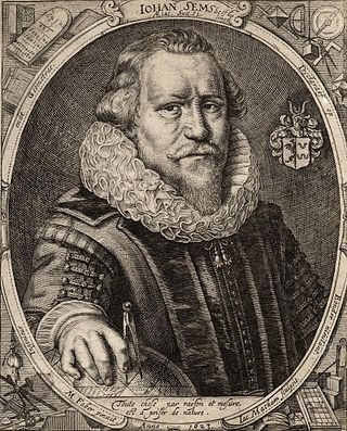
Johan Sems, sometimes known as Johan Semp, was a Dutch cartographer, engineer and land surveyor. He specialized in land reclamation and the building of dikes and fortifications.

Zandberg is a village in the north of the Netherlands, partly located in the Groningen municipality of Westerwolde and partly in the Drenthe municipality of Borger-Odoorn. The village was created in the early nineteenth century as a settlement in the peat colonies. The first residents came from the neighboring part of Germany. Zandberg is therefore one of the Catholic enclaves in the Northern Netherlands.

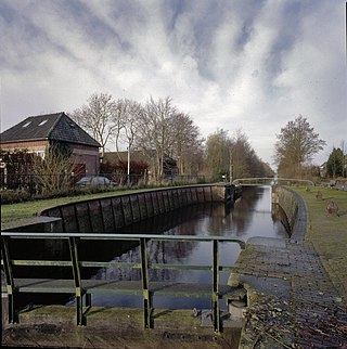
Pekel A (also Pekel Aa; Dutch pronunciation:[ˈpeːkəlaː]) is a river in the Province of Groningen in the Netherlands. The villages of Oude Pekela and Nieuwe Pekela have been named after the river. The name translates to Brine (Pekel) River (A), and used to flow from the Dollart into a large raised bog. The Dollart was poldered from the 15th century until 1924, and the river now has its source at the confluence with the Westerwoldsche Aa at De Bult. The river was canalised and extended. The part from Oude Pekela to Stadskanaal was renamed Pekelderdiep. From 1599 until 1810, the area through which the river flowed, was a peat colony. In the 20th century, the Pekel A was a heavily polluted river, but it has been cleaned up since the 1970s.

Musselkanaal is a town in the Dutch province of Groningen. It is located in the municipality of Stadskanaal. It was established by the city of Groningen in the 1840s to exploit the peat. It used to be part of the municipality of Onstwedde, but was merged into Stadskanaal in 1968.

Bareveld is a Dutch village on the border of the provinces of Groningen and Drenthe. The Drenthe part of the village belongs to the municipality of Aa en Hunze, the Groningen part of the village has been added to the municipality of Veendam. It is located on the N33, in between the linear villages of Eexterveenschekanaal and Nieuwediep.
