Related Research Articles

The Allegheny River is a 325-mile (523 km) long headwater stream of the Ohio River in western Pennsylvania and New York, United States. The Allegheny River runs from its headwaters just below the middle of Pennsylvania's northern border northwesterly into New York then in a zigzag southwesterly across the border and through Western Pennsylvania to join the Monongahela River at the Forks of the Ohio on the "Point" of Point State Park in Downtown Pittsburgh, Pennsylvania. The Allegheny River is, by volume, the main headstream of both the Ohio and Mississippi Rivers. Historically, the Allegheny was considered to be the upper Ohio River by both Native Americans and European settlers.

Idabel is a city in and county seat of McCurtain County, Oklahoma, United States. The population was 7,010 at the 2010 census. It is located in the southeast corner of Oklahoma, a tourist area known as Choctaw Country.

The Oklahoma Panhandle is the extreme northwestern region of the U.S. state of Oklahoma, consisting of Cimarron County, Texas County and Beaver County, from west to east. As with other salients in the United States, its name comes from the similarity of its shape to the handle of a pan.

Kenton is a census designated place (CDP) in Cimarron County, Oklahoma, United States. Kenton is the westernmost town in Oklahoma. From Kenton, it is approximately 155 miles (249 km) south to Amarillo, Texas, 237 miles (381 km) northwest to Colorado Springs, Colorado, 306 miles (492 km) northwest to Denver, Colorado, 314 miles (505 km) southwest to Albuquerque, New Mexico, and 361 miles (581 km) southeast to Oklahoma City, the nearest major population centers.

Sierra Grande is an extinct stratovolcano in northeastern New Mexico that rises 2,200 feet above the surrounding plain. It is part of the inactive Raton-Clayton volcanic field.

State Highway 2, abbreviated SH-2 or OK-2, is a designation for two distinct highways maintained by the U.S. state of Oklahoma. Though they were once connected, the middle section of highway was concurrent with three different U.S. highways, so the middle section was decommissioned for reasons of redundancy.

State Highway 10 is a state highway in northeastern Oklahoma. It makes a 233.1 miles (375.1 km) crescent through the northeast corner of the state, running from SH-99 in Osage County to Interstate 40 (I-40) near Gore. It has two lettered spur routes.
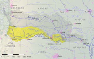
The Beaver River is an intermittent river, 280 miles (450 km) long, in western Oklahoma and northern Texas in the United States. It is a tributary of the North Canadian River, draining an area of 11,690 square miles (30,300 km2) in a watershed that extends to northeastern New Mexico and includes most of the Oklahoma Panhandle.

Clayton Lake State Park is a state park of New Mexico, United States, featuring a 170-acre (69 ha) recreational reservoir and a fossil trackway of dinosaur footprints. It is located 15 miles (24 km) north of Clayton, close to New Mexico's border with Colorado, Oklahoma, and Texas. The park is accessed via New Mexico State Road 455. The landscape is characterized by rolling grasslands, volcanic rocks, and sandstone bluffs, set on the western edge of the Great Plains. The park area was a stopover point for travelers along the Cimarron Cutoff of the Santa Fe Trail.
U.S. Route 412 is a U.S. highway in the south-central portion of the United States, connecting Springer, New Mexico to Columbia, Tennessee. A 504.11-mile (811.29 km) section of the highway crosses the state of Oklahoma, traversing the state from west to east. Entering the state southwest of Boise City, US-412 runs the length of the Oklahoma Panhandle and serves the northern portion of the state's main body, before leaving the state at West Siloam Springs. Along the way, the route serves many notable cities and towns, including Boise City, Guymon, Woodward, Enid, and the state's second-largest city, Tulsa.
The Carrizo Creek of New Mexico and Texas is a 145-mile-long (233 km) river. It is a tributary of Rita Blanca Creek, itself a tributary of the Canadian River. Via the Arkansas and Mississippi rivers, water from Carrizo Creek eventually reaches the Gulf of Mexico. It is sometimes also known as the Carrizo River.
Coldwater Creek is an intermittently-flowing stream in northeastern New Mexico, and the panhandles of Oklahoma and Texas. As far back as 1907, the USGS reported that Coldwater Creek is a dry sand bed most of the year. One source says that Coldwater Creek is also known as Rabbit Ears Creek, because it rises near Rabbit Ears, a pair of mountain peaks in Union County, New Mexico. According to the United States Geological Survey (USGS), Coldwater Creek drains an area of 1,903 square miles (4,930 km2).
Kiowa Creek is a watercourse in Texas and Oklahoma that becomes a tributary of the Beaver River. It originates southwest of Huntoon and east of Perryton in northeastern Ochiltree County, Texas. It travels generally east until southwest of Darrouzett in Lipscomb County, then turns northeast and passes just south and east of that town. It continues generally northeasterly into Beaver County, Oklahoma, where it is joined by Camp Creek. The stream enters Harper County west of Laverne, Oklahoma, and continues to its joinder with the Beaver River north-northwest of Laverne.
U.S. Route 64 (US-64) is a U.S. highway running from the Four Corners area to the Outer Banks of North Carolina. Between these two points, the highway passes through the entire width of Oklahoma; a total of 591.17 miles (951.40 km) of US-64 lies in the state of Oklahoma. US-64 enters the state from New Mexico, crossing the line between the two states between Clayton, New Mexico, and Boise City in Cimarron County. The route runs the full length of the Oklahoma Panhandle, then serves the northernmost tier of counties in the main body of the state before dipping southeastward to Tulsa, the state's second-largest city. From Tulsa, the highway continues southeast, leaving Oklahoma just west of Fort Smith, Arkansas. In addition to Tulsa, US-64 serves fifteen Oklahoma counties and the cities of Guymon, Woodward, Enid, and Muskogee.

The Mesa Rica Sandstone is a geologic formation in Oklahoma and New Mexico. It preserves fossils dating back to the Cretaceous period.
South Carrizo Creek forms either just west of the Oklahoma line in New Mexico, or east inside Oklahoma to the northwest of Wheeless, Oklahoma. It is intermittent. It travels generally northeast through Black Mesa State Park where it is impounded to form Lake Carl Etling, before being joined by Willow Creek and continuing northeast to flow into the Cimarron River.
Carrizo Creek forms in Arizona north of Cibecue, before flowing generally southeast, being joined by Corduroy Creek around the town of Carrizo, and continuing generally south to join the Salt River.
Carrizozo Creek is a watercourse in the northeast corner of New Mexico, with a small portion extending into the northwestern Oklahoma Panhandle. The creek originates northwest of Clayton Lake State Park and northeast of Grenville, New Mexico about halfway to the Colorado border, being just north of Corrumpa Creek and just west of New Mexico State Road 370. It meanders generally east-northeast into Oklahoma, loops northwest heading back into New Mexico, and then turns generally east flowing into Oklahoma again. Where Carrizozo Creek and the Dry Cimarron River come together in Cimarron County, Oklahoma west of Kenton, the Cimarron River is formed.
Corrumpa Creek is a watercourse in New Mexico and Oklahoma. It originates at Weatherly Lake, located 9 miles east-southeast of Des Moines in Union County, New Mexico. It results from the South Branch Corrumpa Creek, which originates south-southwest of Des Moines and travels generally east, and the North Branch Corrumpa Creek, which originates southwest of Des Moines but passes northeast through the town before continuing generally east-southeast, having their confluence at Weatherly Lake. From that location, Corrumpa Creek meanders in every direction but generally east before turning southeast near the Oklahoma border. It continues into Oklahoma where, at the point where it is joined by Seneca Creek about 4.5 miles northwest of Felt, Oklahoma, it officially becomes the Beaver River.
Lake Evans Chambers, also known as Evans Chambers Lake, is a fishing lake constructed by the Oklahoma Department of Wildlife Conservation in 1965 in Beaver County, Oklahoma, 18 miles west of Laverne. The lake has 80 acres of surface area, and 2.8 miles of shoreline. The lake has a boat ramp, and anglers may find Largemouth Bass, White Bass, White Crappie, Black Crappie, Bluegill Sunfish, Channel Catfish, and Walleye.
References
- 1 2 "Beaver-Canadian-River". Where Eagles Fly. Retrieved August 18, 2021.
- 1 2 "Seneca Creek". Natural Atlas. Retrieved August 18, 2021.
- ↑ "Feature Detail Report for: Beaver River". USGS. Retrieved August 18, 2021.
- ↑ "Clayton Lake State Park and Dinosaur Trackways". Google Maps. Retrieved August 19, 2021.
- ↑ "Clayton, New Mexico to Clayton Lake State Park and Dinosaur Trackways". Google Maps. Retrieved August 19, 2021.
- 1 2 "Clayton Lake State Park". New Mexico Bureau of Geology and Mineral Resources. Retrieved August 19, 2021.
- ↑ "Clayton Lake State Park and Dinosaur Trackways, NM". New Mexico State Parks. Retrieved August 19, 2021.
- ↑ "Clayton Lake State Park and Dinosaur Trackways". NewMexico.org. Retrieved August 19, 2021.