Grenville, New Mexico

Last updated

Grenville, New Mexico
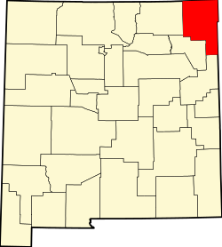
Union County New Mexico Incorporated and Unincorporated areas Grenville Highlighted.svg
Location of Grenville, New Mexico
Usa edcp location map.svg
Red pog.svg
Grenville, New Mexico
Location in the United States
Coordinates: 36°35′26″N103°36′52″W / 36.59056°N 103.61444°W / 36.59056; -103.61444
Country United States
State New Mexico
County Union
Area
[1]
  Total0.38 sq mi (0.98 km2)
  Land0.38 sq mi (0.98 km2)
  Water0.00 sq mi (0.00 km2)
Elevation
[2]
5,971 ft (1,820 m)
Population
 (2020) [3]
  Total22
  Density58.05/sq mi (22.43/km2)
Time zone UTC-7 (Mountain (MST))
  Summer (DST) UTC-6 (MDT)
ZIP code
88424
Area code 575
FIPS code 35-30770
GNIS feature ID2413556 [2]

Grenville is a village in Union County, New Mexico, United States. The population was 38 at the 2010 census.

Contents

Geography

According to the United States Census Bureau, the village has a total area of 0.6 square miles (1.6 km2), all land.

Demographics

Historical population
CensusPop.Note
1930 231
1940 143−38.1%
1950 102−28.7%
1960 55−46.1%
1970 21−61.8%
1980 3985.7%
1990 24−38.5%
2000 254.2%
2010 3852.0%
2020 22−42.1%
U.S. Decennial Census [4] [3]

As of the census [5] of 2000, there were 25 people, 9 households, and 6 families residing in the village. The population density was 39.8 inhabitants per square mile (15.4/km2). There were 14 housing units at an average density of 22.3 units per square mile (8.6 units/km2). The racial makeup of the village was 100.00% White.

There were 9 households, out of which 33.3% had children under the age of 18 living with them, 66.7% were married couples living together, and 33.3% were non-families. 33.3% of all households were made up of individuals, and 33.3% had someone living alone who was 65 years of age or older. The average household size was 2.78 and the average family size was 3.67.

In the village, the population was spread out, with 32.0% under the age of 18, 4.0% from 18 to 24, 20.0% from 25 to 44, 16.0% from 45 to 64, and 28.0% who were 65 years of age or older. The median age was 40 years. For every 100 females, there were 108.3 males. For every 100 females age 18 and over, there were 70.0 males.

The median income for a household in the village was $54,375, and the median income for a family was $58,125. Males had a median income of $0 versus $0 for females. The per capita income for the village was $21,536. None of the population and none of the families were below the poverty line.

Related Research Articles

<span class="mw-page-title-main">Vandiver, Missouri</span> Village in Missouri, United States

Vandiver is a village in Audrain County, Missouri, United States. As of the 2010 census, the village population was 77.

<span class="mw-page-title-main">Penermon, Missouri</span> Village in Missouri, United States

Penermon is a village in Stoddard County, Missouri, United States. The population was 64 at the 2010 census.

<span class="mw-page-title-main">Lewiston, Nebraska</span> Village in Nebraska, United States

Lewiston is a village in northwest Pawnee County, Nebraska, United States. The population was 54 at the 2020 census.

<span class="mw-page-title-main">Malmo, Nebraska</span> Village in Saunders County, Nebraska, United States

Malmo is a village in Saunders County, Nebraska, United States. The population was 94 at the 2020 census.

<span class="mw-page-title-main">Weston, Nebraska</span> Village in Saunder County, Nebraska, United States

Weston is a village in Saunders County, Nebraska, United States. The population was 250 at the 2020 census.

<span class="mw-page-title-main">Bartlett, Nebraska</span> Village in and county seat of Wheeler County, Nebraska, United States

Bartlett is a village in, and the county seat of, Wheeler County, Nebraska, United States. The population was 117 at the 2010 census.

<span class="mw-page-title-main">Champ, Missouri</span> Village in Missouri, United States

Champ is a village in St. Louis County, Missouri, United States. The population was 10 at the 2020 census.

<span class="mw-page-title-main">North Kingsville, Ohio</span> Village in Ohio, United States

North Kingsville is a village in Ashtabula County, Ohio, United States. The population was 2,742 at the 2020 census.

<span class="mw-page-title-main">Valleyview, Ohio</span> Village in Ohio, United States

Valleyview is a village in Franklin County, Ohio, United States. The population was 669 at the 2020 census.

<span class="mw-page-title-main">Lowellville, Ohio</span> Village in Ohio, United States

Lowellville is a village in eastern Mahoning County, Ohio, United States, along the Mahoning River. The population was 996 at the 2020 census. Located about 8 miles (13 km) southeast of Youngstown, it is part of the Youngstown–Warren metropolitan area.

<span class="mw-page-title-main">Roswell, Ohio</span> Village in Ohio, United States

Roswell is a village in Tuscarawas County, Ohio, United States. The population was 219 at the 2020 census.

<span class="mw-page-title-main">Grenville, South Dakota</span> Town in South Dakota, United States

Grenville is a town in Day County, South Dakota, United States. The population was 48 at the 2020 census.

<span class="mw-page-title-main">Bellevue, Wisconsin</span> Village in Wisconsin, United States

Bellevue is a village in Brown County, Wisconsin. It was a town until incorporating as a village on February 14, 2003. The population was 15,935 at the time of the 2020 census. Bellevue is part of the Green Bay metropolitan area. Bellevue sits around 4.34 miles (6.99 km) east from central Green Bay.

<span class="mw-page-title-main">Hilbert, Wisconsin</span> Village in Wisconsin, United States

Hilbert is a village in Calumet County in the U.S. state of Wisconsin. The population was 1,132 at the 2010 census.

<span class="mw-page-title-main">Kekoskee, Wisconsin</span> Village in Wisconsin, United States

Kekoskee is a village in Dodge County, Wisconsin, United States. The population was 161 at the 2010 census.

<span class="mw-page-title-main">Avoca, Wisconsin</span> Village in Wisconsin, United States

Avoca is a village in Iowa County, Wisconsin, United States. The population was 637 at the 2010 census. It is part of the Madison Metropolitan Statistical Area. It is named after Avoca in Ireland.

<span class="mw-page-title-main">Yuba, Wisconsin</span> Village in Wisconsin, United States

Yuba is a village in Richland County, Wisconsin, United States. The population was 74 at the 2010 census. Yuba is 11 miles southwest of Hillsboro and 17 miles north of Richland Center. County Hwy C runs through the village.

<span class="mw-page-title-main">Wilson, Ohio</span> Village in Ohio, United States

Wilson is a village in Belmont and Monroe counties in the U.S. state of Ohio. The population was 129 at the 2020 census. It is part of the Wheeling metropolitan area.

<span class="mw-page-title-main">Mount Hope, Wisconsin</span> Village in Wisconsin, United States

Mount Hope is a village in Grant County, Wisconsin, United States. The population was 225 at the 2010 census. The village is located within the Town of Mount Hope.

<span class="mw-page-title-main">Arena, Wisconsin</span> Village in Wisconsin, United States

Arena is a village in Iowa County, Wisconsin, United States. The population was 834 at the 2010 census. The village is located within the Town of Arena. It is part of the Madison Metropolitan Statistical Area.

References

  1. "ArcGIS REST Services Directory". United States Census Bureau. Retrieved October 12, 2022.
  2. 1 2 U.S. Geological Survey Geographic Names Information System: Grenville, New Mexico
  3. 1 2 "Census Population API". United States Census Bureau. Retrieved October 12, 2022.
  4. "Census of Population and Housing". Census.gov. Retrieved June 4, 2015.
  5. "U.S. Census website". United States Census Bureau . Retrieved January 31, 2008.