Amistad, New Mexico | |
|---|---|
 Amistad Museum, May 2008 | |
 Amistad, New Mexico  Amistad, New Mexico | |
| Coordinates: 35°55′08″N103°09′14″W / 35.91889°N 103.15389°W | |
| Country | United States |
| State | New Mexico |
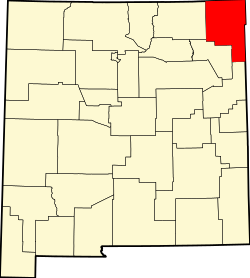
| County | Union |
| Elevation | 4,472 ft (1,363 m) |
| Population | |
• Total | 137 |
| Time zone | UTC-7 (MST) |
| • Summer (DST) | UTC-6 (MDT) |
| ZIP Code | 88410 |
| Area code | 575 |
| GNIS feature ID | 898619 [1] |
Amistad is an unincorporated community in Union County, New Mexico, United States. It is located approximately 39 miles south of Clayton on State Route 402.