Des Moines, New Mexico

Last updated

Des Moines, New Mexico
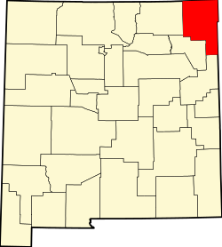
Union County New Mexico Incorporated and Unincorporated areas Des Moines Highlighted.svg
Location of Des Moines, New Mexico
Usa edcp location map.svg
Red pog.svg
Des Moines, New Mexico
Location in the United States
Coordinates: 36°45′41″N103°50′03″W / 36.76139°N 103.83417°W / 36.76139; -103.83417
Country United States
State New Mexico
County Union
Named for Des Moines, Iowa
Area
[1]
  Total0.87 sq mi (2.25 km2)
  Land0.87 sq mi (2.25 km2)
  Water0.00 sq mi (0.00 km2)
Elevation
[2]
6,634 ft (2,022 m)
Population
 (2020) [3]
  Total117
  Density134.48/sq mi (51.92/km2)
Time zone UTC-7 (Mountain (MST))
  Summer (DST) UTC-6 (MDT)
ZIP code
88418
Area code 575
FIPS code 35-20480
GNIS feature ID2413546 [2]

Des Moines is a village in Union County, New Mexico, United States. The population was 143 at the 2010 census. In 2018, the estimated population was 20% lower than it was in 2000. Des Moines is a small village surrounded by large cattle ranches. Des Moines is known for its educational services, construction, and agriculture.

Contents

History

A post office called Des Moines has been in operation since 1906. [4] The village took its name after Des Moines, Iowa. [5]

Geography

According to the United States Census Bureau, the village has a total area of 1.1 square miles (2.8 km2), all land.

The summit of Sierra Grande, the largest shield volcano in the Raton-Clayton Volcanic Field, is 5 kilometres (3.1 mi) southwest of the village.

Demographics

Historical population
CensusPop.Note
1930 362
1940 289−20.2%
1950 282−2.4%
1960 207−26.6%
1970 204−1.4%
1980 178−12.7%
1990 168−5.6%
2000 1775.4%
2010 143−19.2%
2020 117−18.2%
U.S. Decennial Census [6] [3]

As of the census [7] of 2000, there were 143 people, 72 households, and 37 families residing in the village. The racial makeup of the village was 88.1% White (65.7% non-Hispanic white), 1.4% Native American, 7.0% from other races, and 3.5% from two or more races. Hispanic or Latino of any race were 30.8% of the population. [8]

As of the 2000 census There were 72 households, out of which 36.1% had children under the age of 18 living with them, 52.8% were married couples living together, 8.3% had a female householder with no husband present, and 30.6% were non-families. 29.2% of all households were made up of individuals, and 12.5% had someone living alone who was 65 years of age or older. The average household size was 2.46 and the average family size was 3.00.

In the village, the population was spread out, with 30.5% under the age of 18, 5.6% from 18 to 24, 27.1% from 25 to 44, 23.7% from 45 to 64, and 13.0% who were 65 years of age or older. The median age was 38 years. For every 100 females, there were 78.8 males. For every 100 females age 18 and over, there were 95.2 males.

The median income for a household in the village was $27,321, and the median income for a family was $40,833. Males had a median income of $21,042 versus $33,750 for females. The per capita income for the village was $16,255. About 25.6% of families and 31.6% of the population were below the poverty line, including 49.3% of those under the age of eighteen and 26.9% of those 65 or over.

Related Research Articles

<span class="mw-page-title-main">Sheldahl, Iowa</span> City in Iowa, United States

Sheldahl is a city in Polk, Boone, and Story counties in the U.S. state of Iowa. The population was 297 at the time of the 2020 census.

<span class="mw-page-title-main">Clive, Iowa</span> City in Iowa, United States

Clive is a city in Dallas and Polk counties in the U.S. state of Iowa. As of the 2020 Census, the population was 18,601. It is part of the Des Moines–West Des Moines Metropolitan Statistical Area. Clive is known for its Greenbelt Park and trail system running through the community. Clive serves as the axis of the western Des Moines suburbs, between Urbandale, Waukee and West Des Moines along the major transportation corridors of I-35, I-80 and I-235. The City of Urbandale is to the north to northwest, the City of West Des Moines is to the southeast to southwest, the City of Waukee in Dallas County is to the west.

<span class="mw-page-title-main">Dawson, Iowa</span> City in Iowa, United States

Dawson is a city in Dallas County, Iowa, United States. The population was 116 at the time of the 2020 census. It is part of the Des Moines–West Des Moines Metropolitan Statistical Area.

<span class="mw-page-title-main">De Soto, Iowa</span> City in Iowa, United States

De Soto is a city in Dallas County, Iowa, United States. The population was 915 at the time of the 2020 census. It is part of the Des Moines–West Des Moines Metropolitan Statistical Area.

<span class="mw-page-title-main">Granger, Iowa</span> City in Iowa, United States

Granger is a city in Dallas and Polk counties in the U.S. state of Iowa. The population was 1,654 at the time of the 2020 census, up 184% from 583 in 2000. It is part of the Des Moines–West Des Moines Metropolitan Statistical Area.

<span class="mw-page-title-main">Minburn, Iowa</span> City in Iowa, United States

Minburn is a city in Dallas County, Iowa, United States. The population was 325 at the time of the 2020 census. It is part of the Des Moines–West Des Moines Metropolitan Statistical Area.

<span class="mw-page-title-main">Waukee, Iowa</span> City in Iowa, United States

Waukee is a city in Dallas County, Iowa, United States. The population was 23,940 at the time of the 2020 U.S. Census. It is part of the Des Moines – West Des Moines Metropolitan Statistical Area.

<span class="mw-page-title-main">Middletown, Iowa</span> City in Iowa, United States

Middletown is a city in Des Moines County, Iowa, United States. The population was 363 at the time of the 2020 census. It is part of the Burlington, IA–IL Micropolitan Statistical Area.

<span class="mw-page-title-main">Menlo, Iowa</span> City in Iowa, United States

Menlo is a city in Guthrie County, Iowa, United States. The population was 345 at the time of the 2020 census. It is part of the Des Moines–West Des Moines Metropolitan Statistical Area.

<span class="mw-page-title-main">St. Charles, Iowa</span> City in Iowa, United States

St. Charles is a city in Madison County, Iowa, United States. The population was 640 at the time of the 2020 census. It is part of the Des Moines–West Des Moines Metropolitan Statistical Area.

<span class="mw-page-title-main">Elkhart, Iowa</span> City in Iowa, United States

Elkhart is a city in Polk County, Iowa, United States. The population was 882 at the time of the 2020 census. It is part of the Des Moines–West Des Moines Metropolitan Statistical Area.

<span class="mw-page-title-main">Johnston, Iowa</span> City in Iowa, United States

Johnston is a city in Polk County, Iowa, United States. The population was 24,064 in the 2020 census, a large increase from the 8,649 population in 2000. It is part of the Des Moines–West Des Moines Metropolitan Statistical Area.

<span class="mw-page-title-main">Polk City, Iowa</span> City in Iowa, United States

Polk City is a city in Polk County, Iowa, United States. The population was 5543 in the 2020 census, an increase from 2,344 in 2000. It is part of the Des Moines–West Des Moines Metropolitan Statistical Area.

<span class="mw-page-title-main">Runnells, Iowa</span> City in Iowa, United States

Runnells is a city in the southeastern corner of Polk County, Iowa, United States. The population was 457 at the time of the 2020 census. It is part of the Des Moines–West Des Moines Metropolitan Statistical Area. Runnells has its own Post Office, located at 112 Brown Street.

<span class="mw-page-title-main">Windsor Heights, Iowa</span> City in Iowa, United States

Windsor Heights is a city in Polk County, Iowa, United States. The population was 5,252 at the time of the 2020 census. It is part of the Des Moines–West Des Moines Metropolitan Statistical Area.

<span class="mw-page-title-main">Ackworth, Iowa</span> City in Iowa, United States

Ackworth is a city in Warren County, Iowa, United States. The population was 115 at the 2020 census.

<span class="mw-page-title-main">Martensdale, Iowa</span> City in Iowa, United States

Martensdale is a city in Warren County, Iowa, United States. The population was 421 at the time of the 2020 census. It is part of the Des Moines–West Des Moines Metropolitan Statistical Area.

<span class="mw-page-title-main">New Virginia, Iowa</span> City in Iowa, United States

New Virginia is a city in Warren County, Iowa, United States. The population was 498 at the time of the 2020 census. It is part of the Des Moines–West Des Moines Metropolitan Statistical Area.

<span class="mw-page-title-main">St. Marys, Iowa</span> City in Iowa, United States

St. Marys or Saint Marys is a city in Warren County, Iowa, United States. The population was 108 at the time of the 2020 census.

Des Moines Township is a township in Jackson County, Minnesota, United States. The population was 273 at the 2000 census.

References

  1. "ArcGIS REST Services Directory". United States Census Bureau. Retrieved October 12, 2022.
  2. 1 2 U.S. Geological Survey Geographic Names Information System: Des Moines, New Mexico
  3. 1 2 "Census Population API". United States Census Bureau. Retrieved October 12, 2022.
  4. "Union County". Jim Forte Postal History. Retrieved October 31, 2015.
  5. "Odd names abound in this state". Reading Eagle. January 1, 1970. p. 2. Retrieved October 31, 2015.
  6. "Census of Population and Housing". Census.gov. Retrieved June 4, 2015.
  7. "U.S. Census website". United States Census Bureau . Retrieved January 31, 2008.
  8. 2010 census general profile of population and housing characteristics of Des Moines